{"title":"利用频率比和层次分析法评估和绘制大吉岭喜马拉雅地区的地下水潜力区地图","authors":"Kabirul Islam","doi":"10.1007/s12040-024-02364-6","DOIUrl":null,"url":null,"abstract":"<p>The groundwater crisis is spreading across India at an alarming rate, and it poses a serious threat to the existence of the living world. However, the nature of scarcity is uneven and spread to some unexpected locations, such as the Darjeeling Himalayan region, where rainfall is adequate. Darjeeling Himalaya, one of the most attractive tourist destinations in India, is facing a water crisis due to adverse topographical characteristics, climatic issues, and over-exploitation along with rapid urbanization, booming tourism industry, excessive deforestation, and climate change, which are making the situation progressively worsening. Consequently, a huge imbalance is generated between the requirements and availability of water, which promotes the black-marketing of water and has flourished in the entire region. For this reason, the assessment of the groundwater potential zone and its distribution in the Darjeeling Himalayan region become very important. In this regard, eight thematic maps are prepared with the help of geospatial techniques and integrated with frequency ratio and analytical hierarchy methods to prepare a groundwater potential map of the study area. The final map is reclassified into five potential zones, i.e., very low, low, moderate, high, and very high classes, respectively. The results of this analysis show that the success rate and prediction rate of the FR model are 87 and 83%, respectively. On the other hand, success and prediction rates for AHP methods are 84 and 79%, which indicates the performance of the FR method is slightly better than the AHP method. The overall result may be helpful to planners in better management or sustainable use of groundwater resources. </p>","PeriodicalId":15609,"journal":{"name":"Journal of Earth System Science","volume":"45 1","pages":""},"PeriodicalIF":1.3000,"publicationDate":"2024-09-05","publicationTypes":"Journal Article","fieldsOfStudy":null,"isOpenAccess":false,"openAccessPdf":"","citationCount":"0","resultStr":"{\"title\":\"An assessment and mapping of groundwater potential zones in the Darjeeling Himalayan region using frequency ratio and analytical hierarchy process\",\"authors\":\"Kabirul Islam\",\"doi\":\"10.1007/s12040-024-02364-6\",\"DOIUrl\":null,\"url\":null,\"abstract\":\"<p>The groundwater crisis is spreading across India at an alarming rate, and it poses a serious threat to the existence of the living world. However, the nature of scarcity is uneven and spread to some unexpected locations, such as the Darjeeling Himalayan region, where rainfall is adequate. Darjeeling Himalaya, one of the most attractive tourist destinations in India, is facing a water crisis due to adverse topographical characteristics, climatic issues, and over-exploitation along with rapid urbanization, booming tourism industry, excessive deforestation, and climate change, which are making the situation progressively worsening. Consequently, a huge imbalance is generated between the requirements and availability of water, which promotes the black-marketing of water and has flourished in the entire region. For this reason, the assessment of the groundwater potential zone and its distribution in the Darjeeling Himalayan region become very important. In this regard, eight thematic maps are prepared with the help of geospatial techniques and integrated with frequency ratio and analytical hierarchy methods to prepare a groundwater potential map of the study area. The final map is reclassified into five potential zones, i.e., very low, low, moderate, high, and very high classes, respectively. The results of this analysis show that the success rate and prediction rate of the FR model are 87 and 83%, respectively. On the other hand, success and prediction rates for AHP methods are 84 and 79%, which indicates the performance of the FR method is slightly better than the AHP method. The overall result may be helpful to planners in better management or sustainable use of groundwater resources. </p>\",\"PeriodicalId\":15609,\"journal\":{\"name\":\"Journal of Earth System Science\",\"volume\":\"45 1\",\"pages\":\"\"},\"PeriodicalIF\":1.3000,\"publicationDate\":\"2024-09-05\",\"publicationTypes\":\"Journal Article\",\"fieldsOfStudy\":null,\"isOpenAccess\":false,\"openAccessPdf\":\"\",\"citationCount\":\"0\",\"resultStr\":null,\"platform\":\"Semanticscholar\",\"paperid\":null,\"PeriodicalName\":\"Journal of Earth System Science\",\"FirstCategoryId\":\"89\",\"ListUrlMain\":\"https://doi.org/10.1007/s12040-024-02364-6\",\"RegionNum\":4,\"RegionCategory\":\"地球科学\",\"ArticlePicture\":[],\"TitleCN\":null,\"AbstractTextCN\":null,\"PMCID\":null,\"EPubDate\":\"\",\"PubModel\":\"\",\"JCR\":\"Q3\",\"JCRName\":\"GEOSCIENCES, MULTIDISCIPLINARY\",\"Score\":null,\"Total\":0}","platform":"Semanticscholar","paperid":null,"PeriodicalName":"Journal of Earth System Science","FirstCategoryId":"89","ListUrlMain":"https://doi.org/10.1007/s12040-024-02364-6","RegionNum":4,"RegionCategory":"地球科学","ArticlePicture":[],"TitleCN":null,"AbstractTextCN":null,"PMCID":null,"EPubDate":"","PubModel":"","JCR":"Q3","JCRName":"GEOSCIENCES, MULTIDISCIPLINARY","Score":null,"Total":0}
An assessment and mapping of groundwater potential zones in the Darjeeling Himalayan region using frequency ratio and analytical hierarchy process
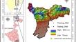
The groundwater crisis is spreading across India at an alarming rate, and it poses a serious threat to the existence of the living world. However, the nature of scarcity is uneven and spread to some unexpected locations, such as the Darjeeling Himalayan region, where rainfall is adequate. Darjeeling Himalaya, one of the most attractive tourist destinations in India, is facing a water crisis due to adverse topographical characteristics, climatic issues, and over-exploitation along with rapid urbanization, booming tourism industry, excessive deforestation, and climate change, which are making the situation progressively worsening. Consequently, a huge imbalance is generated between the requirements and availability of water, which promotes the black-marketing of water and has flourished in the entire region. For this reason, the assessment of the groundwater potential zone and its distribution in the Darjeeling Himalayan region become very important. In this regard, eight thematic maps are prepared with the help of geospatial techniques and integrated with frequency ratio and analytical hierarchy methods to prepare a groundwater potential map of the study area. The final map is reclassified into five potential zones, i.e., very low, low, moderate, high, and very high classes, respectively. The results of this analysis show that the success rate and prediction rate of the FR model are 87 and 83%, respectively. On the other hand, success and prediction rates for AHP methods are 84 and 79%, which indicates the performance of the FR method is slightly better than the AHP method. The overall result may be helpful to planners in better management or sustainable use of groundwater resources.
期刊介绍:
The Journal of Earth System Science, an International Journal, was earlier a part of the Proceedings of the Indian Academy of Sciences – Section A begun in 1934, and later split in 1978 into theme journals. This journal was published as Proceedings – Earth and Planetary Sciences since 1978, and in 2005 was renamed ‘Journal of Earth System Science’.
The journal is highly inter-disciplinary and publishes scholarly research – new data, ideas, and conceptual advances – in Earth System Science. The focus is on the evolution of the Earth as a system: manuscripts describing changes of anthropogenic origin in a limited region are not considered unless they go beyond describing the changes to include an analysis of earth-system processes. The journal''s scope includes the solid earth (geosphere), the atmosphere, the hydrosphere (including cryosphere), and the biosphere; it also addresses related aspects of planetary and space sciences. Contributions pertaining to the Indian sub- continent and the surrounding Indian-Ocean region are particularly welcome. Given that a large number of manuscripts report either observations or model results for a limited domain, manuscripts intended for publication in JESS are expected to fulfill at least one of the following three criteria.
The data should be of relevance and should be of statistically significant size and from a region from where such data are sparse. If the data are from a well-sampled region, the data size should be considerable and advance our knowledge of the region.
A model study is carried out to explain observations reported either in the same manuscript or in the literature.
The analysis, whether of data or with models, is novel and the inferences advance the current knowledge.


 分享
分享
 求助内容:
求助内容: 应助结果提醒方式:
 扫码关注我们
