Narayana Reddy Karrevula, Alugula Boyaj, P Sinha, Raghu Nadimpalli, U C Mohanty, Sahidul Islam, Akshara Kaginalkar, V Vinoj
{"title":"城市尺度 WRF 模型中行星边界层物理学在预测热带城市布巴内斯瓦尔上空热浪中的作用","authors":"Narayana Reddy Karrevula, Alugula Boyaj, P Sinha, Raghu Nadimpalli, U C Mohanty, Sahidul Islam, Akshara Kaginalkar, V Vinoj","doi":"10.1007/s12040-024-02384-2","DOIUrl":null,"url":null,"abstract":"<p>Heat waves (HWs) are currently one of the most dangerous natural catastrophes both globally and in India, particularly upsurged in urban areas. Bhubaneswar, the capital city of Odisha in India, experiences heatwaves (HWs) each year from the pre-monsoon season to the onset of the summer monsoon. The manifest increase in intensity and frequency of HWs over Bhubaneswar leads to a higher death toll, and increasing vulnerability demands accurate prediction in advance over HWs-prone zones. Numerical weather prediction models are capable of predicting these HWs, subject to the customization of suitable physical parameterization schemes. In this context, the role of five planetary boundary layer (PBL) schemes such as Yonsei University (YSU), Asymmetric Convection Model version 2 (ACM2), Medium Range Forecast (MRF), Mellor–Yamada–Janjic (MYJ), and Bougeault Lacarrere (BouLac) are assessed in predicting six HW events over Bhubaneswar city using a very high-resolution (500 m horizontal resolution) Weather Research and Forecast (WRF) model. The model simulated results are verified against the Indian Monsoon Data Assimilation and Analysis (IMDAA) reanalysis of high-resolution gridded hourly datasets. The performance of the PBL schemes varies with the meteorological parameters that have a physical relationship with HWs. The composite of statistical analysis shows that the ACM2 scheme performs better for the maximum temperature with lesser root mean square error (RMSE) by 1.67°C. The BouLac shows a lesser RMSE of 1.25°C for the early morning temperature. ACM2 and BouLac schemes have replicated the zonal (meridional) wind with an RMSE of 1.47 and 1.79 m/s (2.86 and 2.81 m/s), respectively. Both the BouLac and ACM2 performed well in representing PBL height and relative humidity. The aggregated rank analysis reveals that BouLac and ACM2 are suitable for the prediction of HW over Bhubaneswar city. The city is underwarming during the HW period, and the UHI is about 0.77°C. PBL schemes are overestimating the UHI, and a possible reason might be representations in fluxes and land-atmosphere interactions. The spatial and temporal distribution of energy fluxes simulates the same over built-up areas irrespective of the PBL schemes used in the WRF model.</p>","PeriodicalId":15609,"journal":{"name":"Journal of Earth System Science","volume":"24 1","pages":""},"PeriodicalIF":1.7000,"publicationDate":"2024-08-31","publicationTypes":"Journal Article","fieldsOfStudy":null,"isOpenAccess":false,"openAccessPdf":"","citationCount":"0","resultStr":"{\"title\":\"Role of planetary boundary layer physics in urban-scale WRF model for predicting the heat waves over tropical city Bhubaneswar\",\"authors\":\"Narayana Reddy Karrevula, Alugula Boyaj, P Sinha, Raghu Nadimpalli, U C Mohanty, Sahidul Islam, Akshara Kaginalkar, V Vinoj\",\"doi\":\"10.1007/s12040-024-02384-2\",\"DOIUrl\":null,\"url\":null,\"abstract\":\"<p>Heat waves (HWs) are currently one of the most dangerous natural catastrophes both globally and in India, particularly upsurged in urban areas. Bhubaneswar, the capital city of Odisha in India, experiences heatwaves (HWs) each year from the pre-monsoon season to the onset of the summer monsoon. The manifest increase in intensity and frequency of HWs over Bhubaneswar leads to a higher death toll, and increasing vulnerability demands accurate prediction in advance over HWs-prone zones. Numerical weather prediction models are capable of predicting these HWs, subject to the customization of suitable physical parameterization schemes. In this context, the role of five planetary boundary layer (PBL) schemes such as Yonsei University (YSU), Asymmetric Convection Model version 2 (ACM2), Medium Range Forecast (MRF), Mellor–Yamada–Janjic (MYJ), and Bougeault Lacarrere (BouLac) are assessed in predicting six HW events over Bhubaneswar city using a very high-resolution (500 m horizontal resolution) Weather Research and Forecast (WRF) model. The model simulated results are verified against the Indian Monsoon Data Assimilation and Analysis (IMDAA) reanalysis of high-resolution gridded hourly datasets. The performance of the PBL schemes varies with the meteorological parameters that have a physical relationship with HWs. The composite of statistical analysis shows that the ACM2 scheme performs better for the maximum temperature with lesser root mean square error (RMSE) by 1.67°C. The BouLac shows a lesser RMSE of 1.25°C for the early morning temperature. ACM2 and BouLac schemes have replicated the zonal (meridional) wind with an RMSE of 1.47 and 1.79 m/s (2.86 and 2.81 m/s), respectively. Both the BouLac and ACM2 performed well in representing PBL height and relative humidity. The aggregated rank analysis reveals that BouLac and ACM2 are suitable for the prediction of HW over Bhubaneswar city. The city is underwarming during the HW period, and the UHI is about 0.77°C. PBL schemes are overestimating the UHI, and a possible reason might be representations in fluxes and land-atmosphere interactions. The spatial and temporal distribution of energy fluxes simulates the same over built-up areas irrespective of the PBL schemes used in the WRF model.</p>\",\"PeriodicalId\":15609,\"journal\":{\"name\":\"Journal of Earth System Science\",\"volume\":\"24 1\",\"pages\":\"\"},\"PeriodicalIF\":1.7000,\"publicationDate\":\"2024-08-31\",\"publicationTypes\":\"Journal Article\",\"fieldsOfStudy\":null,\"isOpenAccess\":false,\"openAccessPdf\":\"\",\"citationCount\":\"0\",\"resultStr\":null,\"platform\":\"Semanticscholar\",\"paperid\":null,\"PeriodicalName\":\"Journal of Earth System Science\",\"FirstCategoryId\":\"89\",\"ListUrlMain\":\"https://doi.org/10.1007/s12040-024-02384-2\",\"RegionNum\":4,\"RegionCategory\":\"地球科学\",\"ArticlePicture\":[],\"TitleCN\":null,\"AbstractTextCN\":null,\"PMCID\":null,\"EPubDate\":\"\",\"PubModel\":\"\",\"JCR\":\"Q3\",\"JCRName\":\"GEOSCIENCES, MULTIDISCIPLINARY\",\"Score\":null,\"Total\":0}","platform":"Semanticscholar","paperid":null,"PeriodicalName":"Journal of Earth System Science","FirstCategoryId":"89","ListUrlMain":"https://doi.org/10.1007/s12040-024-02384-2","RegionNum":4,"RegionCategory":"地球科学","ArticlePicture":[],"TitleCN":null,"AbstractTextCN":null,"PMCID":null,"EPubDate":"","PubModel":"","JCR":"Q3","JCRName":"GEOSCIENCES, MULTIDISCIPLINARY","Score":null,"Total":0}
Role of planetary boundary layer physics in urban-scale WRF model for predicting the heat waves over tropical city Bhubaneswar
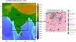
Heat waves (HWs) are currently one of the most dangerous natural catastrophes both globally and in India, particularly upsurged in urban areas. Bhubaneswar, the capital city of Odisha in India, experiences heatwaves (HWs) each year from the pre-monsoon season to the onset of the summer monsoon. The manifest increase in intensity and frequency of HWs over Bhubaneswar leads to a higher death toll, and increasing vulnerability demands accurate prediction in advance over HWs-prone zones. Numerical weather prediction models are capable of predicting these HWs, subject to the customization of suitable physical parameterization schemes. In this context, the role of five planetary boundary layer (PBL) schemes such as Yonsei University (YSU), Asymmetric Convection Model version 2 (ACM2), Medium Range Forecast (MRF), Mellor–Yamada–Janjic (MYJ), and Bougeault Lacarrere (BouLac) are assessed in predicting six HW events over Bhubaneswar city using a very high-resolution (500 m horizontal resolution) Weather Research and Forecast (WRF) model. The model simulated results are verified against the Indian Monsoon Data Assimilation and Analysis (IMDAA) reanalysis of high-resolution gridded hourly datasets. The performance of the PBL schemes varies with the meteorological parameters that have a physical relationship with HWs. The composite of statistical analysis shows that the ACM2 scheme performs better for the maximum temperature with lesser root mean square error (RMSE) by 1.67°C. The BouLac shows a lesser RMSE of 1.25°C for the early morning temperature. ACM2 and BouLac schemes have replicated the zonal (meridional) wind with an RMSE of 1.47 and 1.79 m/s (2.86 and 2.81 m/s), respectively. Both the BouLac and ACM2 performed well in representing PBL height and relative humidity. The aggregated rank analysis reveals that BouLac and ACM2 are suitable for the prediction of HW over Bhubaneswar city. The city is underwarming during the HW period, and the UHI is about 0.77°C. PBL schemes are overestimating the UHI, and a possible reason might be representations in fluxes and land-atmosphere interactions. The spatial and temporal distribution of energy fluxes simulates the same over built-up areas irrespective of the PBL schemes used in the WRF model.
期刊介绍:
The Journal of Earth System Science, an International Journal, was earlier a part of the Proceedings of the Indian Academy of Sciences – Section A begun in 1934, and later split in 1978 into theme journals. This journal was published as Proceedings – Earth and Planetary Sciences since 1978, and in 2005 was renamed ‘Journal of Earth System Science’.
The journal is highly inter-disciplinary and publishes scholarly research – new data, ideas, and conceptual advances – in Earth System Science. The focus is on the evolution of the Earth as a system: manuscripts describing changes of anthropogenic origin in a limited region are not considered unless they go beyond describing the changes to include an analysis of earth-system processes. The journal''s scope includes the solid earth (geosphere), the atmosphere, the hydrosphere (including cryosphere), and the biosphere; it also addresses related aspects of planetary and space sciences. Contributions pertaining to the Indian sub- continent and the surrounding Indian-Ocean region are particularly welcome. Given that a large number of manuscripts report either observations or model results for a limited domain, manuscripts intended for publication in JESS are expected to fulfill at least one of the following three criteria.
The data should be of relevance and should be of statistically significant size and from a region from where such data are sparse. If the data are from a well-sampled region, the data size should be considerable and advance our knowledge of the region.
A model study is carried out to explain observations reported either in the same manuscript or in the literature.
The analysis, whether of data or with models, is novel and the inferences advance the current knowledge.


 分享
分享
 求助内容:
求助内容: 应助结果提醒方式:
 扫码关注我们
