D. Karimi, M. Kabolizadeh, K. Rangzan, Z. Zaheri Abdehvand, F. Balouei
{"title":"基于空间光谱学改进沿岸带水深测量的新方法","authors":"D. Karimi, M. Kabolizadeh, K. Rangzan, Z. Zaheri Abdehvand, F. Balouei","doi":"10.1007/s13762-024-06028-2","DOIUrl":null,"url":null,"abstract":"<div><p>In-situ water depth measurement is a time-consuming and expensive process for large-scale and frequent monitoring. This underscores the need for alternative methods, such as those based on satellite imagery, which can offer a more efficient and cost-effective solution. This research explores the use of PRISMA hyperspectral images for bathymetry in Nayband Bay, South Iran. The proposed method, SSIP_PSO, includes image pan-sharpening, spectral and spatial information preservation, Particle Swarm Optimization for band ratio selection, and enhanced geometric correction. Among fusion methods tested, the Gram-Schmidt Transform proved most effective for pan-sharpening. The optimal band ratio, b4/b19, improved bathymetry accuracy, reducing root mean square error from 2.291 to 1.716. SSIP_PSO outperformed traditional methods and demonstrated the importance of preserving spatial information in bathymetry.</p></div>","PeriodicalId":589,"journal":{"name":"International Journal of Environmental Science and Technology","volume":"22 5","pages":"3359 - 3378"},"PeriodicalIF":3.4000,"publicationDate":"2024-09-09","publicationTypes":"Journal Article","fieldsOfStudy":null,"isOpenAccess":false,"openAccessPdf":"","citationCount":"0","resultStr":"{\"title\":\"New methodology for improved bathymetry of coastal zones based on spaceborne spectroscopy\",\"authors\":\"D. Karimi, M. Kabolizadeh, K. Rangzan, Z. Zaheri Abdehvand, F. Balouei\",\"doi\":\"10.1007/s13762-024-06028-2\",\"DOIUrl\":null,\"url\":null,\"abstract\":\"<div><p>In-situ water depth measurement is a time-consuming and expensive process for large-scale and frequent monitoring. This underscores the need for alternative methods, such as those based on satellite imagery, which can offer a more efficient and cost-effective solution. This research explores the use of PRISMA hyperspectral images for bathymetry in Nayband Bay, South Iran. The proposed method, SSIP_PSO, includes image pan-sharpening, spectral and spatial information preservation, Particle Swarm Optimization for band ratio selection, and enhanced geometric correction. Among fusion methods tested, the Gram-Schmidt Transform proved most effective for pan-sharpening. The optimal band ratio, b4/b19, improved bathymetry accuracy, reducing root mean square error from 2.291 to 1.716. SSIP_PSO outperformed traditional methods and demonstrated the importance of preserving spatial information in bathymetry.</p></div>\",\"PeriodicalId\":589,\"journal\":{\"name\":\"International Journal of Environmental Science and Technology\",\"volume\":\"22 5\",\"pages\":\"3359 - 3378\"},\"PeriodicalIF\":3.4000,\"publicationDate\":\"2024-09-09\",\"publicationTypes\":\"Journal Article\",\"fieldsOfStudy\":null,\"isOpenAccess\":false,\"openAccessPdf\":\"\",\"citationCount\":\"0\",\"resultStr\":null,\"platform\":\"Semanticscholar\",\"paperid\":null,\"PeriodicalName\":\"International Journal of Environmental Science and Technology\",\"FirstCategoryId\":\"93\",\"ListUrlMain\":\"https://link.springer.com/article/10.1007/s13762-024-06028-2\",\"RegionNum\":4,\"RegionCategory\":\"环境科学与生态学\",\"ArticlePicture\":[],\"TitleCN\":null,\"AbstractTextCN\":null,\"PMCID\":null,\"EPubDate\":\"\",\"PubModel\":\"\",\"JCR\":\"Q2\",\"JCRName\":\"ENVIRONMENTAL SCIENCES\",\"Score\":null,\"Total\":0}","platform":"Semanticscholar","paperid":null,"PeriodicalName":"International Journal of Environmental Science and Technology","FirstCategoryId":"93","ListUrlMain":"https://link.springer.com/article/10.1007/s13762-024-06028-2","RegionNum":4,"RegionCategory":"环境科学与生态学","ArticlePicture":[],"TitleCN":null,"AbstractTextCN":null,"PMCID":null,"EPubDate":"","PubModel":"","JCR":"Q2","JCRName":"ENVIRONMENTAL SCIENCES","Score":null,"Total":0}
New methodology for improved bathymetry of coastal zones based on spaceborne spectroscopy
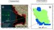
In-situ water depth measurement is a time-consuming and expensive process for large-scale and frequent monitoring. This underscores the need for alternative methods, such as those based on satellite imagery, which can offer a more efficient and cost-effective solution. This research explores the use of PRISMA hyperspectral images for bathymetry in Nayband Bay, South Iran. The proposed method, SSIP_PSO, includes image pan-sharpening, spectral and spatial information preservation, Particle Swarm Optimization for band ratio selection, and enhanced geometric correction. Among fusion methods tested, the Gram-Schmidt Transform proved most effective for pan-sharpening. The optimal band ratio, b4/b19, improved bathymetry accuracy, reducing root mean square error from 2.291 to 1.716. SSIP_PSO outperformed traditional methods and demonstrated the importance of preserving spatial information in bathymetry.
期刊介绍:
International Journal of Environmental Science and Technology (IJEST) is an international scholarly refereed research journal which aims to promote the theory and practice of environmental science and technology, innovation, engineering and management.
A broad outline of the journal''s scope includes: peer reviewed original research articles, case and technical reports, reviews and analyses papers, short communications and notes to the editor, in interdisciplinary information on the practice and status of research in environmental science and technology, both natural and man made.
The main aspects of research areas include, but are not exclusive to; environmental chemistry and biology, environments pollution control and abatement technology, transport and fate of pollutants in the environment, concentrations and dispersion of wastes in air, water, and soil, point and non-point sources pollution, heavy metals and organic compounds in the environment, atmospheric pollutants and trace gases, solid and hazardous waste management; soil biodegradation and bioremediation of contaminated sites; environmental impact assessment, industrial ecology, ecological and human risk assessment; improved energy management and auditing efficiency and environmental standards and criteria.


 分享
分享
 求助内容:
求助内容: 应助结果提醒方式:
 扫码关注我们
