Carlos Araque-Pérez, Janckarlos Reyes-Lucero, Inírida Rodriguez-Millan
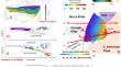
{"title":"厄瓜多尔纳斯卡板块俯冲的综合地球物理模型方法","authors":"Carlos Araque-Pérez, Janckarlos Reyes-Lucero, Inírida Rodriguez-Millan","doi":"10.1007/s11600-024-01440-1","DOIUrl":null,"url":null,"abstract":"<div><p>This research addresses 2D models of the Nazca-South America subduction zone off the coast of Ecuador using the European Improved Gravity Model of the Earth by New Techniques (EIGEN-6C4), the Earth Magnetic Anomaly Grid with a 2-arc-minute resolution model (EMAG2 V3), and the seismic catalog from the Ecuadorian Geophysical Institute of the National Polytechnic School (IGEPN). Since the Upper Cretaceous, the region has experienced several geomorphological and structural alterations within the oceanic plate (Carnegie Ridge and Grijalva Fault Zone) and continental plate (North Andean Block and South American Plate). These changes result from a complex geodynamic history involving ancient subduction zones, accretions, and roll-back stages of allochthonous oceanic terrains and the autochthonous continental coast. To ensure the accuracy of the selected gravimetric model, the EIGEN-6C4 model was statistically compared with the pure-satellite gravimetric model, GO-CONS-TIM-R6e. Several geophysical analyses, such as terrain correction, geostatistical analysis, clustering, and power spectrum, were performed to gain valuable insights into gravity and magnetic sources. Then, these results were incorporated as constraints into the forward modeling procedure, which was adjusted to hypocenters, generating four subduction profiles that were then refined by an inversion method. The 0°S profile shows a subduction angle of 15° and escalates to 35° beyond 55 km depth, with the oceanic crust thickening at the Carnegie Ridge up to 18 km. The 1°S profile displayed two inflection points implying changes in the dip angle: a transition from 14° to 7° dip angle, supporting a change to low-angle subduction, and a transition from 7° to 40°, suggesting normal subduction beneath the Andean Cordillera. In the 2°S profile, the subduction initiates with a 15° angle beneath the continental plate extending to 60 km beneath the Manabi Basin, then potentially increases to 30° beyond 120 km depth. The 3°S profile beneath the Andes revealed a stable subduction zone with a constant dip angle of 14° and flat-slab subduction. Creating a three-dimensional interpolated model between the modeled profiles as a sketch of the angle variation of the subducted slab in the Equatorian region. The small root-mean-square error indicates that the models adequately represent the data. These models provide valuable observations of the geometric variations of the subducting plate, highlighting the impact of heterogeneous physiographic elements within the oceanic crust and the presence of an ancient subduction slab derived from the Farallon Plate.</p></div>","PeriodicalId":6988,"journal":{"name":"Acta Geophysica","volume":"73 2","pages":"1041 - 1069"},"PeriodicalIF":2.1000,"publicationDate":"2024-09-18","publicationTypes":"Journal Article","fieldsOfStudy":null,"isOpenAccess":false,"openAccessPdf":"","citationCount":"0","resultStr":"{\"title\":\"Integrated geophysical model approach for Nazca Plate subduction in Ecuador\",\"authors\":\"Carlos Araque-Pérez, Janckarlos Reyes-Lucero, Inírida Rodriguez-Millan\",\"doi\":\"10.1007/s11600-024-01440-1\",\"DOIUrl\":null,\"url\":null,\"abstract\":\"<div><p>This research addresses 2D models of the Nazca-South America subduction zone off the coast of Ecuador using the European Improved Gravity Model of the Earth by New Techniques (EIGEN-6C4), the Earth Magnetic Anomaly Grid with a 2-arc-minute resolution model (EMAG2 V3), and the seismic catalog from the Ecuadorian Geophysical Institute of the National Polytechnic School (IGEPN). Since the Upper Cretaceous, the region has experienced several geomorphological and structural alterations within the oceanic plate (Carnegie Ridge and Grijalva Fault Zone) and continental plate (North Andean Block and South American Plate). These changes result from a complex geodynamic history involving ancient subduction zones, accretions, and roll-back stages of allochthonous oceanic terrains and the autochthonous continental coast. To ensure the accuracy of the selected gravimetric model, the EIGEN-6C4 model was statistically compared with the pure-satellite gravimetric model, GO-CONS-TIM-R6e. Several geophysical analyses, such as terrain correction, geostatistical analysis, clustering, and power spectrum, were performed to gain valuable insights into gravity and magnetic sources. Then, these results were incorporated as constraints into the forward modeling procedure, which was adjusted to hypocenters, generating four subduction profiles that were then refined by an inversion method. The 0°S profile shows a subduction angle of 15° and escalates to 35° beyond 55 km depth, with the oceanic crust thickening at the Carnegie Ridge up to 18 km. The 1°S profile displayed two inflection points implying changes in the dip angle: a transition from 14° to 7° dip angle, supporting a change to low-angle subduction, and a transition from 7° to 40°, suggesting normal subduction beneath the Andean Cordillera. In the 2°S profile, the subduction initiates with a 15° angle beneath the continental plate extending to 60 km beneath the Manabi Basin, then potentially increases to 30° beyond 120 km depth. The 3°S profile beneath the Andes revealed a stable subduction zone with a constant dip angle of 14° and flat-slab subduction. Creating a three-dimensional interpolated model between the modeled profiles as a sketch of the angle variation of the subducted slab in the Equatorian region. The small root-mean-square error indicates that the models adequately represent the data. These models provide valuable observations of the geometric variations of the subducting plate, highlighting the impact of heterogeneous physiographic elements within the oceanic crust and the presence of an ancient subduction slab derived from the Farallon Plate.</p></div>\",\"PeriodicalId\":6988,\"journal\":{\"name\":\"Acta Geophysica\",\"volume\":\"73 2\",\"pages\":\"1041 - 1069\"},\"PeriodicalIF\":2.1000,\"publicationDate\":\"2024-09-18\",\"publicationTypes\":\"Journal Article\",\"fieldsOfStudy\":null,\"isOpenAccess\":false,\"openAccessPdf\":\"\",\"citationCount\":\"0\",\"resultStr\":null,\"platform\":\"Semanticscholar\",\"paperid\":null,\"PeriodicalName\":\"Acta Geophysica\",\"FirstCategoryId\":\"89\",\"ListUrlMain\":\"https://link.springer.com/article/10.1007/s11600-024-01440-1\",\"RegionNum\":4,\"RegionCategory\":\"地球科学\",\"ArticlePicture\":[],\"TitleCN\":null,\"AbstractTextCN\":null,\"PMCID\":null,\"EPubDate\":\"\",\"PubModel\":\"\",\"JCR\":\"\",\"JCRName\":\"\",\"Score\":null,\"Total\":0}","platform":"Semanticscholar","paperid":null,"PeriodicalName":"Acta Geophysica","FirstCategoryId":"89","ListUrlMain":"https://link.springer.com/article/10.1007/s11600-024-01440-1","RegionNum":4,"RegionCategory":"地球科学","ArticlePicture":[],"TitleCN":null,"AbstractTextCN":null,"PMCID":null,"EPubDate":"","PubModel":"","JCR":"","JCRName":"","Score":null,"Total":0}
Integrated geophysical model approach for Nazca Plate subduction in Ecuador
This research addresses 2D models of the Nazca-South America subduction zone off the coast of Ecuador using the European Improved Gravity Model of the Earth by New Techniques (EIGEN-6C4), the Earth Magnetic Anomaly Grid with a 2-arc-minute resolution model (EMAG2 V3), and the seismic catalog from the Ecuadorian Geophysical Institute of the National Polytechnic School (IGEPN). Since the Upper Cretaceous, the region has experienced several geomorphological and structural alterations within the oceanic plate (Carnegie Ridge and Grijalva Fault Zone) and continental plate (North Andean Block and South American Plate). These changes result from a complex geodynamic history involving ancient subduction zones, accretions, and roll-back stages of allochthonous oceanic terrains and the autochthonous continental coast. To ensure the accuracy of the selected gravimetric model, the EIGEN-6C4 model was statistically compared with the pure-satellite gravimetric model, GO-CONS-TIM-R6e. Several geophysical analyses, such as terrain correction, geostatistical analysis, clustering, and power spectrum, were performed to gain valuable insights into gravity and magnetic sources. Then, these results were incorporated as constraints into the forward modeling procedure, which was adjusted to hypocenters, generating four subduction profiles that were then refined by an inversion method. The 0°S profile shows a subduction angle of 15° and escalates to 35° beyond 55 km depth, with the oceanic crust thickening at the Carnegie Ridge up to 18 km. The 1°S profile displayed two inflection points implying changes in the dip angle: a transition from 14° to 7° dip angle, supporting a change to low-angle subduction, and a transition from 7° to 40°, suggesting normal subduction beneath the Andean Cordillera. In the 2°S profile, the subduction initiates with a 15° angle beneath the continental plate extending to 60 km beneath the Manabi Basin, then potentially increases to 30° beyond 120 km depth. The 3°S profile beneath the Andes revealed a stable subduction zone with a constant dip angle of 14° and flat-slab subduction. Creating a three-dimensional interpolated model between the modeled profiles as a sketch of the angle variation of the subducted slab in the Equatorian region. The small root-mean-square error indicates that the models adequately represent the data. These models provide valuable observations of the geometric variations of the subducting plate, highlighting the impact of heterogeneous physiographic elements within the oceanic crust and the presence of an ancient subduction slab derived from the Farallon Plate.
期刊介绍:
Acta Geophysica is open to all kinds of manuscripts including research and review articles, short communications, comments to published papers, letters to the Editor as well as book reviews. Some of the issues are fully devoted to particular topics; we do encourage proposals for such topical issues. We accept submissions from scientists world-wide, offering high scientific and editorial standard and comprehensive treatment of the discussed topics.


 分享
分享
 求助内容:
求助内容: 应助结果提醒方式:
 扫码关注我们
