Yellalacheruvu Giri, M Radhakrishna, Peter Betts, T K Biswal, Robin Armit, Sumanta Kumar Sathapathy, P U Naveen
{"title":"东高止山脉移动带南部新生代缝合的证据:对努纳超大陆的影响","authors":"Yellalacheruvu Giri, M Radhakrishna, Peter Betts, T K Biswal, Robin Armit, Sumanta Kumar Sathapathy, P U Naveen","doi":"10.1007/s12040-024-02396-y","DOIUrl":null,"url":null,"abstract":"<h3 data-test=\"abstract-sub-heading\">Abstract</h3><p>The Mesoproterozoic rocks of the Krishna Province in the Eastern Ghats Mobile Belt are situated at the edge of the Indian interior cratons and the mobile belts along the edge. We use newly acquired high-resolution gravity and magnetic along with the regional geophysical data to delineate the faults, lineaments, and subsurface boundaries between the various domains of the Krishna Province. We use this data to forward model the crustal architecture below these terranes. Our analysis shows that the Ongole domain rocks are continuing further southwards up to the Nellore and below the K–G Basin on the north side at subsurface levels. The Vinjamur and Udayagiri domains of the Krishna Province are merged into a single narrow belt known as the Nellore–Khammam Schist Belt. The joint 2D modelling of the gravity and magnetic data across these domains reveals two easterly dipping parallel thrusts separating the Dharwar–Nellore–Khammam Schist Belt and Nellore–Khammam Schist Belt–Eastern Ghats Mobile Belt, respectively. The interpreted suture between the Nellore–Khammam Schist Belt and Ongole domain of EGMB is characterized by the ophiolite and alkaline complexes of Mesoproterozoic ages. We propose that the collision between the Krishna Province and Indian Cratons occurred during the Nuna amalgamation.</p><h3 data-test=\"abstract-sub-heading\">Research highlights</h3><ul>\n<li>\n<p>The detailed crustal structure across the Dharwar Craton and EGMB was analyzed using geophysical data.</p>\n</li>\n<li>\n<p>Redefined the boundaries between the various domains of the Krishna Province.</p>\n</li>\n<li>\n<p>A paleo suture was identified between the Eastern Ghats Mobile Belt and the Nellore–Khammam Schist Belt.</p>\n</li>\n</ul>","PeriodicalId":15609,"journal":{"name":"Journal of Earth System Science","volume":"53 1","pages":""},"PeriodicalIF":1.7000,"publicationDate":"2024-09-17","publicationTypes":"Journal Article","fieldsOfStudy":null,"isOpenAccess":false,"openAccessPdf":"","citationCount":"0","resultStr":"{\"title\":\"Evidence of a Proterozoic suture along the southern part of Eastern Ghats Mobile Belt: Implications for the Nuna supercontinent\",\"authors\":\"Yellalacheruvu Giri, M Radhakrishna, Peter Betts, T K Biswal, Robin Armit, Sumanta Kumar Sathapathy, P U Naveen\",\"doi\":\"10.1007/s12040-024-02396-y\",\"DOIUrl\":null,\"url\":null,\"abstract\":\"<h3 data-test=\\\"abstract-sub-heading\\\">Abstract</h3><p>The Mesoproterozoic rocks of the Krishna Province in the Eastern Ghats Mobile Belt are situated at the edge of the Indian interior cratons and the mobile belts along the edge. We use newly acquired high-resolution gravity and magnetic along with the regional geophysical data to delineate the faults, lineaments, and subsurface boundaries between the various domains of the Krishna Province. We use this data to forward model the crustal architecture below these terranes. Our analysis shows that the Ongole domain rocks are continuing further southwards up to the Nellore and below the K–G Basin on the north side at subsurface levels. The Vinjamur and Udayagiri domains of the Krishna Province are merged into a single narrow belt known as the Nellore–Khammam Schist Belt. The joint 2D modelling of the gravity and magnetic data across these domains reveals two easterly dipping parallel thrusts separating the Dharwar–Nellore–Khammam Schist Belt and Nellore–Khammam Schist Belt–Eastern Ghats Mobile Belt, respectively. The interpreted suture between the Nellore–Khammam Schist Belt and Ongole domain of EGMB is characterized by the ophiolite and alkaline complexes of Mesoproterozoic ages. We propose that the collision between the Krishna Province and Indian Cratons occurred during the Nuna amalgamation.</p><h3 data-test=\\\"abstract-sub-heading\\\">Research highlights</h3><ul>\\n<li>\\n<p>The detailed crustal structure across the Dharwar Craton and EGMB was analyzed using geophysical data.</p>\\n</li>\\n<li>\\n<p>Redefined the boundaries between the various domains of the Krishna Province.</p>\\n</li>\\n<li>\\n<p>A paleo suture was identified between the Eastern Ghats Mobile Belt and the Nellore–Khammam Schist Belt.</p>\\n</li>\\n</ul>\",\"PeriodicalId\":15609,\"journal\":{\"name\":\"Journal of Earth System Science\",\"volume\":\"53 1\",\"pages\":\"\"},\"PeriodicalIF\":1.7000,\"publicationDate\":\"2024-09-17\",\"publicationTypes\":\"Journal Article\",\"fieldsOfStudy\":null,\"isOpenAccess\":false,\"openAccessPdf\":\"\",\"citationCount\":\"0\",\"resultStr\":null,\"platform\":\"Semanticscholar\",\"paperid\":null,\"PeriodicalName\":\"Journal of Earth System Science\",\"FirstCategoryId\":\"89\",\"ListUrlMain\":\"https://doi.org/10.1007/s12040-024-02396-y\",\"RegionNum\":4,\"RegionCategory\":\"地球科学\",\"ArticlePicture\":[],\"TitleCN\":null,\"AbstractTextCN\":null,\"PMCID\":null,\"EPubDate\":\"\",\"PubModel\":\"\",\"JCR\":\"Q3\",\"JCRName\":\"GEOSCIENCES, MULTIDISCIPLINARY\",\"Score\":null,\"Total\":0}","platform":"Semanticscholar","paperid":null,"PeriodicalName":"Journal of Earth System Science","FirstCategoryId":"89","ListUrlMain":"https://doi.org/10.1007/s12040-024-02396-y","RegionNum":4,"RegionCategory":"地球科学","ArticlePicture":[],"TitleCN":null,"AbstractTextCN":null,"PMCID":null,"EPubDate":"","PubModel":"","JCR":"Q3","JCRName":"GEOSCIENCES, MULTIDISCIPLINARY","Score":null,"Total":0}
Evidence of a Proterozoic suture along the southern part of Eastern Ghats Mobile Belt: Implications for the Nuna supercontinent
Abstract
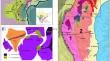
The Mesoproterozoic rocks of the Krishna Province in the Eastern Ghats Mobile Belt are situated at the edge of the Indian interior cratons and the mobile belts along the edge. We use newly acquired high-resolution gravity and magnetic along with the regional geophysical data to delineate the faults, lineaments, and subsurface boundaries between the various domains of the Krishna Province. We use this data to forward model the crustal architecture below these terranes. Our analysis shows that the Ongole domain rocks are continuing further southwards up to the Nellore and below the K–G Basin on the north side at subsurface levels. The Vinjamur and Udayagiri domains of the Krishna Province are merged into a single narrow belt known as the Nellore–Khammam Schist Belt. The joint 2D modelling of the gravity and magnetic data across these domains reveals two easterly dipping parallel thrusts separating the Dharwar–Nellore–Khammam Schist Belt and Nellore–Khammam Schist Belt–Eastern Ghats Mobile Belt, respectively. The interpreted suture between the Nellore–Khammam Schist Belt and Ongole domain of EGMB is characterized by the ophiolite and alkaline complexes of Mesoproterozoic ages. We propose that the collision between the Krishna Province and Indian Cratons occurred during the Nuna amalgamation.
Research highlights
The detailed crustal structure across the Dharwar Craton and EGMB was analyzed using geophysical data.
Redefined the boundaries between the various domains of the Krishna Province.
A paleo suture was identified between the Eastern Ghats Mobile Belt and the Nellore–Khammam Schist Belt.
期刊介绍:
The Journal of Earth System Science, an International Journal, was earlier a part of the Proceedings of the Indian Academy of Sciences – Section A begun in 1934, and later split in 1978 into theme journals. This journal was published as Proceedings – Earth and Planetary Sciences since 1978, and in 2005 was renamed ‘Journal of Earth System Science’.
The journal is highly inter-disciplinary and publishes scholarly research – new data, ideas, and conceptual advances – in Earth System Science. The focus is on the evolution of the Earth as a system: manuscripts describing changes of anthropogenic origin in a limited region are not considered unless they go beyond describing the changes to include an analysis of earth-system processes. The journal''s scope includes the solid earth (geosphere), the atmosphere, the hydrosphere (including cryosphere), and the biosphere; it also addresses related aspects of planetary and space sciences. Contributions pertaining to the Indian sub- continent and the surrounding Indian-Ocean region are particularly welcome. Given that a large number of manuscripts report either observations or model results for a limited domain, manuscripts intended for publication in JESS are expected to fulfill at least one of the following three criteria.
The data should be of relevance and should be of statistically significant size and from a region from where such data are sparse. If the data are from a well-sampled region, the data size should be considerable and advance our knowledge of the region.
A model study is carried out to explain observations reported either in the same manuscript or in the literature.
The analysis, whether of data or with models, is novel and the inferences advance the current knowledge.


 分享
分享
 求助内容:
求助内容: 应助结果提醒方式:
 扫码关注我们
