{"title":"整合机器学习和遥感技术,评估孟买沿岸红树林的变化探测情况","authors":"Suraj Sawant, Praneetha Bonala, Amit Joshi, Mahesh Shindikar, Abhilasha Patil, Swapnil Vyas, Deepti Deobagkar","doi":"10.1007/s12040-024-02378-0","DOIUrl":null,"url":null,"abstract":"<p>Mangrove forests, being high-yielding ecosystems, often dominate the intertidal sites along equatorial and subtropical coasts. Despite the known significance of mangroves to the coastal ecology, especially fisheries, deforestation remains a severe danger due to coercion for forest products, ground transformation for aquaculture, and seaside urban growth. Remote sensing is integral in mapping and analysing changes in mangrove forests’ areal extent and spatial patterns due to natural disasters and anthropogenic causes over the last three decades. This work depicts remote sensing analysis for change detection in mangrove forest land use land cover from 2014 to 2019. Indian Remote-Sensing Satellite Resourcesat-2 LISS-IV datasets have been used for analysis. A comparison with the Sentinel-2A dataset and two machine learning models: Random Forest and Classification and Regression Tree, has been performed with 2019 data. This work identifies CART as a suitable choice for supervised landform classification utilising remotely sensed geophysical data that is used to decipher spatial changes concurred over time. An overall growth in the mangrove cover was observed from 2014 to 2019, from 86.26 to 89.63 <span>\\({\\hbox {km}^{2}}\\)</span>, along the Mumbai coastline. Spatial comparison over the years shows the growth and loss of land-use cover areas. The performance metrics such as overall accuracy, producer accuracy, Kappa coefficient, and Matthews correlation coefficient are computed. The experiments were conducted using the Google Earth Engine, a powerful cloud computing platform.</p>","PeriodicalId":15609,"journal":{"name":"Journal of Earth System Science","volume":"30 1","pages":""},"PeriodicalIF":1.7000,"publicationDate":"2024-09-16","publicationTypes":"Journal Article","fieldsOfStudy":null,"isOpenAccess":false,"openAccessPdf":"","citationCount":"0","resultStr":"{\"title\":\"Integration of machine learning and remote sensing for assessing the change detection of mangrove forests along the Mumbai coast\",\"authors\":\"Suraj Sawant, Praneetha Bonala, Amit Joshi, Mahesh Shindikar, Abhilasha Patil, Swapnil Vyas, Deepti Deobagkar\",\"doi\":\"10.1007/s12040-024-02378-0\",\"DOIUrl\":null,\"url\":null,\"abstract\":\"<p>Mangrove forests, being high-yielding ecosystems, often dominate the intertidal sites along equatorial and subtropical coasts. Despite the known significance of mangroves to the coastal ecology, especially fisheries, deforestation remains a severe danger due to coercion for forest products, ground transformation for aquaculture, and seaside urban growth. Remote sensing is integral in mapping and analysing changes in mangrove forests’ areal extent and spatial patterns due to natural disasters and anthropogenic causes over the last three decades. This work depicts remote sensing analysis for change detection in mangrove forest land use land cover from 2014 to 2019. Indian Remote-Sensing Satellite Resourcesat-2 LISS-IV datasets have been used for analysis. A comparison with the Sentinel-2A dataset and two machine learning models: Random Forest and Classification and Regression Tree, has been performed with 2019 data. This work identifies CART as a suitable choice for supervised landform classification utilising remotely sensed geophysical data that is used to decipher spatial changes concurred over time. An overall growth in the mangrove cover was observed from 2014 to 2019, from 86.26 to 89.63 <span>\\\\({\\\\hbox {km}^{2}}\\\\)</span>, along the Mumbai coastline. Spatial comparison over the years shows the growth and loss of land-use cover areas. The performance metrics such as overall accuracy, producer accuracy, Kappa coefficient, and Matthews correlation coefficient are computed. The experiments were conducted using the Google Earth Engine, a powerful cloud computing platform.</p>\",\"PeriodicalId\":15609,\"journal\":{\"name\":\"Journal of Earth System Science\",\"volume\":\"30 1\",\"pages\":\"\"},\"PeriodicalIF\":1.7000,\"publicationDate\":\"2024-09-16\",\"publicationTypes\":\"Journal Article\",\"fieldsOfStudy\":null,\"isOpenAccess\":false,\"openAccessPdf\":\"\",\"citationCount\":\"0\",\"resultStr\":null,\"platform\":\"Semanticscholar\",\"paperid\":null,\"PeriodicalName\":\"Journal of Earth System Science\",\"FirstCategoryId\":\"89\",\"ListUrlMain\":\"https://doi.org/10.1007/s12040-024-02378-0\",\"RegionNum\":4,\"RegionCategory\":\"地球科学\",\"ArticlePicture\":[],\"TitleCN\":null,\"AbstractTextCN\":null,\"PMCID\":null,\"EPubDate\":\"\",\"PubModel\":\"\",\"JCR\":\"Q3\",\"JCRName\":\"GEOSCIENCES, MULTIDISCIPLINARY\",\"Score\":null,\"Total\":0}","platform":"Semanticscholar","paperid":null,"PeriodicalName":"Journal of Earth System Science","FirstCategoryId":"89","ListUrlMain":"https://doi.org/10.1007/s12040-024-02378-0","RegionNum":4,"RegionCategory":"地球科学","ArticlePicture":[],"TitleCN":null,"AbstractTextCN":null,"PMCID":null,"EPubDate":"","PubModel":"","JCR":"Q3","JCRName":"GEOSCIENCES, MULTIDISCIPLINARY","Score":null,"Total":0}
Integration of machine learning and remote sensing for assessing the change detection of mangrove forests along the Mumbai coast
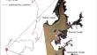
Mangrove forests, being high-yielding ecosystems, often dominate the intertidal sites along equatorial and subtropical coasts. Despite the known significance of mangroves to the coastal ecology, especially fisheries, deforestation remains a severe danger due to coercion for forest products, ground transformation for aquaculture, and seaside urban growth. Remote sensing is integral in mapping and analysing changes in mangrove forests’ areal extent and spatial patterns due to natural disasters and anthropogenic causes over the last three decades. This work depicts remote sensing analysis for change detection in mangrove forest land use land cover from 2014 to 2019. Indian Remote-Sensing Satellite Resourcesat-2 LISS-IV datasets have been used for analysis. A comparison with the Sentinel-2A dataset and two machine learning models: Random Forest and Classification and Regression Tree, has been performed with 2019 data. This work identifies CART as a suitable choice for supervised landform classification utilising remotely sensed geophysical data that is used to decipher spatial changes concurred over time. An overall growth in the mangrove cover was observed from 2014 to 2019, from 86.26 to 89.63 \({\hbox {km}^{2}}\), along the Mumbai coastline. Spatial comparison over the years shows the growth and loss of land-use cover areas. The performance metrics such as overall accuracy, producer accuracy, Kappa coefficient, and Matthews correlation coefficient are computed. The experiments were conducted using the Google Earth Engine, a powerful cloud computing platform.
期刊介绍:
The Journal of Earth System Science, an International Journal, was earlier a part of the Proceedings of the Indian Academy of Sciences – Section A begun in 1934, and later split in 1978 into theme journals. This journal was published as Proceedings – Earth and Planetary Sciences since 1978, and in 2005 was renamed ‘Journal of Earth System Science’.
The journal is highly inter-disciplinary and publishes scholarly research – new data, ideas, and conceptual advances – in Earth System Science. The focus is on the evolution of the Earth as a system: manuscripts describing changes of anthropogenic origin in a limited region are not considered unless they go beyond describing the changes to include an analysis of earth-system processes. The journal''s scope includes the solid earth (geosphere), the atmosphere, the hydrosphere (including cryosphere), and the biosphere; it also addresses related aspects of planetary and space sciences. Contributions pertaining to the Indian sub- continent and the surrounding Indian-Ocean region are particularly welcome. Given that a large number of manuscripts report either observations or model results for a limited domain, manuscripts intended for publication in JESS are expected to fulfill at least one of the following three criteria.
The data should be of relevance and should be of statistically significant size and from a region from where such data are sparse. If the data are from a well-sampled region, the data size should be considerable and advance our knowledge of the region.
A model study is carried out to explain observations reported either in the same manuscript or in the literature.
The analysis, whether of data or with models, is novel and the inferences advance the current knowledge.


 分享
分享
 求助内容:
求助内容: 应助结果提醒方式:
 扫码关注我们
