{"title":"机载测量揭示了爱荷华州氧化亚氮排放的高时空变化和重尾特征","authors":"Natasha Dacic, Genevieve Plant, Eric A. Kort","doi":"10.1029/2024JD041403","DOIUrl":null,"url":null,"abstract":"<p>Nitrous oxide (N<sub>2</sub>O) emissions from croplands contribute substantially to the climate impact of agriculture. Emissions of N<sub>2</sub>O are controlled by both anthropogenic and environmental factors and can vary by orders of magnitude over short times and distances. This nature of emissions is difficult to capture with models and presents an observational challenge. In the 2021 and 2022 growing season, we collected airborne measurements of N<sub>2</sub>O over Iowa to characterize N<sub>2</sub>O emissions at the farm to multi-county spatial scales across days. We link our airborne observations to surface emissions using a Lagrangian particle dispersion model and quantify emissions using a Bayesian inversion framework. We find emissions magnitudes across Iowa, showing greater skew than modeled predictions, with a small fraction of fields contributing disproportionately to the total [25% of the domain contributing to 52%–77% of total emissions]. In addition to the high spatial variation, we find high temporal variability between flight days by a factor of 2 at the 100 km scale, and an order of magnitude at the 2 km scale], with peak emissions occurring at median soil moisture. This work illustrates the importance of transient, intense emissions from concentrated areas in explaining total cropland emissions, and demonstrates how airborne measurements can provide insights into variation that may be missed by other observational systems. Investigation into environmental factors highlights the need for observations, models and their input data to be spatiotemporally resolved to enable direct comparison, facilitating evaluation of predicted and reported emissions and providing guidance and feedback on mitigation strategies.</p>","PeriodicalId":15986,"journal":{"name":"Journal of Geophysical Research: Atmospheres","volume":"129 19","pages":""},"PeriodicalIF":3.4000,"publicationDate":"2024-09-28","publicationTypes":"Journal Article","fieldsOfStudy":null,"isOpenAccess":false,"openAccessPdf":"https://onlinelibrary.wiley.com/doi/epdf/10.1029/2024JD041403","citationCount":"0","resultStr":"{\"title\":\"Airborne Measurements Reveal High Spatiotemporal Variation and the Heavy-Tail Characteristic of Nitrous Oxide Emissions in Iowa\",\"authors\":\"Natasha Dacic, Genevieve Plant, Eric A. Kort\",\"doi\":\"10.1029/2024JD041403\",\"DOIUrl\":null,\"url\":null,\"abstract\":\"<p>Nitrous oxide (N<sub>2</sub>O) emissions from croplands contribute substantially to the climate impact of agriculture. Emissions of N<sub>2</sub>O are controlled by both anthropogenic and environmental factors and can vary by orders of magnitude over short times and distances. This nature of emissions is difficult to capture with models and presents an observational challenge. In the 2021 and 2022 growing season, we collected airborne measurements of N<sub>2</sub>O over Iowa to characterize N<sub>2</sub>O emissions at the farm to multi-county spatial scales across days. We link our airborne observations to surface emissions using a Lagrangian particle dispersion model and quantify emissions using a Bayesian inversion framework. We find emissions magnitudes across Iowa, showing greater skew than modeled predictions, with a small fraction of fields contributing disproportionately to the total [25% of the domain contributing to 52%–77% of total emissions]. In addition to the high spatial variation, we find high temporal variability between flight days by a factor of 2 at the 100 km scale, and an order of magnitude at the 2 km scale], with peak emissions occurring at median soil moisture. This work illustrates the importance of transient, intense emissions from concentrated areas in explaining total cropland emissions, and demonstrates how airborne measurements can provide insights into variation that may be missed by other observational systems. Investigation into environmental factors highlights the need for observations, models and their input data to be spatiotemporally resolved to enable direct comparison, facilitating evaluation of predicted and reported emissions and providing guidance and feedback on mitigation strategies.</p>\",\"PeriodicalId\":15986,\"journal\":{\"name\":\"Journal of Geophysical Research: Atmospheres\",\"volume\":\"129 19\",\"pages\":\"\"},\"PeriodicalIF\":3.4000,\"publicationDate\":\"2024-09-28\",\"publicationTypes\":\"Journal Article\",\"fieldsOfStudy\":null,\"isOpenAccess\":false,\"openAccessPdf\":\"https://onlinelibrary.wiley.com/doi/epdf/10.1029/2024JD041403\",\"citationCount\":\"0\",\"resultStr\":null,\"platform\":\"Semanticscholar\",\"paperid\":null,\"PeriodicalName\":\"Journal of Geophysical Research: Atmospheres\",\"FirstCategoryId\":\"89\",\"ListUrlMain\":\"https://agupubs.onlinelibrary.wiley.com/doi/10.1029/2024JD041403\",\"RegionNum\":2,\"RegionCategory\":\"地球科学\",\"ArticlePicture\":[],\"TitleCN\":null,\"AbstractTextCN\":null,\"PMCID\":null,\"EPubDate\":\"\",\"PubModel\":\"\",\"JCR\":\"Q2\",\"JCRName\":\"METEOROLOGY & ATMOSPHERIC SCIENCES\",\"Score\":null,\"Total\":0}","platform":"Semanticscholar","paperid":null,"PeriodicalName":"Journal of Geophysical Research: Atmospheres","FirstCategoryId":"89","ListUrlMain":"https://agupubs.onlinelibrary.wiley.com/doi/10.1029/2024JD041403","RegionNum":2,"RegionCategory":"地球科学","ArticlePicture":[],"TitleCN":null,"AbstractTextCN":null,"PMCID":null,"EPubDate":"","PubModel":"","JCR":"Q2","JCRName":"METEOROLOGY & ATMOSPHERIC SCIENCES","Score":null,"Total":0}
Airborne Measurements Reveal High Spatiotemporal Variation and the Heavy-Tail Characteristic of Nitrous Oxide Emissions in Iowa
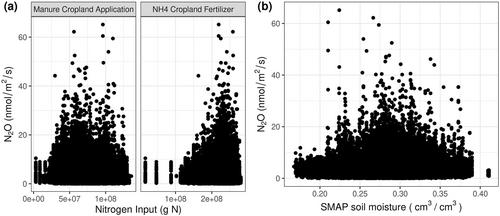
Nitrous oxide (N2O) emissions from croplands contribute substantially to the climate impact of agriculture. Emissions of N2O are controlled by both anthropogenic and environmental factors and can vary by orders of magnitude over short times and distances. This nature of emissions is difficult to capture with models and presents an observational challenge. In the 2021 and 2022 growing season, we collected airborne measurements of N2O over Iowa to characterize N2O emissions at the farm to multi-county spatial scales across days. We link our airborne observations to surface emissions using a Lagrangian particle dispersion model and quantify emissions using a Bayesian inversion framework. We find emissions magnitudes across Iowa, showing greater skew than modeled predictions, with a small fraction of fields contributing disproportionately to the total [25% of the domain contributing to 52%–77% of total emissions]. In addition to the high spatial variation, we find high temporal variability between flight days by a factor of 2 at the 100 km scale, and an order of magnitude at the 2 km scale], with peak emissions occurring at median soil moisture. This work illustrates the importance of transient, intense emissions from concentrated areas in explaining total cropland emissions, and demonstrates how airborne measurements can provide insights into variation that may be missed by other observational systems. Investigation into environmental factors highlights the need for observations, models and their input data to be spatiotemporally resolved to enable direct comparison, facilitating evaluation of predicted and reported emissions and providing guidance and feedback on mitigation strategies.
期刊介绍:
JGR: Atmospheres publishes articles that advance and improve understanding of atmospheric properties and processes, including the interaction of the atmosphere with other components of the Earth system.


 分享
分享
 求助内容:
求助内容: 应助结果提醒方式:
 扫码关注我们
