{"title":"将喜马拉雅西部流域尺度的水文与气候参数联系起来:卫星数据、温度指数建模和现场观测的应用","authors":"Smriti Srivastava , Mohd. Farooq Azam , Praveen Kumar Thakur","doi":"10.1016/j.gsf.2024.101936","DOIUrl":null,"url":null,"abstract":"<div><div>Due to limited spatial and temporal in-situ runoff data availability, Himalaya-Karakoram (HK) glaciohydrology has a significant knowledge gap between large-scale and small-scale runoff modelling studies. This study reconstructs longest basin-wide runoff series in Chandra-Bhaga Basin by applying a high-resolution glaciohydrological model <em>SPHY</em> (Spatial Processes in Hydrology) over 1950–2022. Two-tier model calibration is done using in-situ basin-wide runoff (1973–2006) and MODIS snow cover (2003–2018). Model validation is done against in-situ Chhota Shigri Glacier catchment-wide runoff (2010–2015). The modelled mean annual basin-wide runoff is 60.21 ± 6.17 m<sup>3</sup>/s over 1950–2022, with maximum runoff in summer-monsoon months, peaking in July (182.69 m<sup>3</sup>/s). Glacier runoff (ice melt + snowmelt over glacier) contributes maximum (39%) followed by equal contributions from snowmelt runoff from non-glacierized basin area and baseflow (25%), while rainfall-runoff contributes minimum (11 %) to total runoff. There is a significant volumetric increase by ∼7% from pre- (59.17 m<sup>3</sup>/s) to post-2000 (63.47 m<sup>3</sup>/s) mainly because of early onset of snowmelt post-2000 that resulted in a hydrograph shift by ∼25 days earlier in spring. The glacier runoff is overestimated by 3% from RGI 7.0 inventory compared to different manually delineated inventories over 1950–2022, because of higher glacierized area from RGI 7.0. The precipitation shows a negative trend, but total runoff shows a positive trend due to positive trend of temperature that resulted in more glacier runoff and rainfall-runoff for basin over last 72 years. Basin-wide runoff is mainly governed by summer temperature which directly controls the amount of glacier and snowmelt runoffs and is supported by summer rainfall. This study highlights importance of basin-scale model calibration with in-situ data in large scale studies and stresses the need for in-situ observations in high-altitude Himalayan region. Basin-scale calibrated model parameters are transferable to glacier catchment scale within Chandra-Bhaga Basin, showing the model robustness at a small catchment scale.</div></div>","PeriodicalId":12711,"journal":{"name":"Geoscience frontiers","volume":"15 6","pages":"Article 101936"},"PeriodicalIF":12.7000,"publicationDate":"2024-11-01","publicationTypes":"Journal Article","fieldsOfStudy":null,"isOpenAccess":false,"openAccessPdf":"","citationCount":"0","resultStr":"{\"title\":\"Linking basin-scale hydrology with climatic parameters in western Himalaya: Application of satellite data, temperature index modelling and in-situ observations\",\"authors\":\"Smriti Srivastava , Mohd. Farooq Azam , Praveen Kumar Thakur\",\"doi\":\"10.1016/j.gsf.2024.101936\",\"DOIUrl\":null,\"url\":null,\"abstract\":\"<div><div>Due to limited spatial and temporal in-situ runoff data availability, Himalaya-Karakoram (HK) glaciohydrology has a significant knowledge gap between large-scale and small-scale runoff modelling studies. This study reconstructs longest basin-wide runoff series in Chandra-Bhaga Basin by applying a high-resolution glaciohydrological model <em>SPHY</em> (Spatial Processes in Hydrology) over 1950–2022. Two-tier model calibration is done using in-situ basin-wide runoff (1973–2006) and MODIS snow cover (2003–2018). Model validation is done against in-situ Chhota Shigri Glacier catchment-wide runoff (2010–2015). The modelled mean annual basin-wide runoff is 60.21 ± 6.17 m<sup>3</sup>/s over 1950–2022, with maximum runoff in summer-monsoon months, peaking in July (182.69 m<sup>3</sup>/s). Glacier runoff (ice melt + snowmelt over glacier) contributes maximum (39%) followed by equal contributions from snowmelt runoff from non-glacierized basin area and baseflow (25%), while rainfall-runoff contributes minimum (11 %) to total runoff. There is a significant volumetric increase by ∼7% from pre- (59.17 m<sup>3</sup>/s) to post-2000 (63.47 m<sup>3</sup>/s) mainly because of early onset of snowmelt post-2000 that resulted in a hydrograph shift by ∼25 days earlier in spring. The glacier runoff is overestimated by 3% from RGI 7.0 inventory compared to different manually delineated inventories over 1950–2022, because of higher glacierized area from RGI 7.0. The precipitation shows a negative trend, but total runoff shows a positive trend due to positive trend of temperature that resulted in more glacier runoff and rainfall-runoff for basin over last 72 years. Basin-wide runoff is mainly governed by summer temperature which directly controls the amount of glacier and snowmelt runoffs and is supported by summer rainfall. This study highlights importance of basin-scale model calibration with in-situ data in large scale studies and stresses the need for in-situ observations in high-altitude Himalayan region. Basin-scale calibrated model parameters are transferable to glacier catchment scale within Chandra-Bhaga Basin, showing the model robustness at a small catchment scale.</div></div>\",\"PeriodicalId\":12711,\"journal\":{\"name\":\"Geoscience frontiers\",\"volume\":\"15 6\",\"pages\":\"Article 101936\"},\"PeriodicalIF\":12.7000,\"publicationDate\":\"2024-11-01\",\"publicationTypes\":\"Journal Article\",\"fieldsOfStudy\":null,\"isOpenAccess\":false,\"openAccessPdf\":\"\",\"citationCount\":\"0\",\"resultStr\":null,\"platform\":\"Semanticscholar\",\"paperid\":null,\"PeriodicalName\":\"Geoscience frontiers\",\"FirstCategoryId\":\"89\",\"ListUrlMain\":\"https://www.sciencedirect.com/science/article/pii/S1674987124001609\",\"RegionNum\":1,\"RegionCategory\":\"地球科学\",\"ArticlePicture\":[],\"TitleCN\":null,\"AbstractTextCN\":null,\"PMCID\":null,\"EPubDate\":\"2024/9/24 0:00:00\",\"PubModel\":\"Epub\",\"JCR\":\"Q1\",\"JCRName\":\"GEOSCIENCES, MULTIDISCIPLINARY\",\"Score\":null,\"Total\":0}","platform":"Semanticscholar","paperid":null,"PeriodicalName":"Geoscience frontiers","FirstCategoryId":"89","ListUrlMain":"https://www.sciencedirect.com/science/article/pii/S1674987124001609","RegionNum":1,"RegionCategory":"地球科学","ArticlePicture":[],"TitleCN":null,"AbstractTextCN":null,"PMCID":null,"EPubDate":"2024/9/24 0:00:00","PubModel":"Epub","JCR":"Q1","JCRName":"GEOSCIENCES, MULTIDISCIPLINARY","Score":null,"Total":0}
Linking basin-scale hydrology with climatic parameters in western Himalaya: Application of satellite data, temperature index modelling and in-situ observations
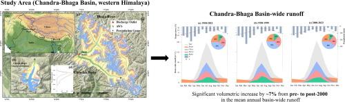
Due to limited spatial and temporal in-situ runoff data availability, Himalaya-Karakoram (HK) glaciohydrology has a significant knowledge gap between large-scale and small-scale runoff modelling studies. This study reconstructs longest basin-wide runoff series in Chandra-Bhaga Basin by applying a high-resolution glaciohydrological model SPHY (Spatial Processes in Hydrology) over 1950–2022. Two-tier model calibration is done using in-situ basin-wide runoff (1973–2006) and MODIS snow cover (2003–2018). Model validation is done against in-situ Chhota Shigri Glacier catchment-wide runoff (2010–2015). The modelled mean annual basin-wide runoff is 60.21 ± 6.17 m3/s over 1950–2022, with maximum runoff in summer-monsoon months, peaking in July (182.69 m3/s). Glacier runoff (ice melt + snowmelt over glacier) contributes maximum (39%) followed by equal contributions from snowmelt runoff from non-glacierized basin area and baseflow (25%), while rainfall-runoff contributes minimum (11 %) to total runoff. There is a significant volumetric increase by ∼7% from pre- (59.17 m3/s) to post-2000 (63.47 m3/s) mainly because of early onset of snowmelt post-2000 that resulted in a hydrograph shift by ∼25 days earlier in spring. The glacier runoff is overestimated by 3% from RGI 7.0 inventory compared to different manually delineated inventories over 1950–2022, because of higher glacierized area from RGI 7.0. The precipitation shows a negative trend, but total runoff shows a positive trend due to positive trend of temperature that resulted in more glacier runoff and rainfall-runoff for basin over last 72 years. Basin-wide runoff is mainly governed by summer temperature which directly controls the amount of glacier and snowmelt runoffs and is supported by summer rainfall. This study highlights importance of basin-scale model calibration with in-situ data in large scale studies and stresses the need for in-situ observations in high-altitude Himalayan region. Basin-scale calibrated model parameters are transferable to glacier catchment scale within Chandra-Bhaga Basin, showing the model robustness at a small catchment scale.
Geoscience frontiersEarth and Planetary Sciences-General Earth and Planetary Sciences
CiteScore
17.80
自引率
3.40%
发文量
147
审稿时长
35 days
期刊介绍:
Geoscience Frontiers (GSF) is the Journal of China University of Geosciences (Beijing) and Peking University. It publishes peer-reviewed research articles and reviews in interdisciplinary fields of Earth and Planetary Sciences. GSF covers various research areas including petrology and geochemistry, lithospheric architecture and mantle dynamics, global tectonics, economic geology and fuel exploration, geophysics, stratigraphy and paleontology, environmental and engineering geology, astrogeology, and the nexus of resources-energy-emissions-climate under Sustainable Development Goals. The journal aims to bridge innovative, provocative, and challenging concepts and models in these fields, providing insights on correlations and evolution.


 分享
分享
 求助内容:
求助内容: 应助结果提醒方式:
 扫码关注我们
