Xueying Li , Hongxiao Jin , Lars Eklundh , El Houssaine Bouras , Per-Ola Olsson , Zhanzhang Cai , Jonas Ardö , Zheng Duan
{"title":"利用多源卫星数据和随机森林方法估算瑞典南部地区级春大麦产量","authors":"Xueying Li , Hongxiao Jin , Lars Eklundh , El Houssaine Bouras , Per-Ola Olsson , Zhanzhang Cai , Jonas Ardö , Zheng Duan","doi":"10.1016/j.jag.2024.104183","DOIUrl":null,"url":null,"abstract":"<div><div>Remote sensing observations and artificial intelligence algorithms have emerged as key components for crop yield estimation at various scales during the past decades. However, the utilization of multi-source satellite data and machine learning for estimating aggregated crop yield at the regional level in Europe has been only scarcely explored. Our study aims to bridge this research gap by focusing on the district-level spring barley yield estimation in southern Sweden from 2017 to 2022. We developed an estimation method with the random forest (RF) approach using four satellite-derived products along with two climate variables. These variables were used individually and in combinations as inputs for the RF approach. The results showed that vegetation indices (VIs) outperformed solar-induced chlorophyll fluorescence (SIF) in barley yield estimation, while combining VIs and SIF variables achieved the highest model performance (R<sup>2</sup> = 0.77, RMSE = 488 kg/ha). The inclusion of climate variables generally had little added contributions to the model performance. Importantly, barley yield prediction could be achieved two months prior to harvest, using monthly VIs and SIF data from April and May. Our study demonstrated the feasibility of using freely accessible satellite data and the machine learning approach for estimating crop yield at the pan-European regional level. We expect that our proposed methodology can be extended to different crop types and regional-scale crop yield estimation in Europe, benefiting national and local authorities in making agricultural productivity decisions.</div></div>","PeriodicalId":73423,"journal":{"name":"International journal of applied earth observation and geoinformation : ITC journal","volume":"134 ","pages":"Article 104183"},"PeriodicalIF":8.6000,"publicationDate":"2024-11-01","publicationTypes":"Journal Article","fieldsOfStudy":null,"isOpenAccess":false,"openAccessPdf":"","citationCount":"0","resultStr":"{\"title\":\"Estimation of district-level spring barley yield in southern Sweden using multi-source satellite data and random forest approach\",\"authors\":\"Xueying Li , Hongxiao Jin , Lars Eklundh , El Houssaine Bouras , Per-Ola Olsson , Zhanzhang Cai , Jonas Ardö , Zheng Duan\",\"doi\":\"10.1016/j.jag.2024.104183\",\"DOIUrl\":null,\"url\":null,\"abstract\":\"<div><div>Remote sensing observations and artificial intelligence algorithms have emerged as key components for crop yield estimation at various scales during the past decades. However, the utilization of multi-source satellite data and machine learning for estimating aggregated crop yield at the regional level in Europe has been only scarcely explored. Our study aims to bridge this research gap by focusing on the district-level spring barley yield estimation in southern Sweden from 2017 to 2022. We developed an estimation method with the random forest (RF) approach using four satellite-derived products along with two climate variables. These variables were used individually and in combinations as inputs for the RF approach. The results showed that vegetation indices (VIs) outperformed solar-induced chlorophyll fluorescence (SIF) in barley yield estimation, while combining VIs and SIF variables achieved the highest model performance (R<sup>2</sup> = 0.77, RMSE = 488 kg/ha). The inclusion of climate variables generally had little added contributions to the model performance. Importantly, barley yield prediction could be achieved two months prior to harvest, using monthly VIs and SIF data from April and May. Our study demonstrated the feasibility of using freely accessible satellite data and the machine learning approach for estimating crop yield at the pan-European regional level. We expect that our proposed methodology can be extended to different crop types and regional-scale crop yield estimation in Europe, benefiting national and local authorities in making agricultural productivity decisions.</div></div>\",\"PeriodicalId\":73423,\"journal\":{\"name\":\"International journal of applied earth observation and geoinformation : ITC journal\",\"volume\":\"134 \",\"pages\":\"Article 104183\"},\"PeriodicalIF\":8.6000,\"publicationDate\":\"2024-11-01\",\"publicationTypes\":\"Journal Article\",\"fieldsOfStudy\":null,\"isOpenAccess\":false,\"openAccessPdf\":\"\",\"citationCount\":\"0\",\"resultStr\":null,\"platform\":\"Semanticscholar\",\"paperid\":null,\"PeriodicalName\":\"International journal of applied earth observation and geoinformation : ITC journal\",\"FirstCategoryId\":\"1085\",\"ListUrlMain\":\"https://www.sciencedirect.com/science/article/pii/S1569843224005399\",\"RegionNum\":0,\"RegionCategory\":null,\"ArticlePicture\":[],\"TitleCN\":null,\"AbstractTextCN\":null,\"PMCID\":null,\"EPubDate\":\"2024/10/1 0:00:00\",\"PubModel\":\"Epub\",\"JCR\":\"Q1\",\"JCRName\":\"REMOTE SENSING\",\"Score\":null,\"Total\":0}","platform":"Semanticscholar","paperid":null,"PeriodicalName":"International journal of applied earth observation and geoinformation : ITC journal","FirstCategoryId":"1085","ListUrlMain":"https://www.sciencedirect.com/science/article/pii/S1569843224005399","RegionNum":0,"RegionCategory":null,"ArticlePicture":[],"TitleCN":null,"AbstractTextCN":null,"PMCID":null,"EPubDate":"2024/10/1 0:00:00","PubModel":"Epub","JCR":"Q1","JCRName":"REMOTE SENSING","Score":null,"Total":0}
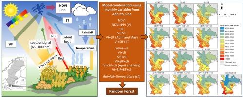
Estimation of district-level spring barley yield in southern Sweden using multi-source satellite data and random forest approach
Remote sensing observations and artificial intelligence algorithms have emerged as key components for crop yield estimation at various scales during the past decades. However, the utilization of multi-source satellite data and machine learning for estimating aggregated crop yield at the regional level in Europe has been only scarcely explored. Our study aims to bridge this research gap by focusing on the district-level spring barley yield estimation in southern Sweden from 2017 to 2022. We developed an estimation method with the random forest (RF) approach using four satellite-derived products along with two climate variables. These variables were used individually and in combinations as inputs for the RF approach. The results showed that vegetation indices (VIs) outperformed solar-induced chlorophyll fluorescence (SIF) in barley yield estimation, while combining VIs and SIF variables achieved the highest model performance (R2 = 0.77, RMSE = 488 kg/ha). The inclusion of climate variables generally had little added contributions to the model performance. Importantly, barley yield prediction could be achieved two months prior to harvest, using monthly VIs and SIF data from April and May. Our study demonstrated the feasibility of using freely accessible satellite data and the machine learning approach for estimating crop yield at the pan-European regional level. We expect that our proposed methodology can be extended to different crop types and regional-scale crop yield estimation in Europe, benefiting national and local authorities in making agricultural productivity decisions.
期刊介绍:
The International Journal of Applied Earth Observation and Geoinformation publishes original papers that utilize earth observation data for natural resource and environmental inventory and management. These data primarily originate from remote sensing platforms, including satellites and aircraft, supplemented by surface and subsurface measurements. Addressing natural resources such as forests, agricultural land, soils, and water, as well as environmental concerns like biodiversity, land degradation, and hazards, the journal explores conceptual and data-driven approaches. It covers geoinformation themes like capturing, databasing, visualization, interpretation, data quality, and spatial uncertainty.


 分享
分享
 求助内容:
求助内容: 应助结果提醒方式:
 扫码关注我们
