Jamie Smith, Anton Kast, Anton Geraschenko, Y. Jade Morton, Michael P. Brenner, Frank van Diggelen, Brian P. Williams
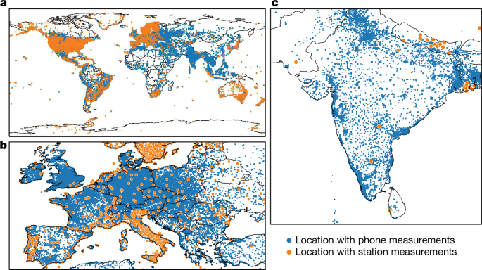
{"title":"用数百万部手机绘制电离层地图","authors":"Jamie Smith, Anton Kast, Anton Geraschenko, Y. Jade Morton, Michael P. Brenner, Frank van Diggelen, Brian P. Williams","doi":"10.1038/s41586-024-08072-x","DOIUrl":null,"url":null,"abstract":"The ionosphere is a layer of weakly ionized plasma bathed in Earth’s geomagnetic field extending about 50–1,500 kilometres above Earth1. The ionospheric total electron content varies in response to Earth’s space environment, interfering with Global Satellite Navigation System (GNSS) signals, resulting in one of the largest sources of error for position, navigation and timing services2. Networks of high-quality ground-based GNSS stations provide maps of ionospheric total electron content to correct these errors, but large spatiotemporal gaps in data from these stations mean that these maps may contain errors3. Here we demonstrate that a distributed network of noisy sensors—in the form of millions of Android phones—can fill in many of these gaps and double the measurement coverage, providing an accurate picture of the ionosphere in areas of the world underserved by conventional infrastructure. Using smartphone measurements, we resolve features such as plasma bubbles over India and South America, solar-storm-enhanced density over North America and a mid-latitude ionospheric trough over Europe. We also show that the resulting ionosphere maps can improve location accuracy, which is our primary aim. This work demonstrates the potential of using a large distributed network of smartphones as a powerful scientific instrument for monitoring Earth. Data from millions of smartphones are used to map the ionosphere in greater detail, leading to improved smartphone location accuracy, particularly in parts of the world with few monitoring stations.","PeriodicalId":18787,"journal":{"name":"Nature","volume":"635 8038","pages":"365-369"},"PeriodicalIF":56.1000,"publicationDate":"2024-11-13","publicationTypes":"Journal Article","fieldsOfStudy":null,"isOpenAccess":false,"openAccessPdf":"https://www.nature.com/articles/s41586-024-08072-x.pdf","citationCount":"0","resultStr":"{\"title\":\"Mapping the ionosphere with millions of phones\",\"authors\":\"Jamie Smith, Anton Kast, Anton Geraschenko, Y. Jade Morton, Michael P. Brenner, Frank van Diggelen, Brian P. Williams\",\"doi\":\"10.1038/s41586-024-08072-x\",\"DOIUrl\":null,\"url\":null,\"abstract\":\"The ionosphere is a layer of weakly ionized plasma bathed in Earth’s geomagnetic field extending about 50–1,500 kilometres above Earth1. The ionospheric total electron content varies in response to Earth’s space environment, interfering with Global Satellite Navigation System (GNSS) signals, resulting in one of the largest sources of error for position, navigation and timing services2. Networks of high-quality ground-based GNSS stations provide maps of ionospheric total electron content to correct these errors, but large spatiotemporal gaps in data from these stations mean that these maps may contain errors3. Here we demonstrate that a distributed network of noisy sensors—in the form of millions of Android phones—can fill in many of these gaps and double the measurement coverage, providing an accurate picture of the ionosphere in areas of the world underserved by conventional infrastructure. Using smartphone measurements, we resolve features such as plasma bubbles over India and South America, solar-storm-enhanced density over North America and a mid-latitude ionospheric trough over Europe. We also show that the resulting ionosphere maps can improve location accuracy, which is our primary aim. This work demonstrates the potential of using a large distributed network of smartphones as a powerful scientific instrument for monitoring Earth. Data from millions of smartphones are used to map the ionosphere in greater detail, leading to improved smartphone location accuracy, particularly in parts of the world with few monitoring stations.\",\"PeriodicalId\":18787,\"journal\":{\"name\":\"Nature\",\"volume\":\"635 8038\",\"pages\":\"365-369\"},\"PeriodicalIF\":56.1000,\"publicationDate\":\"2024-11-13\",\"publicationTypes\":\"Journal Article\",\"fieldsOfStudy\":null,\"isOpenAccess\":false,\"openAccessPdf\":\"https://www.nature.com/articles/s41586-024-08072-x.pdf\",\"citationCount\":\"0\",\"resultStr\":null,\"platform\":\"Semanticscholar\",\"paperid\":null,\"PeriodicalName\":\"Nature\",\"FirstCategoryId\":\"103\",\"ListUrlMain\":\"https://www.nature.com/articles/s41586-024-08072-x\",\"RegionNum\":1,\"RegionCategory\":\"综合性期刊\",\"ArticlePicture\":[],\"TitleCN\":null,\"AbstractTextCN\":null,\"PMCID\":null,\"EPubDate\":\"\",\"PubModel\":\"\",\"JCR\":\"Q1\",\"JCRName\":\"MULTIDISCIPLINARY SCIENCES\",\"Score\":null,\"Total\":0}","platform":"Semanticscholar","paperid":null,"PeriodicalName":"Nature","FirstCategoryId":"103","ListUrlMain":"https://www.nature.com/articles/s41586-024-08072-x","RegionNum":1,"RegionCategory":"综合性期刊","ArticlePicture":[],"TitleCN":null,"AbstractTextCN":null,"PMCID":null,"EPubDate":"","PubModel":"","JCR":"Q1","JCRName":"MULTIDISCIPLINARY SCIENCES","Score":null,"Total":0}
The ionosphere is a layer of weakly ionized plasma bathed in Earth’s geomagnetic field extending about 50–1,500 kilometres above Earth1. The ionospheric total electron content varies in response to Earth’s space environment, interfering with Global Satellite Navigation System (GNSS) signals, resulting in one of the largest sources of error for position, navigation and timing services2. Networks of high-quality ground-based GNSS stations provide maps of ionospheric total electron content to correct these errors, but large spatiotemporal gaps in data from these stations mean that these maps may contain errors3. Here we demonstrate that a distributed network of noisy sensors—in the form of millions of Android phones—can fill in many of these gaps and double the measurement coverage, providing an accurate picture of the ionosphere in areas of the world underserved by conventional infrastructure. Using smartphone measurements, we resolve features such as plasma bubbles over India and South America, solar-storm-enhanced density over North America and a mid-latitude ionospheric trough over Europe. We also show that the resulting ionosphere maps can improve location accuracy, which is our primary aim. This work demonstrates the potential of using a large distributed network of smartphones as a powerful scientific instrument for monitoring Earth. Data from millions of smartphones are used to map the ionosphere in greater detail, leading to improved smartphone location accuracy, particularly in parts of the world with few monitoring stations.
期刊介绍:
Nature is a prestigious international journal that publishes peer-reviewed research in various scientific and technological fields. The selection of articles is based on criteria such as originality, importance, interdisciplinary relevance, timeliness, accessibility, elegance, and surprising conclusions. In addition to showcasing significant scientific advances, Nature delivers rapid, authoritative, insightful news, and interpretation of current and upcoming trends impacting science, scientists, and the broader public. The journal serves a dual purpose: firstly, to promptly share noteworthy scientific advances and foster discussions among scientists, and secondly, to ensure the swift dissemination of scientific results globally, emphasizing their significance for knowledge, culture, and daily life.




 京公网安备 11010802042870号
京ICP备2023020795号-1
京公网安备 11010802042870号
京ICP备2023020795号-1

 分享
分享
 求助内容:
求助内容: 应助结果提醒方式:
 扫码关注我们
