{"title":"绘制泰国湄南河下游流域气候变化下农业经济损失的洪水风险曲线","authors":"Aakanchya Budhathoki, Tomohiro Tanaka, Yasuto Tachikawa","doi":"10.1111/jfr3.13031","DOIUrl":null,"url":null,"abstract":"<p>Rice is a major agricultural crop in Thailand, while paddy fields near river lines are exposed to high flood risk. This study assesses rice exposure and economic flood risk under future climate in the Lower Chao Phraya River Basin, Thailand. To encompass various flood events, this study estimates the frequency of rice economic damage by employing a large ensemble climate projection dataset based on database for Policy Decision making for Future climate change (d4PDF). Results show that, in the 4-K warmer climate, the 100-year exposed cultivation area and duration will increase approximately by 1.2–1.4 and 1.1–1.2 times, respectively. Decreased rice production is evaluated as monetary damage through several fragility curves. The economic damage by the 2011 flooding is estimated as 11.25 billion Thai Baht, while the estimation varies from the fragility curves employed. In the 4 K warmer climate, regardless of the fragility curves, 100-year rice damage is projected to increase by 1.2–1.4 times. The 2011 flooding is larger than all 3000-year simulations in the past climate, whereas extreme events in the 4 K warmer climate showed higher damage than the 2011 flooding, indicating that agricultural damage corresponding to the 2011 flooding may occur more frequently in the future climate.</p>","PeriodicalId":49294,"journal":{"name":"Journal of Flood Risk Management","volume":"17 4","pages":""},"PeriodicalIF":3.0000,"publicationDate":"2024-09-04","publicationTypes":"Journal Article","fieldsOfStudy":null,"isOpenAccess":false,"openAccessPdf":"https://onlinelibrary.wiley.com/doi/epdf/10.1111/jfr3.13031","citationCount":"0","resultStr":"{\"title\":\"Developing flood risk curves of agricultural economic damage under climate change in the Lower Chao Phraya River Basin, Thailand\",\"authors\":\"Aakanchya Budhathoki, Tomohiro Tanaka, Yasuto Tachikawa\",\"doi\":\"10.1111/jfr3.13031\",\"DOIUrl\":null,\"url\":null,\"abstract\":\"<p>Rice is a major agricultural crop in Thailand, while paddy fields near river lines are exposed to high flood risk. This study assesses rice exposure and economic flood risk under future climate in the Lower Chao Phraya River Basin, Thailand. To encompass various flood events, this study estimates the frequency of rice economic damage by employing a large ensemble climate projection dataset based on database for Policy Decision making for Future climate change (d4PDF). Results show that, in the 4-K warmer climate, the 100-year exposed cultivation area and duration will increase approximately by 1.2–1.4 and 1.1–1.2 times, respectively. Decreased rice production is evaluated as monetary damage through several fragility curves. The economic damage by the 2011 flooding is estimated as 11.25 billion Thai Baht, while the estimation varies from the fragility curves employed. In the 4 K warmer climate, regardless of the fragility curves, 100-year rice damage is projected to increase by 1.2–1.4 times. The 2011 flooding is larger than all 3000-year simulations in the past climate, whereas extreme events in the 4 K warmer climate showed higher damage than the 2011 flooding, indicating that agricultural damage corresponding to the 2011 flooding may occur more frequently in the future climate.</p>\",\"PeriodicalId\":49294,\"journal\":{\"name\":\"Journal of Flood Risk Management\",\"volume\":\"17 4\",\"pages\":\"\"},\"PeriodicalIF\":3.0000,\"publicationDate\":\"2024-09-04\",\"publicationTypes\":\"Journal Article\",\"fieldsOfStudy\":null,\"isOpenAccess\":false,\"openAccessPdf\":\"https://onlinelibrary.wiley.com/doi/epdf/10.1111/jfr3.13031\",\"citationCount\":\"0\",\"resultStr\":null,\"platform\":\"Semanticscholar\",\"paperid\":null,\"PeriodicalName\":\"Journal of Flood Risk Management\",\"FirstCategoryId\":\"93\",\"ListUrlMain\":\"https://onlinelibrary.wiley.com/doi/10.1111/jfr3.13031\",\"RegionNum\":3,\"RegionCategory\":\"环境科学与生态学\",\"ArticlePicture\":[],\"TitleCN\":null,\"AbstractTextCN\":null,\"PMCID\":null,\"EPubDate\":\"\",\"PubModel\":\"\",\"JCR\":\"Q2\",\"JCRName\":\"ENVIRONMENTAL SCIENCES\",\"Score\":null,\"Total\":0}","platform":"Semanticscholar","paperid":null,"PeriodicalName":"Journal of Flood Risk Management","FirstCategoryId":"93","ListUrlMain":"https://onlinelibrary.wiley.com/doi/10.1111/jfr3.13031","RegionNum":3,"RegionCategory":"环境科学与生态学","ArticlePicture":[],"TitleCN":null,"AbstractTextCN":null,"PMCID":null,"EPubDate":"","PubModel":"","JCR":"Q2","JCRName":"ENVIRONMENTAL SCIENCES","Score":null,"Total":0}
Developing flood risk curves of agricultural economic damage under climate change in the Lower Chao Phraya River Basin, Thailand
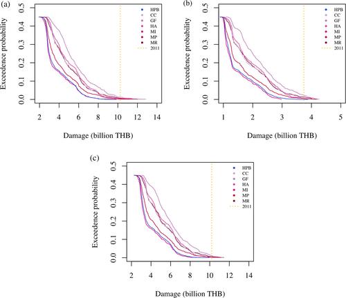
Rice is a major agricultural crop in Thailand, while paddy fields near river lines are exposed to high flood risk. This study assesses rice exposure and economic flood risk under future climate in the Lower Chao Phraya River Basin, Thailand. To encompass various flood events, this study estimates the frequency of rice economic damage by employing a large ensemble climate projection dataset based on database for Policy Decision making for Future climate change (d4PDF). Results show that, in the 4-K warmer climate, the 100-year exposed cultivation area and duration will increase approximately by 1.2–1.4 and 1.1–1.2 times, respectively. Decreased rice production is evaluated as monetary damage through several fragility curves. The economic damage by the 2011 flooding is estimated as 11.25 billion Thai Baht, while the estimation varies from the fragility curves employed. In the 4 K warmer climate, regardless of the fragility curves, 100-year rice damage is projected to increase by 1.2–1.4 times. The 2011 flooding is larger than all 3000-year simulations in the past climate, whereas extreme events in the 4 K warmer climate showed higher damage than the 2011 flooding, indicating that agricultural damage corresponding to the 2011 flooding may occur more frequently in the future climate.
期刊介绍:
Journal of Flood Risk Management provides an international platform for knowledge sharing in all areas related to flood risk. Its explicit aim is to disseminate ideas across the range of disciplines where flood related research is carried out and it provides content ranging from leading edge academic papers to applied content with the practitioner in mind.
Readers and authors come from a wide background and include hydrologists, meteorologists, geographers, geomorphologists, conservationists, civil engineers, social scientists, policy makers, insurers and practitioners. They share an interest in managing the complex interactions between the many skills and disciplines that underpin the management of flood risk across the world.


 分享
分享
 求助内容:
求助内容: 应助结果提醒方式:
 扫码关注我们
