Sesar Prabu Dwi Sriyanto, Arif Nurokhim, Teguh Sulistian, Indra Gunawan, Rizki Iman Sari, Brilian Tatag Samapta, Iman Fatchurochman, Fajar Triady Mugiarto, Rifqi Muhammad Harrys
{"title":"基于不同数字高程模型(DEM)数据集和断层源模型的印尼爪哇Cilegon工业区海啸危害评估","authors":"Sesar Prabu Dwi Sriyanto, Arif Nurokhim, Teguh Sulistian, Indra Gunawan, Rizki Iman Sari, Brilian Tatag Samapta, Iman Fatchurochman, Fajar Triady Mugiarto, Rifqi Muhammad Harrys","doi":"10.1007/s12517-024-12133-w","DOIUrl":null,"url":null,"abstract":"<p>Sumatra-Java megathrust has been a host of six earthquake-triggered tsunamis in recent decades, which caused severe damage. Cilegon industrial area is a tsunami-prone zone since it is located on the Sunda Strait coast, facing a possibility of large-magnitude earthquake occurrence in the transition zone of Sumatra and Java megathrust. In this study, we assess the tsunami hazard in this area using a deterministic approach from a worst-case earthquake scenario (Mw 8.9). The assessment was done using numerical tsunami modeling, considering various fault source models and digital elevation model (DEM) datasets to accommodate the uncertainty of those factors in the modeling. Two source models (non-uniform and uniform fault slips) and three DEM datasets (global, regional, and local data) were employed. Uniform slip affected the smaller maximum tsunami amplitude than the non-uniform slip, but the travel time from these two source models is similar. Differences in water depth and slope bathymetry profile also strongly influence the tsunami propagation characteristics, particularly in the finest layer model. Generally, the Cilegon coast is consistently hit by up to 9 m of tsunami height from all used scenarios. The estimated tsunami arrival time is more than 60 min, providing enough time for the coastal community to evacuate to the higher ground level. However, the Cilegon industrial area is still categorized as highly hazardous since the tsunami strike can damage industrial buildings, infrastructure, and factory equipment, leading to economic losses.</p>","PeriodicalId":476,"journal":{"name":"Arabian Journal of Geosciences","volume":"17 12","pages":""},"PeriodicalIF":1.8270,"publicationDate":"2024-12-02","publicationTypes":"Journal Article","fieldsOfStudy":null,"isOpenAccess":false,"openAccessPdf":"","citationCount":"0","resultStr":"{\"title\":\"Tsunami hazard assessment for the Cilegon industrial zone, Java, Indonesia, by considering various digital elevation model (DEM) datasets and fault source models\",\"authors\":\"Sesar Prabu Dwi Sriyanto, Arif Nurokhim, Teguh Sulistian, Indra Gunawan, Rizki Iman Sari, Brilian Tatag Samapta, Iman Fatchurochman, Fajar Triady Mugiarto, Rifqi Muhammad Harrys\",\"doi\":\"10.1007/s12517-024-12133-w\",\"DOIUrl\":null,\"url\":null,\"abstract\":\"<p>Sumatra-Java megathrust has been a host of six earthquake-triggered tsunamis in recent decades, which caused severe damage. Cilegon industrial area is a tsunami-prone zone since it is located on the Sunda Strait coast, facing a possibility of large-magnitude earthquake occurrence in the transition zone of Sumatra and Java megathrust. In this study, we assess the tsunami hazard in this area using a deterministic approach from a worst-case earthquake scenario (Mw 8.9). The assessment was done using numerical tsunami modeling, considering various fault source models and digital elevation model (DEM) datasets to accommodate the uncertainty of those factors in the modeling. Two source models (non-uniform and uniform fault slips) and three DEM datasets (global, regional, and local data) were employed. Uniform slip affected the smaller maximum tsunami amplitude than the non-uniform slip, but the travel time from these two source models is similar. Differences in water depth and slope bathymetry profile also strongly influence the tsunami propagation characteristics, particularly in the finest layer model. Generally, the Cilegon coast is consistently hit by up to 9 m of tsunami height from all used scenarios. The estimated tsunami arrival time is more than 60 min, providing enough time for the coastal community to evacuate to the higher ground level. However, the Cilegon industrial area is still categorized as highly hazardous since the tsunami strike can damage industrial buildings, infrastructure, and factory equipment, leading to economic losses.</p>\",\"PeriodicalId\":476,\"journal\":{\"name\":\"Arabian Journal of Geosciences\",\"volume\":\"17 12\",\"pages\":\"\"},\"PeriodicalIF\":1.8270,\"publicationDate\":\"2024-12-02\",\"publicationTypes\":\"Journal Article\",\"fieldsOfStudy\":null,\"isOpenAccess\":false,\"openAccessPdf\":\"\",\"citationCount\":\"0\",\"resultStr\":null,\"platform\":\"Semanticscholar\",\"paperid\":null,\"PeriodicalName\":\"Arabian Journal of Geosciences\",\"FirstCategoryId\":\"1085\",\"ListUrlMain\":\"https://link.springer.com/article/10.1007/s12517-024-12133-w\",\"RegionNum\":0,\"RegionCategory\":null,\"ArticlePicture\":[],\"TitleCN\":null,\"AbstractTextCN\":null,\"PMCID\":null,\"EPubDate\":\"\",\"PubModel\":\"\",\"JCR\":\"Q2\",\"JCRName\":\"Earth and Planetary Sciences\",\"Score\":null,\"Total\":0}","platform":"Semanticscholar","paperid":null,"PeriodicalName":"Arabian Journal of Geosciences","FirstCategoryId":"1085","ListUrlMain":"https://link.springer.com/article/10.1007/s12517-024-12133-w","RegionNum":0,"RegionCategory":null,"ArticlePicture":[],"TitleCN":null,"AbstractTextCN":null,"PMCID":null,"EPubDate":"","PubModel":"","JCR":"Q2","JCRName":"Earth and Planetary Sciences","Score":null,"Total":0}
Tsunami hazard assessment for the Cilegon industrial zone, Java, Indonesia, by considering various digital elevation model (DEM) datasets and fault source models
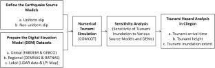
Sumatra-Java megathrust has been a host of six earthquake-triggered tsunamis in recent decades, which caused severe damage. Cilegon industrial area is a tsunami-prone zone since it is located on the Sunda Strait coast, facing a possibility of large-magnitude earthquake occurrence in the transition zone of Sumatra and Java megathrust. In this study, we assess the tsunami hazard in this area using a deterministic approach from a worst-case earthquake scenario (Mw 8.9). The assessment was done using numerical tsunami modeling, considering various fault source models and digital elevation model (DEM) datasets to accommodate the uncertainty of those factors in the modeling. Two source models (non-uniform and uniform fault slips) and three DEM datasets (global, regional, and local data) were employed. Uniform slip affected the smaller maximum tsunami amplitude than the non-uniform slip, but the travel time from these two source models is similar. Differences in water depth and slope bathymetry profile also strongly influence the tsunami propagation characteristics, particularly in the finest layer model. Generally, the Cilegon coast is consistently hit by up to 9 m of tsunami height from all used scenarios. The estimated tsunami arrival time is more than 60 min, providing enough time for the coastal community to evacuate to the higher ground level. However, the Cilegon industrial area is still categorized as highly hazardous since the tsunami strike can damage industrial buildings, infrastructure, and factory equipment, leading to economic losses.
期刊介绍:
The Arabian Journal of Geosciences is the official journal of the Saudi Society for Geosciences and publishes peer-reviewed original and review articles on the entire range of Earth Science themes, focused on, but not limited to, those that have regional significance to the Middle East and the Euro-Mediterranean Zone.
Key topics therefore include; geology, hydrogeology, earth system science, petroleum sciences, geophysics, seismology and crustal structures, tectonics, sedimentology, palaeontology, metamorphic and igneous petrology, natural hazards, environmental sciences and sustainable development, geoarchaeology, geomorphology, paleo-environment studies, oceanography, atmospheric sciences, GIS and remote sensing, geodesy, mineralogy, volcanology, geochemistry and metallogenesis.


 分享
分享
 求助内容:
求助内容: 应助结果提醒方式:
 扫码关注我们
