{"title":"锡金喜马拉雅冰川湖的危害和风险建模:综合危害评估的定性和定量方法","authors":"Deepali Gaikwad , Reet Kamal Tiwari , Mahesh Kumar , Supratim Guha","doi":"10.1016/j.geomorph.2024.109577","DOIUrl":null,"url":null,"abstract":"<div><div>Glacial lakes are prone to outburst due to breaching or overtopping of natural dams, leading to Glacial Lake Outburst Floods (GLOFs). These floods represent a substantial danger to communities downstream and essential infrastructure. To address this issue, it is crucial to investigate certain key factors, including gaining insight into the dynamics of glacial lakes, identifying dangerous ones, and assessing the associated level of risk. In this study, we scrutinized the temporal changes of glacial lakes in the Sikkim Himalaya for the years 1990, 2000, 2010, and 2020 using Landsat satellite imageries. Furthermore, we performed a hazard assessment of GLOFs in terms of both qualitatively, and quantitatively assessment. Moreover, qualitative evaluation involves seven external triggers and quantitative assessment employed by utilizing the Fuzzy Analytical Hierarchy Process (FAHP) method, considering six causative factors. Finally, we modelled the degree of risk associated with glacial lakes by quantifying downstream impacts with the help of GIS-based Stochastic Inundation Monte-Carlo Least Cost Path model (MC-LCP). The findings revealed that the number of glacial lakes increased from 309 to 440, with a total area expansion from 22.83 km<sup>2</sup> to 30.71 km<sup>2</sup> over the 30-year period. Also, among the 51 glacial lakes susceptible to GLOFs, seven lakes were classified as highly hazardous and another six were deemed to pose high risk. Overall this study contributes to planning field investigations and developing effective mitigation strategies to minimize the significant socio-economic losses caused by GLOFs in the Sikkim Himalaya.</div></div>","PeriodicalId":55115,"journal":{"name":"Geomorphology","volume":"471 ","pages":"Article 109577"},"PeriodicalIF":3.1000,"publicationDate":"2025-02-15","publicationTypes":"Journal Article","fieldsOfStudy":null,"isOpenAccess":false,"openAccessPdf":"","citationCount":"0","resultStr":"{\"title\":\"Hazard, and risk modelling of glacial lakes in the Sikkim Himalaya: Integrating qualitative and quantitative approaches for hazard assessment\",\"authors\":\"Deepali Gaikwad , Reet Kamal Tiwari , Mahesh Kumar , Supratim Guha\",\"doi\":\"10.1016/j.geomorph.2024.109577\",\"DOIUrl\":null,\"url\":null,\"abstract\":\"<div><div>Glacial lakes are prone to outburst due to breaching or overtopping of natural dams, leading to Glacial Lake Outburst Floods (GLOFs). These floods represent a substantial danger to communities downstream and essential infrastructure. To address this issue, it is crucial to investigate certain key factors, including gaining insight into the dynamics of glacial lakes, identifying dangerous ones, and assessing the associated level of risk. In this study, we scrutinized the temporal changes of glacial lakes in the Sikkim Himalaya for the years 1990, 2000, 2010, and 2020 using Landsat satellite imageries. Furthermore, we performed a hazard assessment of GLOFs in terms of both qualitatively, and quantitatively assessment. Moreover, qualitative evaluation involves seven external triggers and quantitative assessment employed by utilizing the Fuzzy Analytical Hierarchy Process (FAHP) method, considering six causative factors. Finally, we modelled the degree of risk associated with glacial lakes by quantifying downstream impacts with the help of GIS-based Stochastic Inundation Monte-Carlo Least Cost Path model (MC-LCP). The findings revealed that the number of glacial lakes increased from 309 to 440, with a total area expansion from 22.83 km<sup>2</sup> to 30.71 km<sup>2</sup> over the 30-year period. Also, among the 51 glacial lakes susceptible to GLOFs, seven lakes were classified as highly hazardous and another six were deemed to pose high risk. Overall this study contributes to planning field investigations and developing effective mitigation strategies to minimize the significant socio-economic losses caused by GLOFs in the Sikkim Himalaya.</div></div>\",\"PeriodicalId\":55115,\"journal\":{\"name\":\"Geomorphology\",\"volume\":\"471 \",\"pages\":\"Article 109577\"},\"PeriodicalIF\":3.1000,\"publicationDate\":\"2025-02-15\",\"publicationTypes\":\"Journal Article\",\"fieldsOfStudy\":null,\"isOpenAccess\":false,\"openAccessPdf\":\"\",\"citationCount\":\"0\",\"resultStr\":null,\"platform\":\"Semanticscholar\",\"paperid\":null,\"PeriodicalName\":\"Geomorphology\",\"FirstCategoryId\":\"89\",\"ListUrlMain\":\"https://www.sciencedirect.com/science/article/pii/S0169555X24005294\",\"RegionNum\":2,\"RegionCategory\":\"地球科学\",\"ArticlePicture\":[],\"TitleCN\":null,\"AbstractTextCN\":null,\"PMCID\":null,\"EPubDate\":\"2024/12/16 0:00:00\",\"PubModel\":\"Epub\",\"JCR\":\"Q2\",\"JCRName\":\"GEOGRAPHY, PHYSICAL\",\"Score\":null,\"Total\":0}","platform":"Semanticscholar","paperid":null,"PeriodicalName":"Geomorphology","FirstCategoryId":"89","ListUrlMain":"https://www.sciencedirect.com/science/article/pii/S0169555X24005294","RegionNum":2,"RegionCategory":"地球科学","ArticlePicture":[],"TitleCN":null,"AbstractTextCN":null,"PMCID":null,"EPubDate":"2024/12/16 0:00:00","PubModel":"Epub","JCR":"Q2","JCRName":"GEOGRAPHY, PHYSICAL","Score":null,"Total":0}
Hazard, and risk modelling of glacial lakes in the Sikkim Himalaya: Integrating qualitative and quantitative approaches for hazard assessment
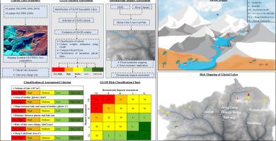
Glacial lakes are prone to outburst due to breaching or overtopping of natural dams, leading to Glacial Lake Outburst Floods (GLOFs). These floods represent a substantial danger to communities downstream and essential infrastructure. To address this issue, it is crucial to investigate certain key factors, including gaining insight into the dynamics of glacial lakes, identifying dangerous ones, and assessing the associated level of risk. In this study, we scrutinized the temporal changes of glacial lakes in the Sikkim Himalaya for the years 1990, 2000, 2010, and 2020 using Landsat satellite imageries. Furthermore, we performed a hazard assessment of GLOFs in terms of both qualitatively, and quantitatively assessment. Moreover, qualitative evaluation involves seven external triggers and quantitative assessment employed by utilizing the Fuzzy Analytical Hierarchy Process (FAHP) method, considering six causative factors. Finally, we modelled the degree of risk associated with glacial lakes by quantifying downstream impacts with the help of GIS-based Stochastic Inundation Monte-Carlo Least Cost Path model (MC-LCP). The findings revealed that the number of glacial lakes increased from 309 to 440, with a total area expansion from 22.83 km2 to 30.71 km2 over the 30-year period. Also, among the 51 glacial lakes susceptible to GLOFs, seven lakes were classified as highly hazardous and another six were deemed to pose high risk. Overall this study contributes to planning field investigations and developing effective mitigation strategies to minimize the significant socio-economic losses caused by GLOFs in the Sikkim Himalaya.
期刊介绍:
Our journal''s scope includes geomorphic themes of: tectonics and regional structure; glacial processes and landforms; fluvial sequences, Quaternary environmental change and dating; fluvial processes and landforms; mass movement, slopes and periglacial processes; hillslopes and soil erosion; weathering, karst and soils; aeolian processes and landforms, coastal dunes and arid environments; coastal and marine processes, estuaries and lakes; modelling, theoretical and quantitative geomorphology; DEM, GIS and remote sensing methods and applications; hazards, applied and planetary geomorphology; and volcanics.




 京公网安备 11010802042870号
京ICP备2023020795号-1
京公网安备 11010802042870号
京ICP备2023020795号-1

 分享
分享
 求助内容:
求助内容: 应助结果提醒方式:
 扫码关注我们
