Matthias Beyer, Alberto Iraheta, Malkin Gerchow, Kathrin Kuehnhammer, Ana Claudia Callau-Beyer, Paul Koeniger, David Dubbert, Maren Dubbert, Ricardo Sánchez-Murillo, Christian Birkel
{"title":"基于无人机的地表温度和植被指数解释和预测热带干旱森林土壤水分同位素的空间格局","authors":"Matthias Beyer, Alberto Iraheta, Malkin Gerchow, Kathrin Kuehnhammer, Ana Claudia Callau-Beyer, Paul Koeniger, David Dubbert, Maren Dubbert, Ricardo Sánchez-Murillo, Christian Birkel","doi":"10.1029/2024wr037294","DOIUrl":null,"url":null,"abstract":"The spatial variation of soil water isotopes (SWI)—representing the baseline for investigating root water uptake (RWU) depths with water stable isotope techniques—has rarely been investigated. Here, we use spatial SWI depth profile sampling in combination with unmanned aerial vehicle (UAV) based land surface temperature estimates and vegetation indices (VI) in order to improving process understanding of the relationships between the spatial variability of soil water content and soil water isotope patterns with canopy status, represented in the form of VI. We carried out a spatial sampling of 10 SWI depth profiles in a tropical dry forest. UAV data were collected and analyzed to obtain detailed characterization of soil temperature and canopy status. We then performed a statistical analysis between the VI and land surface temperatures with soil water content and SWI values at different spatial resolutions (3 cm–5 m). Best relationships were used for generating soil water isoscapes for the entire study area. Results suggest that soil water content and SWI values are strongly mediated by canopy parameters (VI). Various VI correlate strongly with soil water content and SWI values across all depths. SWI at the surface depend on land surface temperature (<i>R</i><sup>2</sup> of 0.66 for δ<sup>18</sup>O and 0.64 for δ<sup>2</sup>H). Strongest overall correlations were found at a spatial resolution of 0.5 m. We speculate that this might be the ideal resolution for spatially characterizing SWI patterns and investigate RWU in tropical dry forest environments. Supporting spatial analyses of SWI with UAV-based approaches might be a future avenue for improving the spatial representation and credibility of such studies.","PeriodicalId":23799,"journal":{"name":"Water Resources Research","volume":"10 1","pages":""},"PeriodicalIF":5.0000,"publicationDate":"2025-02-14","publicationTypes":"Journal Article","fieldsOfStudy":null,"isOpenAccess":false,"openAccessPdf":"","citationCount":"0","resultStr":"{\"title\":\"UAV-Based Land Surface Temperatures and Vegetation Indices Explain and Predict Spatial Patterns of Soil Water Isotopes in a Tropical Dry Forest\",\"authors\":\"Matthias Beyer, Alberto Iraheta, Malkin Gerchow, Kathrin Kuehnhammer, Ana Claudia Callau-Beyer, Paul Koeniger, David Dubbert, Maren Dubbert, Ricardo Sánchez-Murillo, Christian Birkel\",\"doi\":\"10.1029/2024wr037294\",\"DOIUrl\":null,\"url\":null,\"abstract\":\"The spatial variation of soil water isotopes (SWI)—representing the baseline for investigating root water uptake (RWU) depths with water stable isotope techniques—has rarely been investigated. Here, we use spatial SWI depth profile sampling in combination with unmanned aerial vehicle (UAV) based land surface temperature estimates and vegetation indices (VI) in order to improving process understanding of the relationships between the spatial variability of soil water content and soil water isotope patterns with canopy status, represented in the form of VI. We carried out a spatial sampling of 10 SWI depth profiles in a tropical dry forest. UAV data were collected and analyzed to obtain detailed characterization of soil temperature and canopy status. We then performed a statistical analysis between the VI and land surface temperatures with soil water content and SWI values at different spatial resolutions (3 cm–5 m). Best relationships were used for generating soil water isoscapes for the entire study area. Results suggest that soil water content and SWI values are strongly mediated by canopy parameters (VI). Various VI correlate strongly with soil water content and SWI values across all depths. SWI at the surface depend on land surface temperature (<i>R</i><sup>2</sup> of 0.66 for δ<sup>18</sup>O and 0.64 for δ<sup>2</sup>H). Strongest overall correlations were found at a spatial resolution of 0.5 m. We speculate that this might be the ideal resolution for spatially characterizing SWI patterns and investigate RWU in tropical dry forest environments. Supporting spatial analyses of SWI with UAV-based approaches might be a future avenue for improving the spatial representation and credibility of such studies.\",\"PeriodicalId\":23799,\"journal\":{\"name\":\"Water Resources Research\",\"volume\":\"10 1\",\"pages\":\"\"},\"PeriodicalIF\":5.0000,\"publicationDate\":\"2025-02-14\",\"publicationTypes\":\"Journal Article\",\"fieldsOfStudy\":null,\"isOpenAccess\":false,\"openAccessPdf\":\"\",\"citationCount\":\"0\",\"resultStr\":null,\"platform\":\"Semanticscholar\",\"paperid\":null,\"PeriodicalName\":\"Water Resources Research\",\"FirstCategoryId\":\"89\",\"ListUrlMain\":\"https://doi.org/10.1029/2024wr037294\",\"RegionNum\":1,\"RegionCategory\":\"地球科学\",\"ArticlePicture\":[],\"TitleCN\":null,\"AbstractTextCN\":null,\"PMCID\":null,\"EPubDate\":\"\",\"PubModel\":\"\",\"JCR\":\"Q2\",\"JCRName\":\"ENVIRONMENTAL SCIENCES\",\"Score\":null,\"Total\":0}","platform":"Semanticscholar","paperid":null,"PeriodicalName":"Water Resources Research","FirstCategoryId":"89","ListUrlMain":"https://doi.org/10.1029/2024wr037294","RegionNum":1,"RegionCategory":"地球科学","ArticlePicture":[],"TitleCN":null,"AbstractTextCN":null,"PMCID":null,"EPubDate":"","PubModel":"","JCR":"Q2","JCRName":"ENVIRONMENTAL SCIENCES","Score":null,"Total":0}
UAV-Based Land Surface Temperatures and Vegetation Indices Explain and Predict Spatial Patterns of Soil Water Isotopes in a Tropical Dry Forest
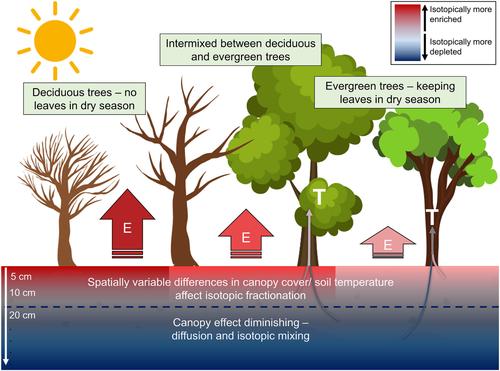
The spatial variation of soil water isotopes (SWI)—representing the baseline for investigating root water uptake (RWU) depths with water stable isotope techniques—has rarely been investigated. Here, we use spatial SWI depth profile sampling in combination with unmanned aerial vehicle (UAV) based land surface temperature estimates and vegetation indices (VI) in order to improving process understanding of the relationships between the spatial variability of soil water content and soil water isotope patterns with canopy status, represented in the form of VI. We carried out a spatial sampling of 10 SWI depth profiles in a tropical dry forest. UAV data were collected and analyzed to obtain detailed characterization of soil temperature and canopy status. We then performed a statistical analysis between the VI and land surface temperatures with soil water content and SWI values at different spatial resolutions (3 cm–5 m). Best relationships were used for generating soil water isoscapes for the entire study area. Results suggest that soil water content and SWI values are strongly mediated by canopy parameters (VI). Various VI correlate strongly with soil water content and SWI values across all depths. SWI at the surface depend on land surface temperature (R2 of 0.66 for δ18O and 0.64 for δ2H). Strongest overall correlations were found at a spatial resolution of 0.5 m. We speculate that this might be the ideal resolution for spatially characterizing SWI patterns and investigate RWU in tropical dry forest environments. Supporting spatial analyses of SWI with UAV-based approaches might be a future avenue for improving the spatial representation and credibility of such studies.
期刊介绍:
Water Resources Research (WRR) is an interdisciplinary journal that focuses on hydrology and water resources. It publishes original research in the natural and social sciences of water. It emphasizes the role of water in the Earth system, including physical, chemical, biological, and ecological processes in water resources research and management, including social, policy, and public health implications. It encompasses observational, experimental, theoretical, analytical, numerical, and data-driven approaches that advance the science of water and its management. Submissions are evaluated for their novelty, accuracy, significance, and broader implications of the findings.


 分享
分享
 求助内容:
求助内容: 应助结果提醒方式:
 扫码关注我们
