Mohammad Mehdi Rasouli , Hamed Ketabchi , Davood Mahmoodzadeh
{"title":"基于耦合模拟方法的河流-湿地-含水层区域系统地下水-地表水相互作用","authors":"Mohammad Mehdi Rasouli , Hamed Ketabchi , Davood Mahmoodzadeh","doi":"10.1016/j.jhydrol.2025.133006","DOIUrl":null,"url":null,"abstract":"<div><div>Assessing the interaction between surface water (SW) and groundwater (GW) is crucial to managing water resources effectively and efficiently. It is important to consider all SW-GW factors to assess SW-GW interaction accurately using models. In this study, a coupled model was developed for configuring SW-GW interaction at the regional watershed scale. Through coupled MODFLOW and OWHM (MF-OWHM), simulations were performed to show interaction effects and spatiotemporal variability. The developed methodology was applied to a real case study in Iran’s northwest to quantify the interaction between the Gadar river and Dorgeh wetland with the Naghadeh aquifer. The MF-OWHM adequately simulated the groundwater level (GWL) for the calibration (2001–2011, R<sup>2</sup> = 0.84, RMSE = 0.61 m) and validation (2012–2017, R<sup>2</sup> = 0.78, RMSE = 0.89 m) periods. The results showed that wetland inflow is mostly from surface water (66.6 %), whereas groundwater is minimal (1.6 %). However, the decline in GWL has led to a reduction in the wetland stage, therefore the wetland stage can serve as an indicator of GWL. The river recharges (43.29 MCM) and drains the aquifer (29.2 MCM) along its path. Examining several hydrological scenarios, it was found that transferring water from the river (0.2 MCM per day) and reducing the groundwater withdrawals (up to 100 %) near the wetland can prevent wetland drying. Conversely, scenarios involving changes in land use upstream of the wetland, dam construction, and increasing withdrawals (up to 100 %) dry the wetland. Changes at the local scale in the SW only affected its local condition while these changes altered the GWL throughout the aquifer (−6.3 to + 3.8 m). Based on these results, SW-GW water resources should be exploited and managed in a way that considers the interactions for sustainable water use.</div></div>","PeriodicalId":362,"journal":{"name":"Journal of Hydrology","volume":"656 ","pages":"Article 133006"},"PeriodicalIF":7.3000,"publicationDate":"2025-08-01","publicationTypes":"Journal Article","fieldsOfStudy":null,"isOpenAccess":false,"openAccessPdf":"","citationCount":"0","resultStr":"{\"title\":\"Groundwater-surface water interaction in a river-wetland-aquifer regional system using a coupled simulation-based approach\",\"authors\":\"Mohammad Mehdi Rasouli , Hamed Ketabchi , Davood Mahmoodzadeh\",\"doi\":\"10.1016/j.jhydrol.2025.133006\",\"DOIUrl\":null,\"url\":null,\"abstract\":\"<div><div>Assessing the interaction between surface water (SW) and groundwater (GW) is crucial to managing water resources effectively and efficiently. It is important to consider all SW-GW factors to assess SW-GW interaction accurately using models. In this study, a coupled model was developed for configuring SW-GW interaction at the regional watershed scale. Through coupled MODFLOW and OWHM (MF-OWHM), simulations were performed to show interaction effects and spatiotemporal variability. The developed methodology was applied to a real case study in Iran’s northwest to quantify the interaction between the Gadar river and Dorgeh wetland with the Naghadeh aquifer. The MF-OWHM adequately simulated the groundwater level (GWL) for the calibration (2001–2011, R<sup>2</sup> = 0.84, RMSE = 0.61 m) and validation (2012–2017, R<sup>2</sup> = 0.78, RMSE = 0.89 m) periods. The results showed that wetland inflow is mostly from surface water (66.6 %), whereas groundwater is minimal (1.6 %). However, the decline in GWL has led to a reduction in the wetland stage, therefore the wetland stage can serve as an indicator of GWL. The river recharges (43.29 MCM) and drains the aquifer (29.2 MCM) along its path. Examining several hydrological scenarios, it was found that transferring water from the river (0.2 MCM per day) and reducing the groundwater withdrawals (up to 100 %) near the wetland can prevent wetland drying. Conversely, scenarios involving changes in land use upstream of the wetland, dam construction, and increasing withdrawals (up to 100 %) dry the wetland. Changes at the local scale in the SW only affected its local condition while these changes altered the GWL throughout the aquifer (−6.3 to + 3.8 m). Based on these results, SW-GW water resources should be exploited and managed in a way that considers the interactions for sustainable water use.</div></div>\",\"PeriodicalId\":362,\"journal\":{\"name\":\"Journal of Hydrology\",\"volume\":\"656 \",\"pages\":\"Article 133006\"},\"PeriodicalIF\":7.3000,\"publicationDate\":\"2025-08-01\",\"publicationTypes\":\"Journal Article\",\"fieldsOfStudy\":null,\"isOpenAccess\":false,\"openAccessPdf\":\"\",\"citationCount\":\"0\",\"resultStr\":null,\"platform\":\"Semanticscholar\",\"paperid\":null,\"PeriodicalName\":\"Journal of Hydrology\",\"FirstCategoryId\":\"89\",\"ListUrlMain\":\"https://www.sciencedirect.com/science/article/pii/S0022169425003440\",\"RegionNum\":1,\"RegionCategory\":\"地球科学\",\"ArticlePicture\":[],\"TitleCN\":null,\"AbstractTextCN\":null,\"PMCID\":null,\"EPubDate\":\"2025/3/4 0:00:00\",\"PubModel\":\"Epub\",\"JCR\":\"Q1\",\"JCRName\":\"ENGINEERING, CIVIL\",\"Score\":null,\"Total\":0}","platform":"Semanticscholar","paperid":null,"PeriodicalName":"Journal of Hydrology","FirstCategoryId":"89","ListUrlMain":"https://www.sciencedirect.com/science/article/pii/S0022169425003440","RegionNum":1,"RegionCategory":"地球科学","ArticlePicture":[],"TitleCN":null,"AbstractTextCN":null,"PMCID":null,"EPubDate":"2025/3/4 0:00:00","PubModel":"Epub","JCR":"Q1","JCRName":"ENGINEERING, CIVIL","Score":null,"Total":0}
Groundwater-surface water interaction in a river-wetland-aquifer regional system using a coupled simulation-based approach
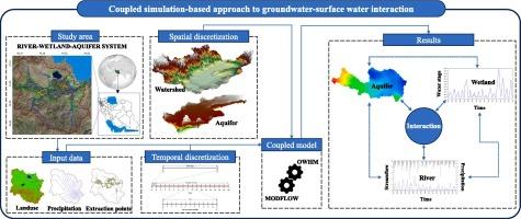
Assessing the interaction between surface water (SW) and groundwater (GW) is crucial to managing water resources effectively and efficiently. It is important to consider all SW-GW factors to assess SW-GW interaction accurately using models. In this study, a coupled model was developed for configuring SW-GW interaction at the regional watershed scale. Through coupled MODFLOW and OWHM (MF-OWHM), simulations were performed to show interaction effects and spatiotemporal variability. The developed methodology was applied to a real case study in Iran’s northwest to quantify the interaction between the Gadar river and Dorgeh wetland with the Naghadeh aquifer. The MF-OWHM adequately simulated the groundwater level (GWL) for the calibration (2001–2011, R2 = 0.84, RMSE = 0.61 m) and validation (2012–2017, R2 = 0.78, RMSE = 0.89 m) periods. The results showed that wetland inflow is mostly from surface water (66.6 %), whereas groundwater is minimal (1.6 %). However, the decline in GWL has led to a reduction in the wetland stage, therefore the wetland stage can serve as an indicator of GWL. The river recharges (43.29 MCM) and drains the aquifer (29.2 MCM) along its path. Examining several hydrological scenarios, it was found that transferring water from the river (0.2 MCM per day) and reducing the groundwater withdrawals (up to 100 %) near the wetland can prevent wetland drying. Conversely, scenarios involving changes in land use upstream of the wetland, dam construction, and increasing withdrawals (up to 100 %) dry the wetland. Changes at the local scale in the SW only affected its local condition while these changes altered the GWL throughout the aquifer (−6.3 to + 3.8 m). Based on these results, SW-GW water resources should be exploited and managed in a way that considers the interactions for sustainable water use.
期刊介绍:
The Journal of Hydrology publishes original research papers and comprehensive reviews in all the subfields of the hydrological sciences including water based management and policy issues that impact on economics and society. These comprise, but are not limited to the physical, chemical, biogeochemical, stochastic and systems aspects of surface and groundwater hydrology, hydrometeorology and hydrogeology. Relevant topics incorporating the insights and methodologies of disciplines such as climatology, water resource systems, hydraulics, agrohydrology, geomorphology, soil science, instrumentation and remote sensing, civil and environmental engineering are included. Social science perspectives on hydrological problems such as resource and ecological economics, environmental sociology, psychology and behavioural science, management and policy analysis are also invited. Multi-and interdisciplinary analyses of hydrological problems are within scope. The science published in the Journal of Hydrology is relevant to catchment scales rather than exclusively to a local scale or site.




 京公网安备 11010802042870号
京ICP备2023020795号-1
京公网安备 11010802042870号
京ICP备2023020795号-1

 分享
分享
 求助内容:
求助内容: 应助结果提醒方式:
 扫码关注我们
