{"title":"使用结构和非结构网格对粗糙地形起伏下的石灰华岩石进行地电模拟","authors":"Mohammad Ali Talebi, Maysam Abedi, Ali Moradzadeh","doi":"10.1007/s40328-022-00381-9","DOIUrl":null,"url":null,"abstract":"<div><p>Geoelectric surveys are among popular subsurface geophysical imaging techniques that provide significant insights into the electrical properties of subsurface targets. In this research, geoelectric modeling of travertine deposits at the Atashkohe region in Iran is performed through discretizing the physical model domain through structured (quadrilateral) and unstructured (triangular) meshes. This meshing tool captures the accurate borders of a rugged topography area along with any complex-shaped travertine sources. The modeling process was accomplished through utilizing an open-source python-based software called “ResIPy”, which handles all processing steps necessary for reliable forward and inversion of geoelectrical data (i.e., electrical resistivity and induced polarization). Three synthetic electrical models according to the geological background of the studied area were simulated to examine the efficiency of the 2D electrical survey in imaging the travertine building stone. Two types of structured and unstructured meshing were designed to cope with the rough topography surface and any intricate geometry of subsurface target. The inversion results of the synthetic models approved the accuracy and efficiency of both geoelectrical survey and data modeling in travertine exploration. Finally, as a case study, tomography data of electrical resistivity and chargeability taken from the Atashkohe travertine mine were geophysically modeled to infer geological sections along three 2D profiles surveyed in the region. Data were collected with an electrode spacing of 15 or 10 m through a combination of dipole-dipole and pole-dipole arrays. The results of inverse modeling indicated that the provided geological and electrical sections at depth could be related to travertine lenses and further survey can help delineation of these building rocks. Comparison of electrical models and stratigraphic column obtained from two drillings along one profile showed a relatively good agreement as well.</p></div>","PeriodicalId":48965,"journal":{"name":"Acta Geodaetica et Geophysica","volume":"57 2","pages":"351 - 372"},"PeriodicalIF":1.8000,"publicationDate":"2022-06-03","publicationTypes":"Journal Article","fieldsOfStudy":null,"isOpenAccess":false,"openAccessPdf":"","citationCount":"0","resultStr":"{\"title\":\"Geoelectrical modeling of travertine rocks beneath a rough topographical relief using structured and unstructured meshes\",\"authors\":\"Mohammad Ali Talebi, Maysam Abedi, Ali Moradzadeh\",\"doi\":\"10.1007/s40328-022-00381-9\",\"DOIUrl\":null,\"url\":null,\"abstract\":\"<div><p>Geoelectric surveys are among popular subsurface geophysical imaging techniques that provide significant insights into the electrical properties of subsurface targets. In this research, geoelectric modeling of travertine deposits at the Atashkohe region in Iran is performed through discretizing the physical model domain through structured (quadrilateral) and unstructured (triangular) meshes. This meshing tool captures the accurate borders of a rugged topography area along with any complex-shaped travertine sources. The modeling process was accomplished through utilizing an open-source python-based software called “ResIPy”, which handles all processing steps necessary for reliable forward and inversion of geoelectrical data (i.e., electrical resistivity and induced polarization). Three synthetic electrical models according to the geological background of the studied area were simulated to examine the efficiency of the 2D electrical survey in imaging the travertine building stone. Two types of structured and unstructured meshing were designed to cope with the rough topography surface and any intricate geometry of subsurface target. The inversion results of the synthetic models approved the accuracy and efficiency of both geoelectrical survey and data modeling in travertine exploration. Finally, as a case study, tomography data of electrical resistivity and chargeability taken from the Atashkohe travertine mine were geophysically modeled to infer geological sections along three 2D profiles surveyed in the region. Data were collected with an electrode spacing of 15 or 10 m through a combination of dipole-dipole and pole-dipole arrays. The results of inverse modeling indicated that the provided geological and electrical sections at depth could be related to travertine lenses and further survey can help delineation of these building rocks. Comparison of electrical models and stratigraphic column obtained from two drillings along one profile showed a relatively good agreement as well.</p></div>\",\"PeriodicalId\":48965,\"journal\":{\"name\":\"Acta Geodaetica et Geophysica\",\"volume\":\"57 2\",\"pages\":\"351 - 372\"},\"PeriodicalIF\":1.8000,\"publicationDate\":\"2022-06-03\",\"publicationTypes\":\"Journal Article\",\"fieldsOfStudy\":null,\"isOpenAccess\":false,\"openAccessPdf\":\"\",\"citationCount\":\"0\",\"resultStr\":null,\"platform\":\"Semanticscholar\",\"paperid\":null,\"PeriodicalName\":\"Acta Geodaetica et Geophysica\",\"FirstCategoryId\":\"89\",\"ListUrlMain\":\"https://link.springer.com/article/10.1007/s40328-022-00381-9\",\"RegionNum\":4,\"RegionCategory\":\"地球科学\",\"ArticlePicture\":[],\"TitleCN\":null,\"AbstractTextCN\":null,\"PMCID\":null,\"EPubDate\":\"\",\"PubModel\":\"\",\"JCR\":\"Q3\",\"JCRName\":\"GEOCHEMISTRY & GEOPHYSICS\",\"Score\":null,\"Total\":0}","platform":"Semanticscholar","paperid":null,"PeriodicalName":"Acta Geodaetica et Geophysica","FirstCategoryId":"89","ListUrlMain":"https://link.springer.com/article/10.1007/s40328-022-00381-9","RegionNum":4,"RegionCategory":"地球科学","ArticlePicture":[],"TitleCN":null,"AbstractTextCN":null,"PMCID":null,"EPubDate":"","PubModel":"","JCR":"Q3","JCRName":"GEOCHEMISTRY & GEOPHYSICS","Score":null,"Total":0}
Geoelectrical modeling of travertine rocks beneath a rough topographical relief using structured and unstructured meshes
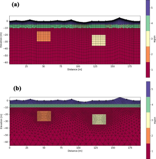
Geoelectric surveys are among popular subsurface geophysical imaging techniques that provide significant insights into the electrical properties of subsurface targets. In this research, geoelectric modeling of travertine deposits at the Atashkohe region in Iran is performed through discretizing the physical model domain through structured (quadrilateral) and unstructured (triangular) meshes. This meshing tool captures the accurate borders of a rugged topography area along with any complex-shaped travertine sources. The modeling process was accomplished through utilizing an open-source python-based software called “ResIPy”, which handles all processing steps necessary for reliable forward and inversion of geoelectrical data (i.e., electrical resistivity and induced polarization). Three synthetic electrical models according to the geological background of the studied area were simulated to examine the efficiency of the 2D electrical survey in imaging the travertine building stone. Two types of structured and unstructured meshing were designed to cope with the rough topography surface and any intricate geometry of subsurface target. The inversion results of the synthetic models approved the accuracy and efficiency of both geoelectrical survey and data modeling in travertine exploration. Finally, as a case study, tomography data of electrical resistivity and chargeability taken from the Atashkohe travertine mine were geophysically modeled to infer geological sections along three 2D profiles surveyed in the region. Data were collected with an electrode spacing of 15 or 10 m through a combination of dipole-dipole and pole-dipole arrays. The results of inverse modeling indicated that the provided geological and electrical sections at depth could be related to travertine lenses and further survey can help delineation of these building rocks. Comparison of electrical models and stratigraphic column obtained from two drillings along one profile showed a relatively good agreement as well.
期刊介绍:
The journal publishes original research papers in the field of geodesy and geophysics under headings: aeronomy and space physics, electromagnetic studies, geodesy and gravimetry, geodynamics, geomathematics, rock physics, seismology, solid earth physics, history. Papers dealing with problems of the Carpathian region and its surroundings are preferred. Similarly, papers on topics traditionally covered by Hungarian geodesists and geophysicists (e.g. robust estimations, geoid, EM properties of the Earth’s crust, geomagnetic pulsations and seismological risk) are especially welcome.


 分享
分享
 求助内容:
求助内容: 应助结果提醒方式:
 扫码关注我们
