{"title":"易受气候变化影响的地理位置:来自印度喜马拉雅山麓的经验证据","authors":"Manoranjan Ghosh, Somnath Ghosal","doi":"10.1007/s41685-022-00273-4","DOIUrl":null,"url":null,"abstract":"<div><p>In India, there is a need for field survey-based vulnerability studies to overcome the uncertainties that exist in regional model-based climate vulnerability assessments. Therefore, the present study explored the regional patterns and their associated determinant factors of climate change vulnerability in the Himalayan Foothills of West Bengal to determine which regions are more vulnerable in the same geographical space. The research was conducted in the 13 Community Development Blocks (CD Blocks) of the Himalayan Foothills of West Bengal, India. The Socio-Economic Vulnerability Index (SEVI) was proposed to fulfill the above objectives. The present SEVI was comprised of seven subdimensions of climate change vulnerability: namely, climate variability, natural disaster risk, socio-demographic profile, livelihood strategy, environment profile, livelihood security, and accessibility of basic infrastructure covering three major vulnerability components, exposure, adaptive capacity, and sensitivity. The primary field survey was conducted using a structured questionnaire for data collection comprised of 22 indicators covering seven significant dimensions. The results suggest that Alipurduar-II, Jalpaiguri, and Mal, which are highly exposed to climate variability and natural disaster risk at the same time, have low adaptive capacities. The livelihood strategy, socio-demographic, and environmental profile were the determining factors of regional vulnerability in the study area. The CD blocks Falakata, Dhupguri, and Rajganj showed a higher adaptive capacity and were less sensitive to climate change vulnerability, even though exposure to climate change was the same in the entire area. The survey findings indicate that adaptive capacity is high in Falakata and Rajganj and these areas are less susceptible to climate change vulnerability. Finally, the appropriate recommendation is to develop a basic physical infrastructure, including bridges over the rivers and concrete village roads in all the flood-prone villages in the entire Himalayan Foothills of West Bengal for better connectivity. Also, household food availability should be secured through public distribution systems that develop the coping capacity of the region as a whole.</p></div>","PeriodicalId":36164,"journal":{"name":"Asia-Pacific Journal of Regional Science","volume":"7 2","pages":"405 - 431"},"PeriodicalIF":1.7000,"publicationDate":"2023-01-25","publicationTypes":"Journal Article","fieldsOfStudy":null,"isOpenAccess":false,"openAccessPdf":"","citationCount":"1","resultStr":"{\"title\":\"Geographies of vulnerability to climate change: empirical evidences from the Indian Himalayan foothills\",\"authors\":\"Manoranjan Ghosh, Somnath Ghosal\",\"doi\":\"10.1007/s41685-022-00273-4\",\"DOIUrl\":null,\"url\":null,\"abstract\":\"<div><p>In India, there is a need for field survey-based vulnerability studies to overcome the uncertainties that exist in regional model-based climate vulnerability assessments. Therefore, the present study explored the regional patterns and their associated determinant factors of climate change vulnerability in the Himalayan Foothills of West Bengal to determine which regions are more vulnerable in the same geographical space. The research was conducted in the 13 Community Development Blocks (CD Blocks) of the Himalayan Foothills of West Bengal, India. The Socio-Economic Vulnerability Index (SEVI) was proposed to fulfill the above objectives. The present SEVI was comprised of seven subdimensions of climate change vulnerability: namely, climate variability, natural disaster risk, socio-demographic profile, livelihood strategy, environment profile, livelihood security, and accessibility of basic infrastructure covering three major vulnerability components, exposure, adaptive capacity, and sensitivity. The primary field survey was conducted using a structured questionnaire for data collection comprised of 22 indicators covering seven significant dimensions. The results suggest that Alipurduar-II, Jalpaiguri, and Mal, which are highly exposed to climate variability and natural disaster risk at the same time, have low adaptive capacities. The livelihood strategy, socio-demographic, and environmental profile were the determining factors of regional vulnerability in the study area. The CD blocks Falakata, Dhupguri, and Rajganj showed a higher adaptive capacity and were less sensitive to climate change vulnerability, even though exposure to climate change was the same in the entire area. The survey findings indicate that adaptive capacity is high in Falakata and Rajganj and these areas are less susceptible to climate change vulnerability. Finally, the appropriate recommendation is to develop a basic physical infrastructure, including bridges over the rivers and concrete village roads in all the flood-prone villages in the entire Himalayan Foothills of West Bengal for better connectivity. Also, household food availability should be secured through public distribution systems that develop the coping capacity of the region as a whole.</p></div>\",\"PeriodicalId\":36164,\"journal\":{\"name\":\"Asia-Pacific Journal of Regional Science\",\"volume\":\"7 2\",\"pages\":\"405 - 431\"},\"PeriodicalIF\":1.7000,\"publicationDate\":\"2023-01-25\",\"publicationTypes\":\"Journal Article\",\"fieldsOfStudy\":null,\"isOpenAccess\":false,\"openAccessPdf\":\"\",\"citationCount\":\"1\",\"resultStr\":null,\"platform\":\"Semanticscholar\",\"paperid\":null,\"PeriodicalName\":\"Asia-Pacific Journal of Regional Science\",\"FirstCategoryId\":\"1085\",\"ListUrlMain\":\"https://link.springer.com/article/10.1007/s41685-022-00273-4\",\"RegionNum\":0,\"RegionCategory\":null,\"ArticlePicture\":[],\"TitleCN\":null,\"AbstractTextCN\":null,\"PMCID\":null,\"EPubDate\":\"\",\"PubModel\":\"\",\"JCR\":\"Q2\",\"JCRName\":\"ECONOMICS\",\"Score\":null,\"Total\":0}","platform":"Semanticscholar","paperid":null,"PeriodicalName":"Asia-Pacific Journal of Regional Science","FirstCategoryId":"1085","ListUrlMain":"https://link.springer.com/article/10.1007/s41685-022-00273-4","RegionNum":0,"RegionCategory":null,"ArticlePicture":[],"TitleCN":null,"AbstractTextCN":null,"PMCID":null,"EPubDate":"","PubModel":"","JCR":"Q2","JCRName":"ECONOMICS","Score":null,"Total":0}
Geographies of vulnerability to climate change: empirical evidences from the Indian Himalayan foothills
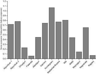
In India, there is a need for field survey-based vulnerability studies to overcome the uncertainties that exist in regional model-based climate vulnerability assessments. Therefore, the present study explored the regional patterns and their associated determinant factors of climate change vulnerability in the Himalayan Foothills of West Bengal to determine which regions are more vulnerable in the same geographical space. The research was conducted in the 13 Community Development Blocks (CD Blocks) of the Himalayan Foothills of West Bengal, India. The Socio-Economic Vulnerability Index (SEVI) was proposed to fulfill the above objectives. The present SEVI was comprised of seven subdimensions of climate change vulnerability: namely, climate variability, natural disaster risk, socio-demographic profile, livelihood strategy, environment profile, livelihood security, and accessibility of basic infrastructure covering three major vulnerability components, exposure, adaptive capacity, and sensitivity. The primary field survey was conducted using a structured questionnaire for data collection comprised of 22 indicators covering seven significant dimensions. The results suggest that Alipurduar-II, Jalpaiguri, and Mal, which are highly exposed to climate variability and natural disaster risk at the same time, have low adaptive capacities. The livelihood strategy, socio-demographic, and environmental profile were the determining factors of regional vulnerability in the study area. The CD blocks Falakata, Dhupguri, and Rajganj showed a higher adaptive capacity and were less sensitive to climate change vulnerability, even though exposure to climate change was the same in the entire area. The survey findings indicate that adaptive capacity is high in Falakata and Rajganj and these areas are less susceptible to climate change vulnerability. Finally, the appropriate recommendation is to develop a basic physical infrastructure, including bridges over the rivers and concrete village roads in all the flood-prone villages in the entire Himalayan Foothills of West Bengal for better connectivity. Also, household food availability should be secured through public distribution systems that develop the coping capacity of the region as a whole.
期刊介绍:
The Asia-Pacific Journal of Regional Science expands the frontiers of regional science through the diffusion of intrinsically developed and advanced modern, regional science methodologies throughout the Asia-Pacific region. Articles published in the journal foster progress and development of regional science through the promotion of comprehensive and interdisciplinary academic studies in relationship to research in regional science across the globe. The journal’s scope includes articles dedicated to theoretical economics, positive economics including econometrics and statistical analysis and input–output analysis, CGE, Simulation, applied economics including international economics, regional economics, industrial organization, analysis of governance and institutional issues, law and economics, migration and labor markets, spatial economics, land economics, urban economics, agricultural economics, environmental economics, behavioral economics and spatial analysis with GIS/RS data education economics, sociology including urban sociology, rural sociology, environmental sociology and educational sociology, as well as traffic engineering. The journal provides a unique platform for its research community to further develop, analyze, and resolve urgent regional and urban issues in Asia, and to further refine established research around the world in this multidisciplinary field. The journal invites original articles, proposals, and book reviews.The Asia-Pacific Journal of Regional Science is a new English-language journal that spun out of Chiikigakukenkyuu, which has a 45-year history of publishing the best Japanese research in regional science in the Japanese language and, more recently and more frequently, in English. The development of regional science as an international discipline has necessitated the need for a new publication in English. The Asia-Pacific Journal of Regional Science is a publishing vehicle for English-language contributions to the field in Japan, across the complete Asia-Pacific arena, and beyond.Content published in this journal is peer reviewed (Double Blind).


 分享
分享
 求助内容:
求助内容: 应助结果提醒方式:
 扫码关注我们
