Devin Harrison, Neil Ross, Andrew J. Russell, Stuart J. Jones
{"title":"冰岛东南部Skeiðarársandur大型埋藏冰-边缘陆地系统探地雷达调查","authors":"Devin Harrison, Neil Ross, Andrew J. Russell, Stuart J. Jones","doi":"10.1111/bor.12587","DOIUrl":null,"url":null,"abstract":"<p>The sedimentary record of Icelandic ice-contact environments provides critical insights into past glacier margin dynamics and position, relative sea level, and the geomorphic processes that drive the evolution of proglacial environments. This important archive has been little exploited, however, with most glacier and sea-level reconstructions based on limited sedimentary exposures, coring and surface geomorphic evidence. We report an extensive (42 km of data within a 24-km<sup>2</sup> study area) and deep (reflections recorded at depths up to 100 m) low-frequency (40 and 100 MHz) ground-penetrating radar (GPR) survey of the Sandgígur moraines, SE Iceland. GPR profiles reveal a much larger (67 m high) and extensive (1.25 km wide) buried moraine ridge than that suggested by surface topography (typically 125 m wide and 7 m high). These data reveal that the Sandgígur moraines was deposited during a major Holocene re-advance of Skeiðarárjökull. The moraine ridge is buried by sediments dominated by glacifluvial deposits with an estimated sediment volume of 1.04 km<sup>3</sup>. We combine GPR-derived subsurface architecture and the surface morphology to develop a conceptual model detailing the geomorphic evolution of the moraine and surrounding region. These results provide new insights into the Holocene evolution of Skeiðarársandur, identifying the presence of a former major ice-margin position, as well as a past relative sea-level limit. Furthermore, we establish that sediment supply and available terrestrial accommodation space are dominant drivers in the formation and evolution of vast sandar environments.</p>","PeriodicalId":9184,"journal":{"name":"Boreas","volume":"51 4","pages":"824-846"},"PeriodicalIF":2.4000,"publicationDate":"2022-03-20","publicationTypes":"Journal Article","fieldsOfStudy":null,"isOpenAccess":false,"openAccessPdf":"https://onlinelibrary.wiley.com/doi/epdf/10.1111/bor.12587","citationCount":"3","resultStr":"{\"title\":\"Ground-penetrating radar (GPR) investigations of a large-scale buried ice-marginal landsystem, Skeiðarársandur, SE Iceland\",\"authors\":\"Devin Harrison, Neil Ross, Andrew J. Russell, Stuart J. Jones\",\"doi\":\"10.1111/bor.12587\",\"DOIUrl\":null,\"url\":null,\"abstract\":\"<p>The sedimentary record of Icelandic ice-contact environments provides critical insights into past glacier margin dynamics and position, relative sea level, and the geomorphic processes that drive the evolution of proglacial environments. This important archive has been little exploited, however, with most glacier and sea-level reconstructions based on limited sedimentary exposures, coring and surface geomorphic evidence. We report an extensive (42 km of data within a 24-km<sup>2</sup> study area) and deep (reflections recorded at depths up to 100 m) low-frequency (40 and 100 MHz) ground-penetrating radar (GPR) survey of the Sandgígur moraines, SE Iceland. GPR profiles reveal a much larger (67 m high) and extensive (1.25 km wide) buried moraine ridge than that suggested by surface topography (typically 125 m wide and 7 m high). These data reveal that the Sandgígur moraines was deposited during a major Holocene re-advance of Skeiðarárjökull. The moraine ridge is buried by sediments dominated by glacifluvial deposits with an estimated sediment volume of 1.04 km<sup>3</sup>. We combine GPR-derived subsurface architecture and the surface morphology to develop a conceptual model detailing the geomorphic evolution of the moraine and surrounding region. These results provide new insights into the Holocene evolution of Skeiðarársandur, identifying the presence of a former major ice-margin position, as well as a past relative sea-level limit. Furthermore, we establish that sediment supply and available terrestrial accommodation space are dominant drivers in the formation and evolution of vast sandar environments.</p>\",\"PeriodicalId\":9184,\"journal\":{\"name\":\"Boreas\",\"volume\":\"51 4\",\"pages\":\"824-846\"},\"PeriodicalIF\":2.4000,\"publicationDate\":\"2022-03-20\",\"publicationTypes\":\"Journal Article\",\"fieldsOfStudy\":null,\"isOpenAccess\":false,\"openAccessPdf\":\"https://onlinelibrary.wiley.com/doi/epdf/10.1111/bor.12587\",\"citationCount\":\"3\",\"resultStr\":null,\"platform\":\"Semanticscholar\",\"paperid\":null,\"PeriodicalName\":\"Boreas\",\"FirstCategoryId\":\"89\",\"ListUrlMain\":\"https://onlinelibrary.wiley.com/doi/10.1111/bor.12587\",\"RegionNum\":3,\"RegionCategory\":\"地球科学\",\"ArticlePicture\":[],\"TitleCN\":null,\"AbstractTextCN\":null,\"PMCID\":null,\"EPubDate\":\"\",\"PubModel\":\"\",\"JCR\":\"Q2\",\"JCRName\":\"GEOGRAPHY, PHYSICAL\",\"Score\":null,\"Total\":0}","platform":"Semanticscholar","paperid":null,"PeriodicalName":"Boreas","FirstCategoryId":"89","ListUrlMain":"https://onlinelibrary.wiley.com/doi/10.1111/bor.12587","RegionNum":3,"RegionCategory":"地球科学","ArticlePicture":[],"TitleCN":null,"AbstractTextCN":null,"PMCID":null,"EPubDate":"","PubModel":"","JCR":"Q2","JCRName":"GEOGRAPHY, PHYSICAL","Score":null,"Total":0}
Ground-penetrating radar (GPR) investigations of a large-scale buried ice-marginal landsystem, Skeiðarársandur, SE Iceland
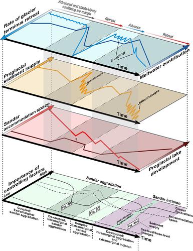
The sedimentary record of Icelandic ice-contact environments provides critical insights into past glacier margin dynamics and position, relative sea level, and the geomorphic processes that drive the evolution of proglacial environments. This important archive has been little exploited, however, with most glacier and sea-level reconstructions based on limited sedimentary exposures, coring and surface geomorphic evidence. We report an extensive (42 km of data within a 24-km2 study area) and deep (reflections recorded at depths up to 100 m) low-frequency (40 and 100 MHz) ground-penetrating radar (GPR) survey of the Sandgígur moraines, SE Iceland. GPR profiles reveal a much larger (67 m high) and extensive (1.25 km wide) buried moraine ridge than that suggested by surface topography (typically 125 m wide and 7 m high). These data reveal that the Sandgígur moraines was deposited during a major Holocene re-advance of Skeiðarárjökull. The moraine ridge is buried by sediments dominated by glacifluvial deposits with an estimated sediment volume of 1.04 km3. We combine GPR-derived subsurface architecture and the surface morphology to develop a conceptual model detailing the geomorphic evolution of the moraine and surrounding region. These results provide new insights into the Holocene evolution of Skeiðarársandur, identifying the presence of a former major ice-margin position, as well as a past relative sea-level limit. Furthermore, we establish that sediment supply and available terrestrial accommodation space are dominant drivers in the formation and evolution of vast sandar environments.
期刊介绍:
Boreas has been published since 1972. Articles of wide international interest from all branches of Quaternary research are published. Biological as well as non-biological aspects of the Quaternary environment, in both glaciated and non-glaciated areas, are dealt with: Climate, shore displacement, glacial features, landforms, sediments, organisms and their habitat, and stratigraphical and chronological relationships.
Anticipated international interest, at least within a continent or a considerable part of it, is a main criterion for the acceptance of papers. Besides articles, short items like discussion contributions and book reviews are published.


 分享
分享
 求助内容:
求助内容: 应助结果提醒方式:
 扫码关注我们
