Siniša Delčev, Jelena Gučević, Nikolina Mijić, Olivera Vasović
{"title":"不同高程系统下修正精度计算的实例研究","authors":"Siniša Delčev, Jelena Gučević, Nikolina Mijić, Olivera Vasović","doi":"10.1007/s40328-022-00380-w","DOIUrl":null,"url":null,"abstract":"<div><p>Works on establishment of the spirit levelling network in the Balkan countries were ruled by the political and economic circumstances. This was subject to the analysis since the Austro-Hungarian Monarchy period, over former Yugoslavia in all of its political forms, down to the present countries of the Balkan Peninsula. Heights differences and heights are part of the II Levelling Network of High Accuracy (II.NVT network). The works on establishment of II.NVT network have been organized and performed by the Federal Geodetic Administration of former Yugoslavia and the Geodetic Administrations of the accompanying Republics. The Military-Geographic Institute from Belgrade had performed gravity measurements over one part of the levelling network. “The II.NVT network data are the subject of computer processing, modern analyses, fundamental and applied scientific researches and application in solving some practical tasks” (Rožić in Acta Geodaetica et Geophysica Hungarica 36(2):231–243, 2001). Calculations of accuracy of corrections in different height systems will be presented in this paper. The subject of this analysis is the error sources in the corrections for the orthometric, normal, and normal orthometric heights. The error sources that accompany the spirit levelling procedure are, for the most part, examined with the assumption that the height difference may be determined with the accuracy of 1.0 mm/km. The corrections in different height systems will be made through the function of a link to the directly/indirectly measured values. The accuracy of the correction will be presented by applying the law of error propagation on the data collected in the II.NVT network for the territory with the characteristic relief. The reason for writing this paper is noted deviation from theoretical assumptions on the shape of reference surfaces in the various height systems. The deviation noted are in the part of relief characteristic over the deep karst and high mountains in one polygon of the II.NVT network, over the distance of 40 km.</p></div>","PeriodicalId":48965,"journal":{"name":"Acta Geodaetica et Geophysica","volume":"57 2","pages":"335 - 350"},"PeriodicalIF":1.8000,"publicationDate":"2022-06-20","publicationTypes":"Journal Article","fieldsOfStudy":null,"isOpenAccess":false,"openAccessPdf":"https://link.springer.com/content/pdf/10.1007/s40328-022-00380-w.pdf","citationCount":"0","resultStr":"{\"title\":\"Case study of the accuracy calculations of corrections in different height systems\",\"authors\":\"Siniša Delčev, Jelena Gučević, Nikolina Mijić, Olivera Vasović\",\"doi\":\"10.1007/s40328-022-00380-w\",\"DOIUrl\":null,\"url\":null,\"abstract\":\"<div><p>Works on establishment of the spirit levelling network in the Balkan countries were ruled by the political and economic circumstances. This was subject to the analysis since the Austro-Hungarian Monarchy period, over former Yugoslavia in all of its political forms, down to the present countries of the Balkan Peninsula. Heights differences and heights are part of the II Levelling Network of High Accuracy (II.NVT network). The works on establishment of II.NVT network have been organized and performed by the Federal Geodetic Administration of former Yugoslavia and the Geodetic Administrations of the accompanying Republics. The Military-Geographic Institute from Belgrade had performed gravity measurements over one part of the levelling network. “The II.NVT network data are the subject of computer processing, modern analyses, fundamental and applied scientific researches and application in solving some practical tasks” (Rožić in Acta Geodaetica et Geophysica Hungarica 36(2):231–243, 2001). Calculations of accuracy of corrections in different height systems will be presented in this paper. The subject of this analysis is the error sources in the corrections for the orthometric, normal, and normal orthometric heights. The error sources that accompany the spirit levelling procedure are, for the most part, examined with the assumption that the height difference may be determined with the accuracy of 1.0 mm/km. The corrections in different height systems will be made through the function of a link to the directly/indirectly measured values. The accuracy of the correction will be presented by applying the law of error propagation on the data collected in the II.NVT network for the territory with the characteristic relief. The reason for writing this paper is noted deviation from theoretical assumptions on the shape of reference surfaces in the various height systems. The deviation noted are in the part of relief characteristic over the deep karst and high mountains in one polygon of the II.NVT network, over the distance of 40 km.</p></div>\",\"PeriodicalId\":48965,\"journal\":{\"name\":\"Acta Geodaetica et Geophysica\",\"volume\":\"57 2\",\"pages\":\"335 - 350\"},\"PeriodicalIF\":1.8000,\"publicationDate\":\"2022-06-20\",\"publicationTypes\":\"Journal Article\",\"fieldsOfStudy\":null,\"isOpenAccess\":false,\"openAccessPdf\":\"https://link.springer.com/content/pdf/10.1007/s40328-022-00380-w.pdf\",\"citationCount\":\"0\",\"resultStr\":null,\"platform\":\"Semanticscholar\",\"paperid\":null,\"PeriodicalName\":\"Acta Geodaetica et Geophysica\",\"FirstCategoryId\":\"89\",\"ListUrlMain\":\"https://link.springer.com/article/10.1007/s40328-022-00380-w\",\"RegionNum\":4,\"RegionCategory\":\"地球科学\",\"ArticlePicture\":[],\"TitleCN\":null,\"AbstractTextCN\":null,\"PMCID\":null,\"EPubDate\":\"\",\"PubModel\":\"\",\"JCR\":\"Q3\",\"JCRName\":\"GEOCHEMISTRY & GEOPHYSICS\",\"Score\":null,\"Total\":0}","platform":"Semanticscholar","paperid":null,"PeriodicalName":"Acta Geodaetica et Geophysica","FirstCategoryId":"89","ListUrlMain":"https://link.springer.com/article/10.1007/s40328-022-00380-w","RegionNum":4,"RegionCategory":"地球科学","ArticlePicture":[],"TitleCN":null,"AbstractTextCN":null,"PMCID":null,"EPubDate":"","PubModel":"","JCR":"Q3","JCRName":"GEOCHEMISTRY & GEOPHYSICS","Score":null,"Total":0}
Case study of the accuracy calculations of corrections in different height systems
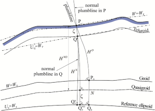
Works on establishment of the spirit levelling network in the Balkan countries were ruled by the political and economic circumstances. This was subject to the analysis since the Austro-Hungarian Monarchy period, over former Yugoslavia in all of its political forms, down to the present countries of the Balkan Peninsula. Heights differences and heights are part of the II Levelling Network of High Accuracy (II.NVT network). The works on establishment of II.NVT network have been organized and performed by the Federal Geodetic Administration of former Yugoslavia and the Geodetic Administrations of the accompanying Republics. The Military-Geographic Institute from Belgrade had performed gravity measurements over one part of the levelling network. “The II.NVT network data are the subject of computer processing, modern analyses, fundamental and applied scientific researches and application in solving some practical tasks” (Rožić in Acta Geodaetica et Geophysica Hungarica 36(2):231–243, 2001). Calculations of accuracy of corrections in different height systems will be presented in this paper. The subject of this analysis is the error sources in the corrections for the orthometric, normal, and normal orthometric heights. The error sources that accompany the spirit levelling procedure are, for the most part, examined with the assumption that the height difference may be determined with the accuracy of 1.0 mm/km. The corrections in different height systems will be made through the function of a link to the directly/indirectly measured values. The accuracy of the correction will be presented by applying the law of error propagation on the data collected in the II.NVT network for the territory with the characteristic relief. The reason for writing this paper is noted deviation from theoretical assumptions on the shape of reference surfaces in the various height systems. The deviation noted are in the part of relief characteristic over the deep karst and high mountains in one polygon of the II.NVT network, over the distance of 40 km.
期刊介绍:
The journal publishes original research papers in the field of geodesy and geophysics under headings: aeronomy and space physics, electromagnetic studies, geodesy and gravimetry, geodynamics, geomathematics, rock physics, seismology, solid earth physics, history. Papers dealing with problems of the Carpathian region and its surroundings are preferred. Similarly, papers on topics traditionally covered by Hungarian geodesists and geophysicists (e.g. robust estimations, geoid, EM properties of the Earth’s crust, geomagnetic pulsations and seismological risk) are especially welcome.


 分享
分享
 求助内容:
求助内容: 应助结果提醒方式:
 扫码关注我们
