{"title":"基米米(布滕博/刚果民主共和国)城市流域沟槽侵蚀演变及易感因素","authors":"Jonathan Ahadi Mahamba , Gloire Mulondi Kayitoghera , Moïse Kapiri Musubao , Géant Basimine Chuma , Walere Muhindo Sahani","doi":"10.1016/j.geosus.2023.07.001","DOIUrl":null,"url":null,"abstract":"<div><p>Gully erosion is one of the most intense landscape degradation mechanisms in areas with varying environmental characteristics. Both natural and anthropogenic factors affect the gullying process. Reliable documentation of these processes in tropical African cities is scarce. This study assessed the gully erosion dynamic and the susceptibility factors in the urban watershed of Kimemi in eastern Democratic Republic of Congo (DRC). Data were obtained through a combination of fieldwork and digitization of very high spatial resolution images from Google Earth (from 2011 to 2021). The length, width, and area of large gullies (width ≥ 5 m) were measured for each year of the study. A logistic regression model (LRM) was also used to investigate the influence of both physical and anthropogenic factors on gully susceptibility. The results revealed that the number of gullies has increased from 36 to 61 during the last decade. The gully mean length of 63.9 ± 61.1 m, 129.3 ± 104.9 m, and 174.7 ± 153.8 m were obtained for the years 2011, 2015, and 2021 respectively. The average density of gully network for the study period was 0.12 km/km², while the degraded land was ∼1.3 and ∼1.1 ha/year for 2011–2015 and 2015–2021 for the entire watershed. The significant changes in morphometric parameters (length, width, area) were found only in the bare land and building land uses. A strong and positive relationship between the length (m) and the area (ha) was found. Furthermore, the susceptibility of gullying was significantly influenced by the slope, stream power index (SPI), distance to roads and rivers, land use and land cover (LULC), and normalized difference vegetation index (NDVI). This means the areas located in the bare land and building or close to roads and/or streams are more likely to be gullied. The findings emphasize the impact of urbanization on gully erosion in the Kimemi watershed, highlighting the importance of informed land management decisions with a close attention to anthropogenic factors.</p></div>","PeriodicalId":52374,"journal":{"name":"Geography and Sustainability","volume":"4 3","pages":"Pages 268-279"},"PeriodicalIF":8.0000,"publicationDate":"2023-09-01","publicationTypes":"Journal Article","fieldsOfStudy":null,"isOpenAccess":false,"openAccessPdf":"","citationCount":"0","resultStr":"{\"title\":\"Evolution of gully erosion and susceptibility factors in the urban watershed of the Kimemi (Butembo/DR Congo)\",\"authors\":\"Jonathan Ahadi Mahamba , Gloire Mulondi Kayitoghera , Moïse Kapiri Musubao , Géant Basimine Chuma , Walere Muhindo Sahani\",\"doi\":\"10.1016/j.geosus.2023.07.001\",\"DOIUrl\":null,\"url\":null,\"abstract\":\"<div><p>Gully erosion is one of the most intense landscape degradation mechanisms in areas with varying environmental characteristics. Both natural and anthropogenic factors affect the gullying process. Reliable documentation of these processes in tropical African cities is scarce. This study assessed the gully erosion dynamic and the susceptibility factors in the urban watershed of Kimemi in eastern Democratic Republic of Congo (DRC). Data were obtained through a combination of fieldwork and digitization of very high spatial resolution images from Google Earth (from 2011 to 2021). The length, width, and area of large gullies (width ≥ 5 m) were measured for each year of the study. A logistic regression model (LRM) was also used to investigate the influence of both physical and anthropogenic factors on gully susceptibility. The results revealed that the number of gullies has increased from 36 to 61 during the last decade. The gully mean length of 63.9 ± 61.1 m, 129.3 ± 104.9 m, and 174.7 ± 153.8 m were obtained for the years 2011, 2015, and 2021 respectively. The average density of gully network for the study period was 0.12 km/km², while the degraded land was ∼1.3 and ∼1.1 ha/year for 2011–2015 and 2015–2021 for the entire watershed. The significant changes in morphometric parameters (length, width, area) were found only in the bare land and building land uses. A strong and positive relationship between the length (m) and the area (ha) was found. Furthermore, the susceptibility of gullying was significantly influenced by the slope, stream power index (SPI), distance to roads and rivers, land use and land cover (LULC), and normalized difference vegetation index (NDVI). This means the areas located in the bare land and building or close to roads and/or streams are more likely to be gullied. The findings emphasize the impact of urbanization on gully erosion in the Kimemi watershed, highlighting the importance of informed land management decisions with a close attention to anthropogenic factors.</p></div>\",\"PeriodicalId\":52374,\"journal\":{\"name\":\"Geography and Sustainability\",\"volume\":\"4 3\",\"pages\":\"Pages 268-279\"},\"PeriodicalIF\":8.0000,\"publicationDate\":\"2023-09-01\",\"publicationTypes\":\"Journal Article\",\"fieldsOfStudy\":null,\"isOpenAccess\":false,\"openAccessPdf\":\"\",\"citationCount\":\"0\",\"resultStr\":null,\"platform\":\"Semanticscholar\",\"paperid\":null,\"PeriodicalName\":\"Geography and Sustainability\",\"FirstCategoryId\":\"93\",\"ListUrlMain\":\"https://www.sciencedirect.com/science/article/pii/S2666683923000366\",\"RegionNum\":1,\"RegionCategory\":\"环境科学与生态学\",\"ArticlePicture\":[],\"TitleCN\":null,\"AbstractTextCN\":null,\"PMCID\":null,\"EPubDate\":\"2023/7/6 0:00:00\",\"PubModel\":\"Epub\",\"JCR\":\"Q1\",\"JCRName\":\"GEOGRAPHY, PHYSICAL\",\"Score\":null,\"Total\":0}","platform":"Semanticscholar","paperid":null,"PeriodicalName":"Geography and Sustainability","FirstCategoryId":"93","ListUrlMain":"https://www.sciencedirect.com/science/article/pii/S2666683923000366","RegionNum":1,"RegionCategory":"环境科学与生态学","ArticlePicture":[],"TitleCN":null,"AbstractTextCN":null,"PMCID":null,"EPubDate":"2023/7/6 0:00:00","PubModel":"Epub","JCR":"Q1","JCRName":"GEOGRAPHY, PHYSICAL","Score":null,"Total":0}
Evolution of gully erosion and susceptibility factors in the urban watershed of the Kimemi (Butembo/DR Congo)
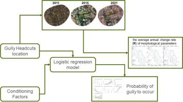
Gully erosion is one of the most intense landscape degradation mechanisms in areas with varying environmental characteristics. Both natural and anthropogenic factors affect the gullying process. Reliable documentation of these processes in tropical African cities is scarce. This study assessed the gully erosion dynamic and the susceptibility factors in the urban watershed of Kimemi in eastern Democratic Republic of Congo (DRC). Data were obtained through a combination of fieldwork and digitization of very high spatial resolution images from Google Earth (from 2011 to 2021). The length, width, and area of large gullies (width ≥ 5 m) were measured for each year of the study. A logistic regression model (LRM) was also used to investigate the influence of both physical and anthropogenic factors on gully susceptibility. The results revealed that the number of gullies has increased from 36 to 61 during the last decade. The gully mean length of 63.9 ± 61.1 m, 129.3 ± 104.9 m, and 174.7 ± 153.8 m were obtained for the years 2011, 2015, and 2021 respectively. The average density of gully network for the study period was 0.12 km/km², while the degraded land was ∼1.3 and ∼1.1 ha/year for 2011–2015 and 2015–2021 for the entire watershed. The significant changes in morphometric parameters (length, width, area) were found only in the bare land and building land uses. A strong and positive relationship between the length (m) and the area (ha) was found. Furthermore, the susceptibility of gullying was significantly influenced by the slope, stream power index (SPI), distance to roads and rivers, land use and land cover (LULC), and normalized difference vegetation index (NDVI). This means the areas located in the bare land and building or close to roads and/or streams are more likely to be gullied. The findings emphasize the impact of urbanization on gully erosion in the Kimemi watershed, highlighting the importance of informed land management decisions with a close attention to anthropogenic factors.
期刊介绍:
Geography and Sustainability serves as a central hub for interdisciplinary research and education aimed at promoting sustainable development from an integrated geography perspective. By bridging natural and human sciences, the journal fosters broader analysis and innovative thinking on global and regional sustainability issues.
Geography and Sustainability welcomes original, high-quality research articles, review articles, short communications, technical comments, perspective articles and editorials on the following themes:
Geographical Processes: Interactions with and between water, soil, atmosphere and the biosphere and their spatio-temporal variations;
Human-Environmental Systems: Interactions between humans and the environment, resilience of socio-ecological systems and vulnerability;
Ecosystem Services and Human Wellbeing: Ecosystem structure, processes, services and their linkages with human wellbeing;
Sustainable Development: Theory, practice and critical challenges in sustainable development.


 分享
分享
 求助内容:
求助内容: 应助结果提醒方式:
 扫码关注我们
