{"title":"基于加权遗传算法和深度学习模型的高光谱图像目标分类","authors":"Davood Akbari, Vahid Akbari","doi":"10.1007/s12518-023-00500-3","DOIUrl":null,"url":null,"abstract":"<div><p>Numerous uses of the hyperspectral remote sensing technology exist for identifying land cover and tracking its evolution. The classification of hyperspectral images must now take into account both spectral and spatial information due to recent advancements and the production of images with high spatial resolution. Convolutional neural networks (CNNs) have much employed in recent years to enhance the classification precision of hyperspectral images. The simultaneous use of spatial feature extraction methods in CNNs has not received significant attention in prior studies. In this study, a novel CNN architecture has been developed for classifying hyperspectral images. The weighted genetic (WG) algorithm is used in the proposed technique to minimize the hyperspectral image’s dimensions. The WG algorithm keeps every band in the image and gives each one weight between zero and one based on how much information it contains. Following the expectation maximization (EM) method to the collected features, the segmented objects are then categorized using the CNN algorithm. Three benchmark hyperspectral images, Pavia, DC Mall, and Indiana Pine, were used to assess the proposed approach. The trials’ findings demonstrate the proposed approach’s superiority over the multilayer perceptron (MLP) algorithm in the Pavia, DC Mall, and Indiana Pine images by 14, 16, and 8% in the overall accuracy parameter, respectively.</p></div>","PeriodicalId":46286,"journal":{"name":"Applied Geomatics","volume":"15 1","pages":"227 - 238"},"PeriodicalIF":2.3000,"publicationDate":"2023-02-27","publicationTypes":"Journal Article","fieldsOfStudy":null,"isOpenAccess":false,"openAccessPdf":"https://link.springer.com/content/pdf/10.1007/s12518-023-00500-3.pdf","citationCount":"0","resultStr":"{\"title\":\"Object-based classification of hyperspectral images based on weighted genetic algorithm and deep learning model\",\"authors\":\"Davood Akbari, Vahid Akbari\",\"doi\":\"10.1007/s12518-023-00500-3\",\"DOIUrl\":null,\"url\":null,\"abstract\":\"<div><p>Numerous uses of the hyperspectral remote sensing technology exist for identifying land cover and tracking its evolution. The classification of hyperspectral images must now take into account both spectral and spatial information due to recent advancements and the production of images with high spatial resolution. Convolutional neural networks (CNNs) have much employed in recent years to enhance the classification precision of hyperspectral images. The simultaneous use of spatial feature extraction methods in CNNs has not received significant attention in prior studies. In this study, a novel CNN architecture has been developed for classifying hyperspectral images. The weighted genetic (WG) algorithm is used in the proposed technique to minimize the hyperspectral image’s dimensions. The WG algorithm keeps every band in the image and gives each one weight between zero and one based on how much information it contains. Following the expectation maximization (EM) method to the collected features, the segmented objects are then categorized using the CNN algorithm. Three benchmark hyperspectral images, Pavia, DC Mall, and Indiana Pine, were used to assess the proposed approach. The trials’ findings demonstrate the proposed approach’s superiority over the multilayer perceptron (MLP) algorithm in the Pavia, DC Mall, and Indiana Pine images by 14, 16, and 8% in the overall accuracy parameter, respectively.</p></div>\",\"PeriodicalId\":46286,\"journal\":{\"name\":\"Applied Geomatics\",\"volume\":\"15 1\",\"pages\":\"227 - 238\"},\"PeriodicalIF\":2.3000,\"publicationDate\":\"2023-02-27\",\"publicationTypes\":\"Journal Article\",\"fieldsOfStudy\":null,\"isOpenAccess\":false,\"openAccessPdf\":\"https://link.springer.com/content/pdf/10.1007/s12518-023-00500-3.pdf\",\"citationCount\":\"0\",\"resultStr\":null,\"platform\":\"Semanticscholar\",\"paperid\":null,\"PeriodicalName\":\"Applied Geomatics\",\"FirstCategoryId\":\"1085\",\"ListUrlMain\":\"https://link.springer.com/article/10.1007/s12518-023-00500-3\",\"RegionNum\":0,\"RegionCategory\":null,\"ArticlePicture\":[],\"TitleCN\":null,\"AbstractTextCN\":null,\"PMCID\":null,\"EPubDate\":\"\",\"PubModel\":\"\",\"JCR\":\"Q2\",\"JCRName\":\"REMOTE SENSING\",\"Score\":null,\"Total\":0}","platform":"Semanticscholar","paperid":null,"PeriodicalName":"Applied Geomatics","FirstCategoryId":"1085","ListUrlMain":"https://link.springer.com/article/10.1007/s12518-023-00500-3","RegionNum":0,"RegionCategory":null,"ArticlePicture":[],"TitleCN":null,"AbstractTextCN":null,"PMCID":null,"EPubDate":"","PubModel":"","JCR":"Q2","JCRName":"REMOTE SENSING","Score":null,"Total":0}
Object-based classification of hyperspectral images based on weighted genetic algorithm and deep learning model
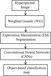
Numerous uses of the hyperspectral remote sensing technology exist for identifying land cover and tracking its evolution. The classification of hyperspectral images must now take into account both spectral and spatial information due to recent advancements and the production of images with high spatial resolution. Convolutional neural networks (CNNs) have much employed in recent years to enhance the classification precision of hyperspectral images. The simultaneous use of spatial feature extraction methods in CNNs has not received significant attention in prior studies. In this study, a novel CNN architecture has been developed for classifying hyperspectral images. The weighted genetic (WG) algorithm is used in the proposed technique to minimize the hyperspectral image’s dimensions. The WG algorithm keeps every band in the image and gives each one weight between zero and one based on how much information it contains. Following the expectation maximization (EM) method to the collected features, the segmented objects are then categorized using the CNN algorithm. Three benchmark hyperspectral images, Pavia, DC Mall, and Indiana Pine, were used to assess the proposed approach. The trials’ findings demonstrate the proposed approach’s superiority over the multilayer perceptron (MLP) algorithm in the Pavia, DC Mall, and Indiana Pine images by 14, 16, and 8% in the overall accuracy parameter, respectively.
期刊介绍:
Applied Geomatics (AGMJ) is the official journal of SIFET the Italian Society of Photogrammetry and Topography and covers all aspects and information on scientific and technical advances in the geomatics sciences. The Journal publishes innovative contributions in geomatics applications ranging from the integration of instruments, methodologies and technologies and their use in the environmental sciences, engineering and other natural sciences.
The areas of interest include many research fields such as: remote sensing, close range and videometric photogrammetry, image analysis, digital mapping, land and geographic information systems, geographic information science, integrated geodesy, spatial data analysis, heritage recording; network adjustment and numerical processes. Furthermore, Applied Geomatics is open to articles from all areas of deformation measurements and analysis, structural engineering, mechanical engineering and all trends in earth and planetary survey science and space technology. The Journal also contains notices of conferences and international workshops, industry news, and information on new products. It provides a useful forum for professional and academic scientists involved in geomatics science and technology.
Information on Open Research Funding and Support may be found here: https://www.springernature.com/gp/open-research/institutional-agreements


 分享
分享
 求助内容:
求助内容: 应助结果提醒方式:
 扫码关注我们
