{"title":"在地理分析工作流程中插入视觉支持推理的框架:在道路安全研究中的应用","authors":"Roger Beecham, Robin Lovelace","doi":"10.1111/gean.12338","DOIUrl":null,"url":null,"abstract":"<p>Road safety research is a data-rich field with large social impacts. Like in medical research, the ambition is to build knowledge around risk factors that can save lives. Unlike medical research, road safety research generates empirical findings from messy observational datasets. Records of road crashes contain numerous intersecting categorical variables, dominating patterns that are complicated by confounding and, when conditioning on data to make inferences net of this, observed effects that are subject to uncertainty due to diminishing sample sizes. We demonstrate how visual data analysis approaches can inject rigor into exploratory analysis of such datasets. A framework is presented whereby graphics are used to expose, model and evaluate spatial patterns in observational data, as well as protect against false discovery. Evidence for the framework is presented through an applied data analysis of national crash patterns recorded in STATS19, the main source of road crash information in Great Britain. Our framework moves beyond typical depictions of exploratory data analysis and transfers to complex data analysis decision spaces characteristic of modern geographical analysis.</p>","PeriodicalId":12533,"journal":{"name":"Geographical Analysis","volume":"55 3","pages":"345-366"},"PeriodicalIF":4.3000,"publicationDate":"2022-07-06","publicationTypes":"Journal Article","fieldsOfStudy":null,"isOpenAccess":false,"openAccessPdf":"https://onlinelibrary.wiley.com/doi/epdf/10.1111/gean.12338","citationCount":"0","resultStr":"{\"title\":\"A Framework for Inserting Visually Supported Inferences into Geographical Analysis Workflow: Application to Road Safety Research\",\"authors\":\"Roger Beecham, Robin Lovelace\",\"doi\":\"10.1111/gean.12338\",\"DOIUrl\":null,\"url\":null,\"abstract\":\"<p>Road safety research is a data-rich field with large social impacts. Like in medical research, the ambition is to build knowledge around risk factors that can save lives. Unlike medical research, road safety research generates empirical findings from messy observational datasets. Records of road crashes contain numerous intersecting categorical variables, dominating patterns that are complicated by confounding and, when conditioning on data to make inferences net of this, observed effects that are subject to uncertainty due to diminishing sample sizes. We demonstrate how visual data analysis approaches can inject rigor into exploratory analysis of such datasets. A framework is presented whereby graphics are used to expose, model and evaluate spatial patterns in observational data, as well as protect against false discovery. Evidence for the framework is presented through an applied data analysis of national crash patterns recorded in STATS19, the main source of road crash information in Great Britain. Our framework moves beyond typical depictions of exploratory data analysis and transfers to complex data analysis decision spaces characteristic of modern geographical analysis.</p>\",\"PeriodicalId\":12533,\"journal\":{\"name\":\"Geographical Analysis\",\"volume\":\"55 3\",\"pages\":\"345-366\"},\"PeriodicalIF\":4.3000,\"publicationDate\":\"2022-07-06\",\"publicationTypes\":\"Journal Article\",\"fieldsOfStudy\":null,\"isOpenAccess\":false,\"openAccessPdf\":\"https://onlinelibrary.wiley.com/doi/epdf/10.1111/gean.12338\",\"citationCount\":\"0\",\"resultStr\":null,\"platform\":\"Semanticscholar\",\"paperid\":null,\"PeriodicalName\":\"Geographical Analysis\",\"FirstCategoryId\":\"89\",\"ListUrlMain\":\"https://onlinelibrary.wiley.com/doi/10.1111/gean.12338\",\"RegionNum\":3,\"RegionCategory\":\"地球科学\",\"ArticlePicture\":[],\"TitleCN\":null,\"AbstractTextCN\":null,\"PMCID\":null,\"EPubDate\":\"\",\"PubModel\":\"\",\"JCR\":\"Q1\",\"JCRName\":\"GEOGRAPHY\",\"Score\":null,\"Total\":0}","platform":"Semanticscholar","paperid":null,"PeriodicalName":"Geographical Analysis","FirstCategoryId":"89","ListUrlMain":"https://onlinelibrary.wiley.com/doi/10.1111/gean.12338","RegionNum":3,"RegionCategory":"地球科学","ArticlePicture":[],"TitleCN":null,"AbstractTextCN":null,"PMCID":null,"EPubDate":"","PubModel":"","JCR":"Q1","JCRName":"GEOGRAPHY","Score":null,"Total":0}
A Framework for Inserting Visually Supported Inferences into Geographical Analysis Workflow: Application to Road Safety Research
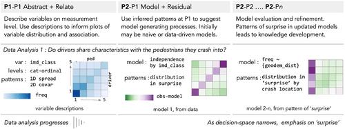
Road safety research is a data-rich field with large social impacts. Like in medical research, the ambition is to build knowledge around risk factors that can save lives. Unlike medical research, road safety research generates empirical findings from messy observational datasets. Records of road crashes contain numerous intersecting categorical variables, dominating patterns that are complicated by confounding and, when conditioning on data to make inferences net of this, observed effects that are subject to uncertainty due to diminishing sample sizes. We demonstrate how visual data analysis approaches can inject rigor into exploratory analysis of such datasets. A framework is presented whereby graphics are used to expose, model and evaluate spatial patterns in observational data, as well as protect against false discovery. Evidence for the framework is presented through an applied data analysis of national crash patterns recorded in STATS19, the main source of road crash information in Great Britain. Our framework moves beyond typical depictions of exploratory data analysis and transfers to complex data analysis decision spaces characteristic of modern geographical analysis.
期刊介绍:
First in its specialty area and one of the most frequently cited publications in geography, Geographical Analysis has, since 1969, presented significant advances in geographical theory, model building, and quantitative methods to geographers and scholars in a wide spectrum of related fields. Traditionally, mathematical and nonmathematical articulations of geographical theory, and statements and discussions of the analytic paradigm are published in the journal. Spatial data analyses and spatial econometrics and statistics are strongly represented.


 分享
分享
 求助内容:
求助内容: 应助结果提醒方式:
 扫码关注我们
