Reda Abdu Yousef El-Qassas, Atef Mohamed Abu-Donia, Ali Elsayed Ali Omar
{"title":"利用遥感和航空地球物理数据圈定与矿床有关的热液蚀变带。案例研究:埃及中东部沙漠El-Bakriya地区","authors":"Reda Abdu Yousef El-Qassas, Atef Mohamed Abu-Donia, Ali Elsayed Ali Omar","doi":"10.1007/s40328-023-00405-y","DOIUrl":null,"url":null,"abstract":"<div><p>El-Bakriya area is situated in the Central Eastern Desert of Egypt. It includes several mineral occurrences and/or deposits. Data from remote sensing and airborne geophysics (gamma-ray and magnetic) were combined to identify the hydrothermal alteration zones and structures related to these occurrences. Various processing of ASTER satellite images revealed fifteen zones of high probability for metallic mineralizations. Airborne gamma-ray spectrometric data clarify K-enrichment zones, which are correlated geologically with the distribution of calc-alkaline, alkali feldspar granites (Younger granites), and calc-alkaline quartzdiorites to granodiorites (Older granites), as well as basement metavolcanics and metasediments. An integrated hydrothermal alteration map was constructed, based on both ASTER remote sensing and airborne gamma-ray spectrometric data. This map delineates some metallic mineral occurrences and/or deposits, which are located in the detected hydrothermal alteration zones. Besides, it displays new potential zones for mineralization, such as: Gabal (G.) El-Shalul, G. El-Bakriya, G. Siwat El-Arsha and G. Umm Bisilla. The geologic and airborne magnetic maps demonstrate five structural lineament trends of E–W, ENE–WSW, NE–SW, NW–SE, and NNW–SSE directions, which might act as pathways to transport the hydrothermal solutions in the study area.</p></div>","PeriodicalId":48965,"journal":{"name":"Acta Geodaetica et Geophysica","volume":"58 1","pages":"71 - 107"},"PeriodicalIF":1.8000,"publicationDate":"2023-02-27","publicationTypes":"Journal Article","fieldsOfStudy":null,"isOpenAccess":false,"openAccessPdf":"https://link.springer.com/content/pdf/10.1007/s40328-023-00405-y.pdf","citationCount":"2","resultStr":"{\"title\":\"Delineation of hydrothermal alteration zones associated with mineral deposits, using remote sensing and airborne geophysics data. A case study: El-Bakriya area, Central Eastern Desert, Egypt\",\"authors\":\"Reda Abdu Yousef El-Qassas, Atef Mohamed Abu-Donia, Ali Elsayed Ali Omar\",\"doi\":\"10.1007/s40328-023-00405-y\",\"DOIUrl\":null,\"url\":null,\"abstract\":\"<div><p>El-Bakriya area is situated in the Central Eastern Desert of Egypt. It includes several mineral occurrences and/or deposits. Data from remote sensing and airborne geophysics (gamma-ray and magnetic) were combined to identify the hydrothermal alteration zones and structures related to these occurrences. Various processing of ASTER satellite images revealed fifteen zones of high probability for metallic mineralizations. Airborne gamma-ray spectrometric data clarify K-enrichment zones, which are correlated geologically with the distribution of calc-alkaline, alkali feldspar granites (Younger granites), and calc-alkaline quartzdiorites to granodiorites (Older granites), as well as basement metavolcanics and metasediments. An integrated hydrothermal alteration map was constructed, based on both ASTER remote sensing and airborne gamma-ray spectrometric data. This map delineates some metallic mineral occurrences and/or deposits, which are located in the detected hydrothermal alteration zones. Besides, it displays new potential zones for mineralization, such as: Gabal (G.) El-Shalul, G. El-Bakriya, G. Siwat El-Arsha and G. Umm Bisilla. The geologic and airborne magnetic maps demonstrate five structural lineament trends of E–W, ENE–WSW, NE–SW, NW–SE, and NNW–SSE directions, which might act as pathways to transport the hydrothermal solutions in the study area.</p></div>\",\"PeriodicalId\":48965,\"journal\":{\"name\":\"Acta Geodaetica et Geophysica\",\"volume\":\"58 1\",\"pages\":\"71 - 107\"},\"PeriodicalIF\":1.8000,\"publicationDate\":\"2023-02-27\",\"publicationTypes\":\"Journal Article\",\"fieldsOfStudy\":null,\"isOpenAccess\":false,\"openAccessPdf\":\"https://link.springer.com/content/pdf/10.1007/s40328-023-00405-y.pdf\",\"citationCount\":\"2\",\"resultStr\":null,\"platform\":\"Semanticscholar\",\"paperid\":null,\"PeriodicalName\":\"Acta Geodaetica et Geophysica\",\"FirstCategoryId\":\"89\",\"ListUrlMain\":\"https://link.springer.com/article/10.1007/s40328-023-00405-y\",\"RegionNum\":4,\"RegionCategory\":\"地球科学\",\"ArticlePicture\":[],\"TitleCN\":null,\"AbstractTextCN\":null,\"PMCID\":null,\"EPubDate\":\"\",\"PubModel\":\"\",\"JCR\":\"Q3\",\"JCRName\":\"GEOCHEMISTRY & GEOPHYSICS\",\"Score\":null,\"Total\":0}","platform":"Semanticscholar","paperid":null,"PeriodicalName":"Acta Geodaetica et Geophysica","FirstCategoryId":"89","ListUrlMain":"https://link.springer.com/article/10.1007/s40328-023-00405-y","RegionNum":4,"RegionCategory":"地球科学","ArticlePicture":[],"TitleCN":null,"AbstractTextCN":null,"PMCID":null,"EPubDate":"","PubModel":"","JCR":"Q3","JCRName":"GEOCHEMISTRY & GEOPHYSICS","Score":null,"Total":0}
引用次数: 2
摘要
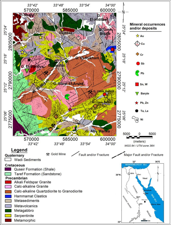
El-Bakriya地区位于埃及的中东部沙漠。它包括几个矿产地和/或矿床。结合遥感和航空地球物理(伽马射线和磁)数据,确定了与这些产状有关的热液蚀变带和构造。对ASTER卫星图像的各种处理揭示了15个高概率金属矿化带。机载伽玛能谱数据明确了钾富集带,与钙碱性、碱长石花岗岩(较年轻花岗岩)、钙碱性石英闪长岩-花岗闪长岩(较老花岗岩)以及基底变质火山和变质沉积岩的分布具有地质相关性。基于ASTER遥感和机载伽玛能谱数据,构建了综合热液蚀变图。这张地图描绘了位于已探测到的热液蚀变带的一些金属矿点和/或矿床。此外,还发现了新的成矿潜力带,如:Gabal (G.)El-Shalul, G. El-Bakriya, G. Siwat El-Arsha和G. Umm Bisilla。地质和航空磁图显示了E-W、ENE-WSW、NE-SW、NW-SE和NNW-SSE五个方向的构造线向,可能是研究区热液运移的通道。
Delineation of hydrothermal alteration zones associated with mineral deposits, using remote sensing and airborne geophysics data. A case study: El-Bakriya area, Central Eastern Desert, Egypt
El-Bakriya area is situated in the Central Eastern Desert of Egypt. It includes several mineral occurrences and/or deposits. Data from remote sensing and airborne geophysics (gamma-ray and magnetic) were combined to identify the hydrothermal alteration zones and structures related to these occurrences. Various processing of ASTER satellite images revealed fifteen zones of high probability for metallic mineralizations. Airborne gamma-ray spectrometric data clarify K-enrichment zones, which are correlated geologically with the distribution of calc-alkaline, alkali feldspar granites (Younger granites), and calc-alkaline quartzdiorites to granodiorites (Older granites), as well as basement metavolcanics and metasediments. An integrated hydrothermal alteration map was constructed, based on both ASTER remote sensing and airborne gamma-ray spectrometric data. This map delineates some metallic mineral occurrences and/or deposits, which are located in the detected hydrothermal alteration zones. Besides, it displays new potential zones for mineralization, such as: Gabal (G.) El-Shalul, G. El-Bakriya, G. Siwat El-Arsha and G. Umm Bisilla. The geologic and airborne magnetic maps demonstrate five structural lineament trends of E–W, ENE–WSW, NE–SW, NW–SE, and NNW–SSE directions, which might act as pathways to transport the hydrothermal solutions in the study area.
期刊介绍:
The journal publishes original research papers in the field of geodesy and geophysics under headings: aeronomy and space physics, electromagnetic studies, geodesy and gravimetry, geodynamics, geomathematics, rock physics, seismology, solid earth physics, history. Papers dealing with problems of the Carpathian region and its surroundings are preferred. Similarly, papers on topics traditionally covered by Hungarian geodesists and geophysicists (e.g. robust estimations, geoid, EM properties of the Earth’s crust, geomagnetic pulsations and seismological risk) are especially welcome.


 分享
分享
 求助内容:
求助内容: 应助结果提醒方式:
 扫码关注我们
