Nik Lomax, Andrew P. Smith, Luke Archer, Alistair Ford, James Virgo
{"title":"预测小区域人口和土地利用变化的开源模型","authors":"Nik Lomax, Andrew P. Smith, Luke Archer, Alistair Ford, James Virgo","doi":"10.1111/gean.12320","DOIUrl":null,"url":null,"abstract":"<p>The size, composition, and spatial distribution of both people and households have a substantial impact on the demand for and development and delivery of infrastructure required to support the population. Infrastructure encompasses a wide range of domains including energy, transport, and water, each of which has its own set of spatial catchments at differing scales. Demographic projections are required to assess potential future demand; however, official projections are usually not provided at a high level of spatial resolution required for infrastructure planning. Furthermore, generating bespoke demographic projections, often incorporating a range of scenarios of possible future demographic change is a specialist, resource intensive job and as such is often missing from infrastructure development projects. In this paper we make the case that such demographic projections should be at the heart of infrastructure planning and present a set of open-source models which can be used to undertake this demographic projection work, thus providing the tools needed to fill the identified gap. We make use of a case study for the United Kingdom to exemplify how a range of scenarios can be assessed using our model.</p>","PeriodicalId":12533,"journal":{"name":"Geographical Analysis","volume":"54 3","pages":"599-622"},"PeriodicalIF":4.3000,"publicationDate":"2022-02-07","publicationTypes":"Journal Article","fieldsOfStudy":null,"isOpenAccess":false,"openAccessPdf":"https://onlinelibrary.wiley.com/doi/epdf/10.1111/gean.12320","citationCount":"7","resultStr":"{\"title\":\"An Open-Source Model for Projecting Small Area Demographic and Land-Use Change\",\"authors\":\"Nik Lomax, Andrew P. Smith, Luke Archer, Alistair Ford, James Virgo\",\"doi\":\"10.1111/gean.12320\",\"DOIUrl\":null,\"url\":null,\"abstract\":\"<p>The size, composition, and spatial distribution of both people and households have a substantial impact on the demand for and development and delivery of infrastructure required to support the population. Infrastructure encompasses a wide range of domains including energy, transport, and water, each of which has its own set of spatial catchments at differing scales. Demographic projections are required to assess potential future demand; however, official projections are usually not provided at a high level of spatial resolution required for infrastructure planning. Furthermore, generating bespoke demographic projections, often incorporating a range of scenarios of possible future demographic change is a specialist, resource intensive job and as such is often missing from infrastructure development projects. In this paper we make the case that such demographic projections should be at the heart of infrastructure planning and present a set of open-source models which can be used to undertake this demographic projection work, thus providing the tools needed to fill the identified gap. We make use of a case study for the United Kingdom to exemplify how a range of scenarios can be assessed using our model.</p>\",\"PeriodicalId\":12533,\"journal\":{\"name\":\"Geographical Analysis\",\"volume\":\"54 3\",\"pages\":\"599-622\"},\"PeriodicalIF\":4.3000,\"publicationDate\":\"2022-02-07\",\"publicationTypes\":\"Journal Article\",\"fieldsOfStudy\":null,\"isOpenAccess\":false,\"openAccessPdf\":\"https://onlinelibrary.wiley.com/doi/epdf/10.1111/gean.12320\",\"citationCount\":\"7\",\"resultStr\":null,\"platform\":\"Semanticscholar\",\"paperid\":null,\"PeriodicalName\":\"Geographical Analysis\",\"FirstCategoryId\":\"89\",\"ListUrlMain\":\"https://onlinelibrary.wiley.com/doi/10.1111/gean.12320\",\"RegionNum\":3,\"RegionCategory\":\"地球科学\",\"ArticlePicture\":[],\"TitleCN\":null,\"AbstractTextCN\":null,\"PMCID\":null,\"EPubDate\":\"\",\"PubModel\":\"\",\"JCR\":\"Q1\",\"JCRName\":\"GEOGRAPHY\",\"Score\":null,\"Total\":0}","platform":"Semanticscholar","paperid":null,"PeriodicalName":"Geographical Analysis","FirstCategoryId":"89","ListUrlMain":"https://onlinelibrary.wiley.com/doi/10.1111/gean.12320","RegionNum":3,"RegionCategory":"地球科学","ArticlePicture":[],"TitleCN":null,"AbstractTextCN":null,"PMCID":null,"EPubDate":"","PubModel":"","JCR":"Q1","JCRName":"GEOGRAPHY","Score":null,"Total":0}
An Open-Source Model for Projecting Small Area Demographic and Land-Use Change
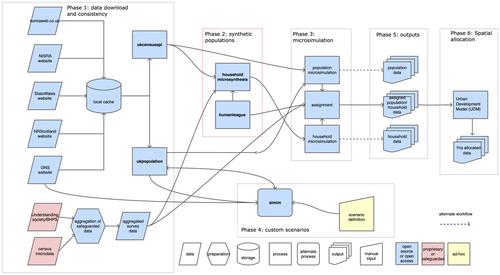
The size, composition, and spatial distribution of both people and households have a substantial impact on the demand for and development and delivery of infrastructure required to support the population. Infrastructure encompasses a wide range of domains including energy, transport, and water, each of which has its own set of spatial catchments at differing scales. Demographic projections are required to assess potential future demand; however, official projections are usually not provided at a high level of spatial resolution required for infrastructure planning. Furthermore, generating bespoke demographic projections, often incorporating a range of scenarios of possible future demographic change is a specialist, resource intensive job and as such is often missing from infrastructure development projects. In this paper we make the case that such demographic projections should be at the heart of infrastructure planning and present a set of open-source models which can be used to undertake this demographic projection work, thus providing the tools needed to fill the identified gap. We make use of a case study for the United Kingdom to exemplify how a range of scenarios can be assessed using our model.
期刊介绍:
First in its specialty area and one of the most frequently cited publications in geography, Geographical Analysis has, since 1969, presented significant advances in geographical theory, model building, and quantitative methods to geographers and scholars in a wide spectrum of related fields. Traditionally, mathematical and nonmathematical articulations of geographical theory, and statements and discussions of the analytic paradigm are published in the journal. Spatial data analyses and spatial econometrics and statistics are strongly represented.


 分享
分享
 求助内容:
求助内容: 应助结果提醒方式:
 扫码关注我们
