Budiman Minasny, Diana Vigah Adetsu, Matt Aitkenhead, Rebekka R. E. Artz, Nikki Baggaley, Alexandra Barthelmes, Amélie Beucher, Jean Caron, Giulia Conchedda, John Connolly, Raphaël Deragon, Chris Evans, Kjetil Fadnes, Dian Fiantis, Zisis Gagkas, Louis Gilet, Alessandro Gimona, Stephan Glatzel, Mogens H. Greve, Wahaj Habib, Kristell Hergoualc’h, Cecilie Hermansen, Darren B. Kidd, Triven Koganti, Dianna Kopansky, David J. Large, Tuula Larmola, Allan Lilly, Haojie Liu, Matthew Marcus, Maarit Middleton, Keith Morrison, Rasmus Jes Petersen, Tristan Quaife, Line Rochefort, Rudiyanto, Linda Toca, Francesco N. Tubiello, Peter Lystbæk Weber, Simon Weldon, Wirastuti Widyatmanti, Jenny Williamson, Dominik Zak
{"title":"从全球到实地测绘和监测泥炭地条件","authors":"Budiman Minasny, Diana Vigah Adetsu, Matt Aitkenhead, Rebekka R. E. Artz, Nikki Baggaley, Alexandra Barthelmes, Amélie Beucher, Jean Caron, Giulia Conchedda, John Connolly, Raphaël Deragon, Chris Evans, Kjetil Fadnes, Dian Fiantis, Zisis Gagkas, Louis Gilet, Alessandro Gimona, Stephan Glatzel, Mogens H. Greve, Wahaj Habib, Kristell Hergoualc’h, Cecilie Hermansen, Darren B. Kidd, Triven Koganti, Dianna Kopansky, David J. Large, Tuula Larmola, Allan Lilly, Haojie Liu, Matthew Marcus, Maarit Middleton, Keith Morrison, Rasmus Jes Petersen, Tristan Quaife, Line Rochefort, Rudiyanto, Linda Toca, Francesco N. Tubiello, Peter Lystbæk Weber, Simon Weldon, Wirastuti Widyatmanti, Jenny Williamson, Dominik Zak","doi":"10.1007/s10533-023-01084-1","DOIUrl":null,"url":null,"abstract":"<div><p>Peatlands cover only 3–4% of the Earth’s surface, but they store nearly 30% of global soil carbon stock. This significant carbon store is under threat as peatlands continue to be degraded at alarming rates around the world. It has prompted countries worldwide to establish regulations to conserve and reduce emissions from this carbon rich ecosystem. For example, the EU has implemented new rules that mandate sustainable management of peatlands, critical to reaching the goal of carbon neutrality by 2050. However, a lack of information on the extent and condition of peatlands has hindered the development of national policies and restoration efforts. This paper reviews the current state of knowledge on mapping and monitoring peatlands from field sites to the globe and identifies areas where further research is needed. It presents an overview of the different methodologies used to map peatlands in nine countries, which vary in definition of peat soil and peatland, mapping coverage, and mapping detail. Whereas mapping peatlands across the world with only one approach is hardly possible, the paper highlights the need for more consistent approaches within regions having comparable peatland types and climates to inform their protection and urgent restoration. The review further summarises various approaches used for monitoring peatland conditions and functions. These include monitoring at the plot scale for degree of humification and stoichiometric ratio, and proximal sensing such as gamma radiometrics and electromagnetic induction at the field to landscape scale for mapping peat thickness and identifying hotspots for greenhouse gas (GHG) emissions. Remote sensing techniques with passive and active sensors at regional to national scale can help in monitoring subsidence rate, water table, peat moisture, landslides, and GHG emissions. Although the use of water table depth as a proxy for interannual GHG emissions from peatlands has been well established, there is no single remote sensing method or data product yet that has been verified beyond local or regional scales. Broader land-use change and fire monitoring at a global scale may further assist national GHG inventory reporting. Monitoring of peatland conditions to evaluate the success of individual restoration schemes still requires field work to assess local proxies combined with remote sensing and modeling. Long-term monitoring is necessary to draw valid conclusions on revegetation outcomes and associated GHG emissions in rewetted peatlands, as their dynamics are not fully understood at the site level. Monitoring vegetation development and hydrology of restored peatlands is needed as a proxy to assess the return of water and changes in nutrient cycling and biodiversity.</p></div>","PeriodicalId":8901,"journal":{"name":"Biogeochemistry","volume":"167 4","pages":"383 - 425"},"PeriodicalIF":3.7000,"publicationDate":"2023-10-10","publicationTypes":"Journal Article","fieldsOfStudy":null,"isOpenAccess":false,"openAccessPdf":"https://link.springer.com/content/pdf/10.1007/s10533-023-01084-1.pdf","citationCount":"0","resultStr":"{\"title\":\"Mapping and monitoring peatland conditions from global to field scale\",\"authors\":\"Budiman Minasny, Diana Vigah Adetsu, Matt Aitkenhead, Rebekka R. E. Artz, Nikki Baggaley, Alexandra Barthelmes, Amélie Beucher, Jean Caron, Giulia Conchedda, John Connolly, Raphaël Deragon, Chris Evans, Kjetil Fadnes, Dian Fiantis, Zisis Gagkas, Louis Gilet, Alessandro Gimona, Stephan Glatzel, Mogens H. Greve, Wahaj Habib, Kristell Hergoualc’h, Cecilie Hermansen, Darren B. Kidd, Triven Koganti, Dianna Kopansky, David J. Large, Tuula Larmola, Allan Lilly, Haojie Liu, Matthew Marcus, Maarit Middleton, Keith Morrison, Rasmus Jes Petersen, Tristan Quaife, Line Rochefort, Rudiyanto, Linda Toca, Francesco N. Tubiello, Peter Lystbæk Weber, Simon Weldon, Wirastuti Widyatmanti, Jenny Williamson, Dominik Zak\",\"doi\":\"10.1007/s10533-023-01084-1\",\"DOIUrl\":null,\"url\":null,\"abstract\":\"<div><p>Peatlands cover only 3–4% of the Earth’s surface, but they store nearly 30% of global soil carbon stock. This significant carbon store is under threat as peatlands continue to be degraded at alarming rates around the world. It has prompted countries worldwide to establish regulations to conserve and reduce emissions from this carbon rich ecosystem. For example, the EU has implemented new rules that mandate sustainable management of peatlands, critical to reaching the goal of carbon neutrality by 2050. However, a lack of information on the extent and condition of peatlands has hindered the development of national policies and restoration efforts. This paper reviews the current state of knowledge on mapping and monitoring peatlands from field sites to the globe and identifies areas where further research is needed. It presents an overview of the different methodologies used to map peatlands in nine countries, which vary in definition of peat soil and peatland, mapping coverage, and mapping detail. Whereas mapping peatlands across the world with only one approach is hardly possible, the paper highlights the need for more consistent approaches within regions having comparable peatland types and climates to inform their protection and urgent restoration. The review further summarises various approaches used for monitoring peatland conditions and functions. These include monitoring at the plot scale for degree of humification and stoichiometric ratio, and proximal sensing such as gamma radiometrics and electromagnetic induction at the field to landscape scale for mapping peat thickness and identifying hotspots for greenhouse gas (GHG) emissions. Remote sensing techniques with passive and active sensors at regional to national scale can help in monitoring subsidence rate, water table, peat moisture, landslides, and GHG emissions. Although the use of water table depth as a proxy for interannual GHG emissions from peatlands has been well established, there is no single remote sensing method or data product yet that has been verified beyond local or regional scales. Broader land-use change and fire monitoring at a global scale may further assist national GHG inventory reporting. Monitoring of peatland conditions to evaluate the success of individual restoration schemes still requires field work to assess local proxies combined with remote sensing and modeling. Long-term monitoring is necessary to draw valid conclusions on revegetation outcomes and associated GHG emissions in rewetted peatlands, as their dynamics are not fully understood at the site level. Monitoring vegetation development and hydrology of restored peatlands is needed as a proxy to assess the return of water and changes in nutrient cycling and biodiversity.</p></div>\",\"PeriodicalId\":8901,\"journal\":{\"name\":\"Biogeochemistry\",\"volume\":\"167 4\",\"pages\":\"383 - 425\"},\"PeriodicalIF\":3.7000,\"publicationDate\":\"2023-10-10\",\"publicationTypes\":\"Journal Article\",\"fieldsOfStudy\":null,\"isOpenAccess\":false,\"openAccessPdf\":\"https://link.springer.com/content/pdf/10.1007/s10533-023-01084-1.pdf\",\"citationCount\":\"0\",\"resultStr\":null,\"platform\":\"Semanticscholar\",\"paperid\":null,\"PeriodicalName\":\"Biogeochemistry\",\"FirstCategoryId\":\"93\",\"ListUrlMain\":\"https://link.springer.com/article/10.1007/s10533-023-01084-1\",\"RegionNum\":3,\"RegionCategory\":\"环境科学与生态学\",\"ArticlePicture\":[],\"TitleCN\":null,\"AbstractTextCN\":null,\"PMCID\":null,\"EPubDate\":\"\",\"PubModel\":\"\",\"JCR\":\"Q2\",\"JCRName\":\"ENVIRONMENTAL SCIENCES\",\"Score\":null,\"Total\":0}","platform":"Semanticscholar","paperid":null,"PeriodicalName":"Biogeochemistry","FirstCategoryId":"93","ListUrlMain":"https://link.springer.com/article/10.1007/s10533-023-01084-1","RegionNum":3,"RegionCategory":"环境科学与生态学","ArticlePicture":[],"TitleCN":null,"AbstractTextCN":null,"PMCID":null,"EPubDate":"","PubModel":"","JCR":"Q2","JCRName":"ENVIRONMENTAL SCIENCES","Score":null,"Total":0}
Mapping and monitoring peatland conditions from global to field scale
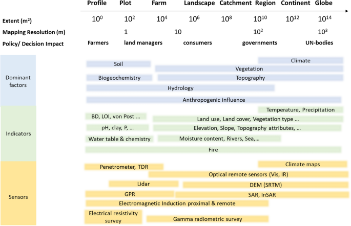
Peatlands cover only 3–4% of the Earth’s surface, but they store nearly 30% of global soil carbon stock. This significant carbon store is under threat as peatlands continue to be degraded at alarming rates around the world. It has prompted countries worldwide to establish regulations to conserve and reduce emissions from this carbon rich ecosystem. For example, the EU has implemented new rules that mandate sustainable management of peatlands, critical to reaching the goal of carbon neutrality by 2050. However, a lack of information on the extent and condition of peatlands has hindered the development of national policies and restoration efforts. This paper reviews the current state of knowledge on mapping and monitoring peatlands from field sites to the globe and identifies areas where further research is needed. It presents an overview of the different methodologies used to map peatlands in nine countries, which vary in definition of peat soil and peatland, mapping coverage, and mapping detail. Whereas mapping peatlands across the world with only one approach is hardly possible, the paper highlights the need for more consistent approaches within regions having comparable peatland types and climates to inform their protection and urgent restoration. The review further summarises various approaches used for monitoring peatland conditions and functions. These include monitoring at the plot scale for degree of humification and stoichiometric ratio, and proximal sensing such as gamma radiometrics and electromagnetic induction at the field to landscape scale for mapping peat thickness and identifying hotspots for greenhouse gas (GHG) emissions. Remote sensing techniques with passive and active sensors at regional to national scale can help in monitoring subsidence rate, water table, peat moisture, landslides, and GHG emissions. Although the use of water table depth as a proxy for interannual GHG emissions from peatlands has been well established, there is no single remote sensing method or data product yet that has been verified beyond local or regional scales. Broader land-use change and fire monitoring at a global scale may further assist national GHG inventory reporting. Monitoring of peatland conditions to evaluate the success of individual restoration schemes still requires field work to assess local proxies combined with remote sensing and modeling. Long-term monitoring is necessary to draw valid conclusions on revegetation outcomes and associated GHG emissions in rewetted peatlands, as their dynamics are not fully understood at the site level. Monitoring vegetation development and hydrology of restored peatlands is needed as a proxy to assess the return of water and changes in nutrient cycling and biodiversity.
期刊介绍:
Biogeochemistry publishes original and synthetic papers dealing with biotic controls on the chemistry of the environment, or with the geochemical control of the structure and function of ecosystems. Cycles are considered, either of individual elements or of specific classes of natural or anthropogenic compounds in ecosystems. Particular emphasis is given to coupled interactions of element cycles. The journal spans from the molecular to global scales to elucidate the mechanisms driving patterns in biogeochemical cycles through space and time. Studies on both natural and artificial ecosystems are published when they contribute to a general understanding of biogeochemistry.


 分享
分享
 求助内容:
求助内容: 应助结果提醒方式:
 扫码关注我们
