I. P. Babayants, A. A. Baryakh, V. O. Mikhailov, E. P. Timoshkina, M. S. Volkova, S. A. Khairetdinov
{"title":"Monitoring of Subsidence in Berezniki City (Perm Krai) by SAR Interferometry. Method of Persistent Scatterers","authors":"I. P. Babayants, A. A. Baryakh, V. O. Mikhailov, E. P. Timoshkina, M. S. Volkova, S. A. Khairetdinov","doi":"10.1134/S1069351323060034","DOIUrl":null,"url":null,"abstract":"<p>The paper presents the results of the processing of satellite radar images acquired by the TerraSAR-X satellite using the persistent scatterer method for analyzing the subsidence of the earth’s surface over potash mines in the city of Berezniki, Perm Krai. A sequence of processing procedures in the GAMMA Software package (Gamma Remote Sensing AG, Switzerland) is presented, which showed good results in the conditions of this territory. A comparison is made with the results obtained earlier by summation of interferograms. In contrast to the methods of persistent scatterers, the summation is performed without analyzing displacements in time. The noisy time series obtained by the summation are not rejected, so the displacement maps cover the study area more evenly. In the persistent scatterer method, the time series is analyzed using a variety of criteria, so the subsidence rates are estimated more reliably. In the areas where the results were obtained by summation and the persistent scatterer method, the subsidence rates are in good agreement. The persistent scatterer method has made it possible to estimate displacements in certain areas separated by vast incoherent woodlands, on which interferograms lose their coherence. At the same time, a new subsidence area was identified with an average rate of subvertical displacements up to 75 mm/year and, in some areas, up to 100 mm/year, which, according to data for 2020 and 2018, was not detected. The subsidence here should be clarified based on the images for subsequent years or using surface thechniques. The time series also show the deceleration of subsidence in spring on persistent scatterers located on buildings and infrastructure. We associate the total spring deceleration of subsidence by 3–5 cm not with underground but with seasonal factors, specifically with the heating of buildings in the spring. Other reasons are also possible, but the main one is that, in areas with a moderate subsidence rate, this effect can lead to some underestimation of the average subsidence rate. A detailed study of the time series for subsidence makes it possible to identify areas requiring special attention. Most of the subsidence occurs more or less evenly; in a significant part of the territory, the subsidence rate in 2021 has decreased. This indicates the effectiveness of the measures taken to protect the ground infrastructure. Within the city area, the acceleration of subsidence was found only at the beginning of Lenin Avenue. SAR interferometry is an effective tool for studying subsidence processes in the city of Berezniki. This method significantly complements geodetic works, since it provides data on vast areas that cannot be covered by detailed ground measurements. In addition, part of the closed territories becomes dangerous for ground works, so there is no alternative to satellite technologies.</p>","PeriodicalId":602,"journal":{"name":"Izvestiya, Physics of the Solid Earth","volume":"59 6","pages":"1066 - 1078"},"PeriodicalIF":1.0000,"publicationDate":"2023-11-28","publicationTypes":"Journal Article","fieldsOfStudy":null,"isOpenAccess":false,"openAccessPdf":"","citationCount":"0","resultStr":null,"platform":"Semanticscholar","paperid":null,"PeriodicalName":"Izvestiya, Physics of the Solid Earth","FirstCategoryId":"89","ListUrlMain":"https://link.springer.com/article/10.1134/S1069351323060034","RegionNum":4,"RegionCategory":"地球科学","ArticlePicture":[],"TitleCN":null,"AbstractTextCN":null,"PMCID":null,"EPubDate":"","PubModel":"","JCR":"Q4","JCRName":"GEOCHEMISTRY & GEOPHYSICS","Score":null,"Total":0}
引用次数: 0
Abstract
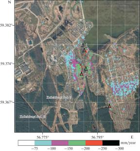
The paper presents the results of the processing of satellite radar images acquired by the TerraSAR-X satellite using the persistent scatterer method for analyzing the subsidence of the earth’s surface over potash mines in the city of Berezniki, Perm Krai. A sequence of processing procedures in the GAMMA Software package (Gamma Remote Sensing AG, Switzerland) is presented, which showed good results in the conditions of this territory. A comparison is made with the results obtained earlier by summation of interferograms. In contrast to the methods of persistent scatterers, the summation is performed without analyzing displacements in time. The noisy time series obtained by the summation are not rejected, so the displacement maps cover the study area more evenly. In the persistent scatterer method, the time series is analyzed using a variety of criteria, so the subsidence rates are estimated more reliably. In the areas where the results were obtained by summation and the persistent scatterer method, the subsidence rates are in good agreement. The persistent scatterer method has made it possible to estimate displacements in certain areas separated by vast incoherent woodlands, on which interferograms lose their coherence. At the same time, a new subsidence area was identified with an average rate of subvertical displacements up to 75 mm/year and, in some areas, up to 100 mm/year, which, according to data for 2020 and 2018, was not detected. The subsidence here should be clarified based on the images for subsequent years or using surface thechniques. The time series also show the deceleration of subsidence in spring on persistent scatterers located on buildings and infrastructure. We associate the total spring deceleration of subsidence by 3–5 cm not with underground but with seasonal factors, specifically with the heating of buildings in the spring. Other reasons are also possible, but the main one is that, in areas with a moderate subsidence rate, this effect can lead to some underestimation of the average subsidence rate. A detailed study of the time series for subsidence makes it possible to identify areas requiring special attention. Most of the subsidence occurs more or less evenly; in a significant part of the territory, the subsidence rate in 2021 has decreased. This indicates the effectiveness of the measures taken to protect the ground infrastructure. Within the city area, the acceleration of subsidence was found only at the beginning of Lenin Avenue. SAR interferometry is an effective tool for studying subsidence processes in the city of Berezniki. This method significantly complements geodetic works, since it provides data on vast areas that cannot be covered by detailed ground measurements. In addition, part of the closed territories becomes dangerous for ground works, so there is no alternative to satellite technologies.
期刊介绍:
Izvestiya, Physics of the Solid Earth is an international peer reviewed journal that publishes results of original theoretical and experimental research in relevant areas of the physics of the Earth''s interior and applied geophysics. The journal welcomes manuscripts from all countries in the English or Russian language.


 分享
分享
 求助内容:
求助内容: 应助结果提醒方式:
 扫码关注我们
