{"title":"Integrated workflow incorporating the Hurst exponent and interval inversion for evaluating groundwater formations","authors":"Moataz M. G. Abdelrahman, Norbert P. Szabó","doi":"10.1007/s10040-023-02752-0","DOIUrl":null,"url":null,"abstract":"<p>A novel well-log-analysis approach is presented for an improved prediction of petrophysical properties in groundwater formations. Geophysical well logs are simultaneously processed for quantifying the lithology, storage capacity, and water flow parameters. A fully automated data processing workflow is proposed, the feasibility of which is assured by an appropriate starting model set by the joint application of factor analysis and the Hurst exponent, and a solution of a highly overdetermined inverse problem. The Hurst exponent is used for zone boundary detection, which assists the series expansion-based interval inversion method applied for estimation of the petrophysical parameters of clastic formations. The hydraulic conductivity as a well log is directly derived from the inversion results. The workflow is tested using both synthetic data contaminated with 5% Gaussian distributed noise and real data collected from a thermal water well in Baktalórántháza, eastern Hungary. At the test site, the Hurst exponent extracted from the wireline logs allows one to divide the processed interval into subzones around the Pleistocene-Miocene boundary. The observed wireline logs are inverted to estimate the volumetric parameters (porosity, shale content, water saturation, etc.) of the same zones. The predicted parameters, including hydraulic conductivity, reveal that Pleistocene sediments contain good aquifers with formation quality varying with depth. The shale volume and hydraulic conductivity logs show a proper match with the core data, which confirms the results of the comprehensive analysis. The suggested workflow is recommended for the evaluation of groundwater formations located in different depth domains, from unsaturated sediments to geothermal reservoirs.</p>","PeriodicalId":13013,"journal":{"name":"Hydrogeology Journal","volume":"72 1","pages":""},"PeriodicalIF":2.3000,"publicationDate":"2023-12-11","publicationTypes":"Journal Article","fieldsOfStudy":null,"isOpenAccess":false,"openAccessPdf":"","citationCount":"0","resultStr":null,"platform":"Semanticscholar","paperid":null,"PeriodicalName":"Hydrogeology Journal","FirstCategoryId":"89","ListUrlMain":"https://doi.org/10.1007/s10040-023-02752-0","RegionNum":3,"RegionCategory":"地球科学","ArticlePicture":[],"TitleCN":null,"AbstractTextCN":null,"PMCID":null,"EPubDate":"","PubModel":"","JCR":"Q2","JCRName":"GEOSCIENCES, MULTIDISCIPLINARY","Score":null,"Total":0}
引用次数: 0
Abstract
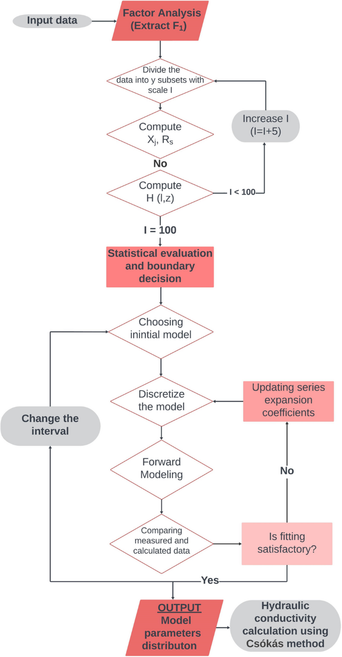
A novel well-log-analysis approach is presented for an improved prediction of petrophysical properties in groundwater formations. Geophysical well logs are simultaneously processed for quantifying the lithology, storage capacity, and water flow parameters. A fully automated data processing workflow is proposed, the feasibility of which is assured by an appropriate starting model set by the joint application of factor analysis and the Hurst exponent, and a solution of a highly overdetermined inverse problem. The Hurst exponent is used for zone boundary detection, which assists the series expansion-based interval inversion method applied for estimation of the petrophysical parameters of clastic formations. The hydraulic conductivity as a well log is directly derived from the inversion results. The workflow is tested using both synthetic data contaminated with 5% Gaussian distributed noise and real data collected from a thermal water well in Baktalórántháza, eastern Hungary. At the test site, the Hurst exponent extracted from the wireline logs allows one to divide the processed interval into subzones around the Pleistocene-Miocene boundary. The observed wireline logs are inverted to estimate the volumetric parameters (porosity, shale content, water saturation, etc.) of the same zones. The predicted parameters, including hydraulic conductivity, reveal that Pleistocene sediments contain good aquifers with formation quality varying with depth. The shale volume and hydraulic conductivity logs show a proper match with the core data, which confirms the results of the comprehensive analysis. The suggested workflow is recommended for the evaluation of groundwater formations located in different depth domains, from unsaturated sediments to geothermal reservoirs.
期刊介绍:
Hydrogeology Journal was founded in 1992 to foster understanding of hydrogeology; to describe worldwide progress in hydrogeology; and to provide an accessible forum for scientists, researchers, engineers, and practitioners in developing and industrialized countries.
Since then, the journal has earned a large worldwide readership. Its peer-reviewed research articles integrate subsurface hydrology and geology with supporting disciplines: geochemistry, geophysics, geomorphology, geobiology, surface-water hydrology, tectonics, numerical modeling, economics, and sociology.


 分享
分享
 求助内容:
求助内容: 应助结果提醒方式:
 扫码关注我们
