Assessing erosion and sediment removal in the Isla Salamanca coastal barrier: implications for the Barranquilla-Ciénaga highway and coastal marine biodiversity – Colombia
{"title":"Assessing erosion and sediment removal in the Isla Salamanca coastal barrier: implications for the Barranquilla-Ciénaga highway and coastal marine biodiversity – Colombia","authors":"Rogério Portantiolo Manzolli, Mulfor Cantillo-Sabalza, Luana Portz","doi":"10.1007/s00367-024-00765-6","DOIUrl":null,"url":null,"abstract":"<p>The Isla Salamanca coastal barrier on the Colombian Caribbean coast faces significant erosion, driven by climate change-induced, sea level rise and human activities such as highway construction. The Barranquilla-Ciénaga highway, particularly at kilometers 19 and 29, is at risk, with severe consequences for the region’s socio-economic and environmental well-being. Human interventions like the highway construction and seawall installations have disrupted the natural coastal dynamics, leading to increased erosion rates. The study, conducted between 2004 and 2021, reveals that the Isla Salamanca coastal barrier is experiencing substantial transgression, with erosion rates peaking at -16.1 m·yr<sup>− 1</sup>. The highway protection measures, with seawall construction, have proven inadequate, exacerbating erosion downstream. The mangrove loss due to hydrological changes and increased salinity is further threatening the fragile ecosystem. The research emphasizes the importance of considering biodiversity loss in the context of rapid erosion rates. The region, declared a Ramsar Site and Biosphere Reserve, hosts vital ecosystems like mangroves and dunes, whose destruction negatively impacts marine biodiversity. The study suggests the relocation of the highway, acknowledging the challenges of preserving wetlands and mangroves in the process. Balancing the need for infrastructure with ecological preservation is essential, and the study proposes comprehensive solutions, including shoreline management, ecosystem-based protection, and community involvement. The goal is to mitigate erosion’s adverse effects on biodiversity, habitat integrity, and the overall health of this ecologically sensitive region.</p>","PeriodicalId":12500,"journal":{"name":"Geo-Marine Letters","volume":"141 1","pages":""},"PeriodicalIF":1.4000,"publicationDate":"2024-02-22","publicationTypes":"Journal Article","fieldsOfStudy":null,"isOpenAccess":false,"openAccessPdf":"","citationCount":"0","resultStr":null,"platform":"Semanticscholar","paperid":null,"PeriodicalName":"Geo-Marine Letters","FirstCategoryId":"89","ListUrlMain":"https://doi.org/10.1007/s00367-024-00765-6","RegionNum":4,"RegionCategory":"地球科学","ArticlePicture":[],"TitleCN":null,"AbstractTextCN":null,"PMCID":null,"EPubDate":"","PubModel":"","JCR":"Q3","JCRName":"GEOSCIENCES, MULTIDISCIPLINARY","Score":null,"Total":0}
引用次数: 0
Abstract
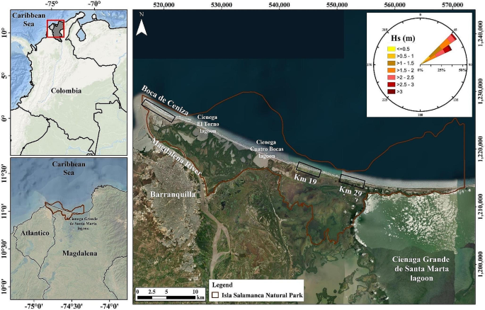
The Isla Salamanca coastal barrier on the Colombian Caribbean coast faces significant erosion, driven by climate change-induced, sea level rise and human activities such as highway construction. The Barranquilla-Ciénaga highway, particularly at kilometers 19 and 29, is at risk, with severe consequences for the region’s socio-economic and environmental well-being. Human interventions like the highway construction and seawall installations have disrupted the natural coastal dynamics, leading to increased erosion rates. The study, conducted between 2004 and 2021, reveals that the Isla Salamanca coastal barrier is experiencing substantial transgression, with erosion rates peaking at -16.1 m·yr− 1. The highway protection measures, with seawall construction, have proven inadequate, exacerbating erosion downstream. The mangrove loss due to hydrological changes and increased salinity is further threatening the fragile ecosystem. The research emphasizes the importance of considering biodiversity loss in the context of rapid erosion rates. The region, declared a Ramsar Site and Biosphere Reserve, hosts vital ecosystems like mangroves and dunes, whose destruction negatively impacts marine biodiversity. The study suggests the relocation of the highway, acknowledging the challenges of preserving wetlands and mangroves in the process. Balancing the need for infrastructure with ecological preservation is essential, and the study proposes comprehensive solutions, including shoreline management, ecosystem-based protection, and community involvement. The goal is to mitigate erosion’s adverse effects on biodiversity, habitat integrity, and the overall health of this ecologically sensitive region.
期刊介绍:
Geo-Marine Letters is an international peer-reviewed journal focussing on the rapid publication of concise original studies and reviews dealing with processes, products and techniques in marine geology, geophysics, and geochemistry. Coverage spans
- structural geology, including plate tectonics of recent active and passive margins
- sea-bed morphology, physiography and morphodynamics
- sediment transport, depositional processes and sedimentary facies analysis
- stratigraphy, basin analysis and paleoenvironmental reconstruction
- sea-level history, paleoproductivity, gas hydrates, salt domes and brines
- sediment-water interaction and organism-sediment relationships
- geochemical tracers, stable isotopes and authigenic mineral formation
- geotechnical properties and application of new geo-marine techniques, and more.
In addition to regular articles, reviews, discussion/reply articles and technical papers, Geo-Marine Letters welcomes contributions by guest editors in the form of conference/workshop proceedings, or bundles of papers dealing with specific themes.


 分享
分享
 求助内容:
求助内容: 应助结果提醒方式:
 扫码关注我们
