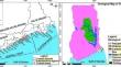
{"title":"Shoreline change and coastal erosion: an analysis of long-term change and adaptation strategies in coastal Ghana","authors":"Johnson Ankrah","doi":"10.1007/s00367-024-00774-5","DOIUrl":null,"url":null,"abstract":"<p>This study analysed long-term shoreline change, the influence of erosion, and adaptation strategies in coastal Ghana. The change between 1972 and 2021 was analysed using Landsat satellite images and the Digital Shoreline Analysis System (DSAS v.5.0), and adaptation strategies were revealed through field observations. The End Point Rate (EPR), Linear Regression Rate (LRR), and Weighted Linear Regression (WLR) were used to estimate the rate of change, whereas the Net Shoreline Movement (NSM) and Shoreline Change Envelope (SCE) were used to calculate the distances of change. The coefficient of shoreline armouring (K) index was used to evaluate the grade of artificial or human interventions on the coast. The erosion rates for the EPR (− 107.6 m/year, or 95.0%) and LRR (− 75.7 m/year, or 99.3%) were higher than the accretion rates of (28.5 m/year, or 5.0%) and (33.6 m/year, or 0.7%), respectively. The NSM recorded maximum erosion (− 14,080 to − 10,840 m) and accretion (1107 to 2135 m) with an average distance of − 4943.1 m. The SCE estimated a maximum (14,080.5 m) and minimum (813.8 m) distances with an average distance change of 5557.9 m. The central coast experienced erosion at average rates of − 119.0 m/yr, − 89.6 m/yr, and − 94.0 m/yr, according to EPR, LRR, and WLR statistics. The eastern coast observed lower erosion rates than the central coast, with rates of − 75.3 m/yr, − 53.2 m/yr, and − 41.9 m/yr for the EPR, LRR, and WLR statistics, respectively. Since 1972, there has been a significant increase in artificial coastal structures on Ghana's central and eastern coasts. The central coast has reached a maximal level of shoreline armouring index, while the eastern coast has reached a minimal level. Although hard protective measures have been implemented on most parts of the coast for adaptation, improved policy initiatives on soft and nature-based protection measures are encouraged based on their favourable ecological impact and economic effectiveness.</p>","PeriodicalId":12500,"journal":{"name":"Geo-Marine Letters","volume":"15 1","pages":""},"PeriodicalIF":1.4000,"publicationDate":"2024-07-11","publicationTypes":"Journal Article","fieldsOfStudy":null,"isOpenAccess":false,"openAccessPdf":"","citationCount":"0","resultStr":null,"platform":"Semanticscholar","paperid":null,"PeriodicalName":"Geo-Marine Letters","FirstCategoryId":"89","ListUrlMain":"https://doi.org/10.1007/s00367-024-00774-5","RegionNum":4,"RegionCategory":"地球科学","ArticlePicture":[],"TitleCN":null,"AbstractTextCN":null,"PMCID":null,"EPubDate":"","PubModel":"","JCR":"Q3","JCRName":"GEOSCIENCES, MULTIDISCIPLINARY","Score":null,"Total":0}
引用次数: 0
Abstract
This study analysed long-term shoreline change, the influence of erosion, and adaptation strategies in coastal Ghana. The change between 1972 and 2021 was analysed using Landsat satellite images and the Digital Shoreline Analysis System (DSAS v.5.0), and adaptation strategies were revealed through field observations. The End Point Rate (EPR), Linear Regression Rate (LRR), and Weighted Linear Regression (WLR) were used to estimate the rate of change, whereas the Net Shoreline Movement (NSM) and Shoreline Change Envelope (SCE) were used to calculate the distances of change. The coefficient of shoreline armouring (K) index was used to evaluate the grade of artificial or human interventions on the coast. The erosion rates for the EPR (− 107.6 m/year, or 95.0%) and LRR (− 75.7 m/year, or 99.3%) were higher than the accretion rates of (28.5 m/year, or 5.0%) and (33.6 m/year, or 0.7%), respectively. The NSM recorded maximum erosion (− 14,080 to − 10,840 m) and accretion (1107 to 2135 m) with an average distance of − 4943.1 m. The SCE estimated a maximum (14,080.5 m) and minimum (813.8 m) distances with an average distance change of 5557.9 m. The central coast experienced erosion at average rates of − 119.0 m/yr, − 89.6 m/yr, and − 94.0 m/yr, according to EPR, LRR, and WLR statistics. The eastern coast observed lower erosion rates than the central coast, with rates of − 75.3 m/yr, − 53.2 m/yr, and − 41.9 m/yr for the EPR, LRR, and WLR statistics, respectively. Since 1972, there has been a significant increase in artificial coastal structures on Ghana's central and eastern coasts. The central coast has reached a maximal level of shoreline armouring index, while the eastern coast has reached a minimal level. Although hard protective measures have been implemented on most parts of the coast for adaptation, improved policy initiatives on soft and nature-based protection measures are encouraged based on their favourable ecological impact and economic effectiveness.
期刊介绍:
Geo-Marine Letters is an international peer-reviewed journal focussing on the rapid publication of concise original studies and reviews dealing with processes, products and techniques in marine geology, geophysics, and geochemistry. Coverage spans
- structural geology, including plate tectonics of recent active and passive margins
- sea-bed morphology, physiography and morphodynamics
- sediment transport, depositional processes and sedimentary facies analysis
- stratigraphy, basin analysis and paleoenvironmental reconstruction
- sea-level history, paleoproductivity, gas hydrates, salt domes and brines
- sediment-water interaction and organism-sediment relationships
- geochemical tracers, stable isotopes and authigenic mineral formation
- geotechnical properties and application of new geo-marine techniques, and more.
In addition to regular articles, reviews, discussion/reply articles and technical papers, Geo-Marine Letters welcomes contributions by guest editors in the form of conference/workshop proceedings, or bundles of papers dealing with specific themes.


 分享
分享
 求助内容:
求助内容: 应助结果提醒方式:
 扫码关注我们
