Wenchao Huangfu, Haijun Qiu, Peng Cui, Dongdong Yang, Ya Liu, Mohib Ullah, Ulrich Kamp
{"title":"Automated extraction of mining-induced ground fissures using deep learning and object-based image classification","authors":"Wenchao Huangfu, Haijun Qiu, Peng Cui, Dongdong Yang, Ya Liu, Mohib Ullah, Ulrich Kamp","doi":"10.1002/esp.5824","DOIUrl":null,"url":null,"abstract":"<p>Accurate extraction of ground fissures caused by intense coal mining has the potential to significantly improve the efficiency of environmental monitoring in mining areas. However, the extraction results using previous methods have often exhibited issues of discontinuity and substantial deviation from ground truth data, resulting in low extraction accuracy. In this study, a novel approach, ENVINet5-OBIC, for extracting ground fissures in mining areas is proposed, which integrates object-based image classification (OBIC) with the pixel-based deep learning model ENVINet5. ENVINet5-OBIC uses OBIC to segment high-resolution unmanned aerial vehicle (UAV) images across different scales, effectively considering shape, texture and correlative information between adjacent pixels. Furthermore, by utilizing homogeneous objects as building blocks, it establishes a deep learning model for the automated extraction of ground fissures. Experimental results show that ENVINet5-OBIC performs better when compared with OBIC, U-Net, PSPNet and ENVINet5 methods in terms of continuity, accuracy and error reduction. In addition, the ground fissure area extracted by ENVINet5-OBIC closely aligns with ground truth data. This study provides a more effective method for automatic extraction of ground fissures, which improves the efficiency of environmental monitoring in mining areas.</p>","PeriodicalId":11408,"journal":{"name":"Earth Surface Processes and Landforms","volume":"49 7","pages":"2189-2204"},"PeriodicalIF":2.7000,"publicationDate":"2024-03-25","publicationTypes":"Journal Article","fieldsOfStudy":null,"isOpenAccess":false,"openAccessPdf":"","citationCount":"0","resultStr":null,"platform":"Semanticscholar","paperid":null,"PeriodicalName":"Earth Surface Processes and Landforms","FirstCategoryId":"89","ListUrlMain":"https://onlinelibrary.wiley.com/doi/10.1002/esp.5824","RegionNum":3,"RegionCategory":"地球科学","ArticlePicture":[],"TitleCN":null,"AbstractTextCN":null,"PMCID":null,"EPubDate":"","PubModel":"","JCR":"Q2","JCRName":"GEOGRAPHY, PHYSICAL","Score":null,"Total":0}
引用次数: 0
Abstract
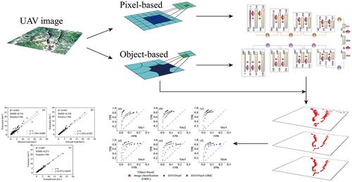
Accurate extraction of ground fissures caused by intense coal mining has the potential to significantly improve the efficiency of environmental monitoring in mining areas. However, the extraction results using previous methods have often exhibited issues of discontinuity and substantial deviation from ground truth data, resulting in low extraction accuracy. In this study, a novel approach, ENVINet5-OBIC, for extracting ground fissures in mining areas is proposed, which integrates object-based image classification (OBIC) with the pixel-based deep learning model ENVINet5. ENVINet5-OBIC uses OBIC to segment high-resolution unmanned aerial vehicle (UAV) images across different scales, effectively considering shape, texture and correlative information between adjacent pixels. Furthermore, by utilizing homogeneous objects as building blocks, it establishes a deep learning model for the automated extraction of ground fissures. Experimental results show that ENVINet5-OBIC performs better when compared with OBIC, U-Net, PSPNet and ENVINet5 methods in terms of continuity, accuracy and error reduction. In addition, the ground fissure area extracted by ENVINet5-OBIC closely aligns with ground truth data. This study provides a more effective method for automatic extraction of ground fissures, which improves the efficiency of environmental monitoring in mining areas.
期刊介绍:
Earth Surface Processes and Landforms is an interdisciplinary international journal concerned with:
the interactions between surface processes and landforms and landscapes;
that lead to physical, chemical and biological changes; and which in turn create;
current landscapes and the geological record of past landscapes.
Its focus is core to both physical geographical and geological communities, and also the wider geosciences


 分享
分享
 求助内容:
求助内容: 应助结果提醒方式:
 扫码关注我们
