Peng Li, Shu Li, Zhenhong Li, Cunren Liang, Houjie Wang
{"title":"Detailed detection and extraction of estuarine tidal channels with multispectral and full-polarised SAR remote sensing","authors":"Peng Li, Shu Li, Zhenhong Li, Cunren Liang, Houjie Wang","doi":"10.1002/esp.5950","DOIUrl":null,"url":null,"abstract":"<p>Estuarine tidal channels are active geomorphic units in tidal flats. However, accurate information on the spatiotemporal changes in tidal channel systems remains scarce. The width of the tidal channels may vary from several kilometres to tens of centimetres. Monitoring tidal channel evolution is complicated because of periodic tidal scouring, anthropogenic activities and sea level rise. In this study, we propose a synergetic classification method to detect and extract morphological information of estuarine tidal channels with a spatial resolution of up to 3 m by fusing PlanetScope multispectral data with C-band GaoFen-3 fully polarised Synthetic Aperture Radar (SAR) data and machine learning algorithms. Considering the Yellow River Estuary as an example, the spectral features, vegetation and water index, polarisation and texture features derived from the multispectral and SAR images were selected as input data for classifiers according to feature importance ranking. Comparison to the maximum likelihood, and support vector machine classifiers, the synergetic classification with random forest showed the best performance, with an overall accuracy of 99.6%. Based on these results, the total number of tidal channels in the Yellow River Estuary reached 872, with a total length of 348.8 km. The spatiotemporal changes in the central axis over the last 4 years (2019–2022) suggest that the evolution of tidal channels was mainly controlled by ocean dynamics and anthropogenic activities. This method provides a cost-effective alternative to accurately map tidal channel systems in global estuarine and coastal zones and helps to quantitatively describe their morphological evolution, stability and drivers.</p>","PeriodicalId":11408,"journal":{"name":"Earth Surface Processes and Landforms","volume":"49 12","pages":"3968-3988"},"PeriodicalIF":2.7000,"publicationDate":"2024-08-08","publicationTypes":"Journal Article","fieldsOfStudy":null,"isOpenAccess":false,"openAccessPdf":"","citationCount":"0","resultStr":null,"platform":"Semanticscholar","paperid":null,"PeriodicalName":"Earth Surface Processes and Landforms","FirstCategoryId":"89","ListUrlMain":"https://onlinelibrary.wiley.com/doi/10.1002/esp.5950","RegionNum":3,"RegionCategory":"地球科学","ArticlePicture":[],"TitleCN":null,"AbstractTextCN":null,"PMCID":null,"EPubDate":"","PubModel":"","JCR":"Q2","JCRName":"GEOGRAPHY, PHYSICAL","Score":null,"Total":0}
引用次数: 0
Abstract
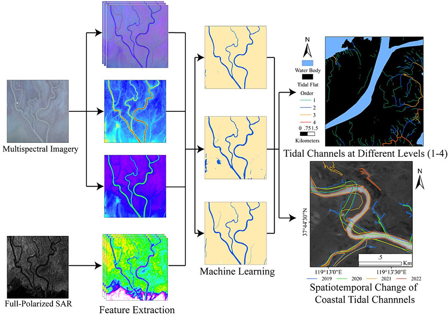
Estuarine tidal channels are active geomorphic units in tidal flats. However, accurate information on the spatiotemporal changes in tidal channel systems remains scarce. The width of the tidal channels may vary from several kilometres to tens of centimetres. Monitoring tidal channel evolution is complicated because of periodic tidal scouring, anthropogenic activities and sea level rise. In this study, we propose a synergetic classification method to detect and extract morphological information of estuarine tidal channels with a spatial resolution of up to 3 m by fusing PlanetScope multispectral data with C-band GaoFen-3 fully polarised Synthetic Aperture Radar (SAR) data and machine learning algorithms. Considering the Yellow River Estuary as an example, the spectral features, vegetation and water index, polarisation and texture features derived from the multispectral and SAR images were selected as input data for classifiers according to feature importance ranking. Comparison to the maximum likelihood, and support vector machine classifiers, the synergetic classification with random forest showed the best performance, with an overall accuracy of 99.6%. Based on these results, the total number of tidal channels in the Yellow River Estuary reached 872, with a total length of 348.8 km. The spatiotemporal changes in the central axis over the last 4 years (2019–2022) suggest that the evolution of tidal channels was mainly controlled by ocean dynamics and anthropogenic activities. This method provides a cost-effective alternative to accurately map tidal channel systems in global estuarine and coastal zones and helps to quantitatively describe their morphological evolution, stability and drivers.
期刊介绍:
Earth Surface Processes and Landforms is an interdisciplinary international journal concerned with:
the interactions between surface processes and landforms and landscapes;
that lead to physical, chemical and biological changes; and which in turn create;
current landscapes and the geological record of past landscapes.
Its focus is core to both physical geographical and geological communities, and also the wider geosciences


 分享
分享
 求助内容:
求助内容: 应助结果提醒方式:
 扫码关注我们
