Umakanta Pradhan, Uma Sankar Panda, Pravakar Mishra, Subrat Naik, Mehmuna Begum, M. V. Ramana Murthy
{"title":"Cusps development after cyclone (Vardah) along the east coast of India: data and theories","authors":"Umakanta Pradhan, Uma Sankar Panda, Pravakar Mishra, Subrat Naik, Mehmuna Begum, M. V. Ramana Murthy","doi":"10.1007/s00367-024-00766-5","DOIUrl":null,"url":null,"abstract":"<p>Cusp formation and related processes are well-studied all over the world, but research along the Indian coast is scanty and fragmentary. This paper provides a detailed description of the geomorphology, characteristics, and development of a series of cusps after the cyclone “Vardah” crossed along the east coast of India on 12<sup>th</sup> December 2016. Observations of instantaneous shoreline, cusp dimension, and related processes such as wind, wave, littoral environmental observation (LEO), sediment texture, and total suspended sediment load in the surf zone were obtained for three discrete observations spanning 20 days, revealing a clear insight into the post cyclonic beach processes and the cusp development. The cusp development shows an accretionary environment (12 m in 20 days) and sediment characteristics show to coincide with cusp evolution as coarser sediment at horns than the bays. After the storms, the mean grain size decreases and the sorting value increases along the coast. The spacing of observed cusps ranged from 15 to 40 m with a dominant spacing of 20–30 m (80%) while cusp depths are mostly 4–6 m (55%) and range from 2 to 8 m. The cusps are formed under the influence of low wave energy, anticipated from numerical modeling study; wave height (H<sub>s</sub>) is 0.6 m, wave period (T<sub>s</sub>) is 6 s, and wave direction is 90 deg. The present study reveals that cusp formation along this region is a better fit with self-organization theory.</p>","PeriodicalId":12500,"journal":{"name":"Geo-Marine Letters","volume":"41 1","pages":""},"PeriodicalIF":1.4000,"publicationDate":"2024-04-12","publicationTypes":"Journal Article","fieldsOfStudy":null,"isOpenAccess":false,"openAccessPdf":"","citationCount":"0","resultStr":null,"platform":"Semanticscholar","paperid":null,"PeriodicalName":"Geo-Marine Letters","FirstCategoryId":"89","ListUrlMain":"https://doi.org/10.1007/s00367-024-00766-5","RegionNum":4,"RegionCategory":"地球科学","ArticlePicture":[],"TitleCN":null,"AbstractTextCN":null,"PMCID":null,"EPubDate":"","PubModel":"","JCR":"Q3","JCRName":"GEOSCIENCES, MULTIDISCIPLINARY","Score":null,"Total":0}
引用次数: 0
Abstract
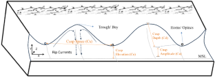
Cusp formation and related processes are well-studied all over the world, but research along the Indian coast is scanty and fragmentary. This paper provides a detailed description of the geomorphology, characteristics, and development of a series of cusps after the cyclone “Vardah” crossed along the east coast of India on 12th December 2016. Observations of instantaneous shoreline, cusp dimension, and related processes such as wind, wave, littoral environmental observation (LEO), sediment texture, and total suspended sediment load in the surf zone were obtained for three discrete observations spanning 20 days, revealing a clear insight into the post cyclonic beach processes and the cusp development. The cusp development shows an accretionary environment (12 m in 20 days) and sediment characteristics show to coincide with cusp evolution as coarser sediment at horns than the bays. After the storms, the mean grain size decreases and the sorting value increases along the coast. The spacing of observed cusps ranged from 15 to 40 m with a dominant spacing of 20–30 m (80%) while cusp depths are mostly 4–6 m (55%) and range from 2 to 8 m. The cusps are formed under the influence of low wave energy, anticipated from numerical modeling study; wave height (Hs) is 0.6 m, wave period (Ts) is 6 s, and wave direction is 90 deg. The present study reveals that cusp formation along this region is a better fit with self-organization theory.
期刊介绍:
Geo-Marine Letters is an international peer-reviewed journal focussing on the rapid publication of concise original studies and reviews dealing with processes, products and techniques in marine geology, geophysics, and geochemistry. Coverage spans
- structural geology, including plate tectonics of recent active and passive margins
- sea-bed morphology, physiography and morphodynamics
- sediment transport, depositional processes and sedimentary facies analysis
- stratigraphy, basin analysis and paleoenvironmental reconstruction
- sea-level history, paleoproductivity, gas hydrates, salt domes and brines
- sediment-water interaction and organism-sediment relationships
- geochemical tracers, stable isotopes and authigenic mineral formation
- geotechnical properties and application of new geo-marine techniques, and more.
In addition to regular articles, reviews, discussion/reply articles and technical papers, Geo-Marine Letters welcomes contributions by guest editors in the form of conference/workshop proceedings, or bundles of papers dealing with specific themes.


 分享
分享
 求助内容:
求助内容: 应助结果提醒方式:
 扫码关注我们
