{"title":"Runoff modeling with various unit-hydrograph approaches for Sarada river basin, India","authors":"Ganapathi Dandupati, Suryanarayana Chodavarapu, Ramesh Naidu Chalumuri, Ajay Ahirwar","doi":"10.1007/s12517-024-11951-2","DOIUrl":null,"url":null,"abstract":"<div><p>Hydrological studies of river basins are necessary for sustainable planning and management of drinking and irrigation water supplies. Continuous rainfall-runoff HEC-HMS models require the selection of loss and transform methods. The soil moisture accounting (SMA) loss approach is more prevalent since it can reflect water movement in wet and dry conditions. However, the transform method for a basin should be chosen based on the model’s accuracy in replicating observed flows. The present study is aimed at developing the continuous rainfall-runoff HEC-HMS model for the Sarada river basin in India using SMA as the loss method and to suggest the best transform method by assessing the performance of three distinct unit hydrograph (UH) transform methods (SCS-UH, Clark-UH, and Snyder-UH). The SMA parameters for each transform method were optimized using the built-in optimization trail manager and observed river flow data from the three existing reservoirs (Raiwad, Konam, and Pedderu). Each model reach was routed using the Muskingum method, and the linear reservoir approach was used to compute percolation losses. The Hargreaves method was used to estimate evapotranspiration. Model calibration and validation were performed for the years 2009–18 and 2019–20, respectively, using observed river flow data and Mandal-level meteorological data. Sensitivity analysis conducted on SMA loss parameters showed that the maximum infiltration rate and maximum impervious parameters were the most sensitive. Results indicate that the performances of the SCS-UH transform method are superior to other methods for all three reservoirs. During model validation, when compared to the Snyder-UH and Clark-UH techniques, the SCS-UH method reduced root mean square error by 59% and 26% for the Raiwada, 12% and 10% for the Konam, and 19% and 19% for the Pedderu reservoirs, respectively. The model can be used to predict floods in the river basin’s downstream region and plan water conservation infrastructure.</p></div>","PeriodicalId":476,"journal":{"name":"Arabian Journal of Geosciences","volume":"17 5","pages":""},"PeriodicalIF":1.8270,"publicationDate":"2024-04-11","publicationTypes":"Journal Article","fieldsOfStudy":null,"isOpenAccess":false,"openAccessPdf":"","citationCount":"0","resultStr":null,"platform":"Semanticscholar","paperid":null,"PeriodicalName":"Arabian Journal of Geosciences","FirstCategoryId":"1085","ListUrlMain":"https://link.springer.com/article/10.1007/s12517-024-11951-2","RegionNum":0,"RegionCategory":null,"ArticlePicture":[],"TitleCN":null,"AbstractTextCN":null,"PMCID":null,"EPubDate":"","PubModel":"","JCR":"Q2","JCRName":"Earth and Planetary Sciences","Score":null,"Total":0}
引用次数: 0
Abstract
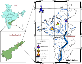
Hydrological studies of river basins are necessary for sustainable planning and management of drinking and irrigation water supplies. Continuous rainfall-runoff HEC-HMS models require the selection of loss and transform methods. The soil moisture accounting (SMA) loss approach is more prevalent since it can reflect water movement in wet and dry conditions. However, the transform method for a basin should be chosen based on the model’s accuracy in replicating observed flows. The present study is aimed at developing the continuous rainfall-runoff HEC-HMS model for the Sarada river basin in India using SMA as the loss method and to suggest the best transform method by assessing the performance of three distinct unit hydrograph (UH) transform methods (SCS-UH, Clark-UH, and Snyder-UH). The SMA parameters for each transform method were optimized using the built-in optimization trail manager and observed river flow data from the three existing reservoirs (Raiwad, Konam, and Pedderu). Each model reach was routed using the Muskingum method, and the linear reservoir approach was used to compute percolation losses. The Hargreaves method was used to estimate evapotranspiration. Model calibration and validation were performed for the years 2009–18 and 2019–20, respectively, using observed river flow data and Mandal-level meteorological data. Sensitivity analysis conducted on SMA loss parameters showed that the maximum infiltration rate and maximum impervious parameters were the most sensitive. Results indicate that the performances of the SCS-UH transform method are superior to other methods for all three reservoirs. During model validation, when compared to the Snyder-UH and Clark-UH techniques, the SCS-UH method reduced root mean square error by 59% and 26% for the Raiwada, 12% and 10% for the Konam, and 19% and 19% for the Pedderu reservoirs, respectively. The model can be used to predict floods in the river basin’s downstream region and plan water conservation infrastructure.
期刊介绍:
The Arabian Journal of Geosciences is the official journal of the Saudi Society for Geosciences and publishes peer-reviewed original and review articles on the entire range of Earth Science themes, focused on, but not limited to, those that have regional significance to the Middle East and the Euro-Mediterranean Zone.
Key topics therefore include; geology, hydrogeology, earth system science, petroleum sciences, geophysics, seismology and crustal structures, tectonics, sedimentology, palaeontology, metamorphic and igneous petrology, natural hazards, environmental sciences and sustainable development, geoarchaeology, geomorphology, paleo-environment studies, oceanography, atmospheric sciences, GIS and remote sensing, geodesy, mineralogy, volcanology, geochemistry and metallogenesis.


 分享
分享
 求助内容:
求助内容: 应助结果提醒方式:
 扫码关注我们
