Marian E. Mateling, Claire Pettersen, Kyle Mattingly, Sarah Ringerud
{"title":"Merged and Gridded GPM and Atmospheric River Data Product","authors":"Marian E. Mateling, Claire Pettersen, Kyle Mattingly, Sarah Ringerud","doi":"10.1029/2023EA003333","DOIUrl":null,"url":null,"abstract":"<p>The Global Precipitation Measurement (GPM) Mission Core Observatory satellite launched in 2014 as a joint mission between National Aeronautics and Space Administration (NASA) and JAXA. Global Precipitation Measurement (GPM) has, since that time, provided continuous, valuable dual-frequency radar and passive microwave radiometer observations. Here, we introduce a gridded data set of collocated GPM Core Observatory observational products merged with a reanalysis-derived Atmospheric river (AR) data set in the North Atlantic and North Pacific sectors. The three data sets that are merged and gridded are: (a) the NASA Goddard Profiling (GPROF) precipitation product, which uses GPM passive microwave radiometer observations to derive surface precipitation rates, (b) a water vapor data product derived from the GPM Core Observatory radiometer, provided by Remote Sensing Systems (RSS), and (c) the Mattingly et al. (2018, https://doi.org/10.1029/2018jd028714) AR data set that is specifically tuned to the high-latitude regions. This novel merged data set spans from May 2014 to December 2022 with plans to update annually through 2026 at minimum. This gridded product combines RSS passive water vapor and precipitation estimates with coincident AR detection. This data product benefits the scientific community by providing (a) user-friendly gridded satellite data compared to standard satellite data sets, while maintaining high temporal resolution, and (b) coincident satellite observations to assess the link between ARs and precipitation.</p>","PeriodicalId":54286,"journal":{"name":"Earth and Space Science","volume":"11 5","pages":""},"PeriodicalIF":2.6000,"publicationDate":"2024-05-23","publicationTypes":"Journal Article","fieldsOfStudy":null,"isOpenAccess":false,"openAccessPdf":"https://onlinelibrary.wiley.com/doi/epdf/10.1029/2023EA003333","citationCount":"0","resultStr":null,"platform":"Semanticscholar","paperid":null,"PeriodicalName":"Earth and Space Science","FirstCategoryId":"89","ListUrlMain":"https://agupubs.onlinelibrary.wiley.com/doi/10.1029/2023EA003333","RegionNum":3,"RegionCategory":"地球科学","ArticlePicture":[],"TitleCN":null,"AbstractTextCN":null,"PMCID":null,"EPubDate":"","PubModel":"","JCR":"Q2","JCRName":"ASTRONOMY & ASTROPHYSICS","Score":null,"Total":0}
引用次数: 0
Abstract
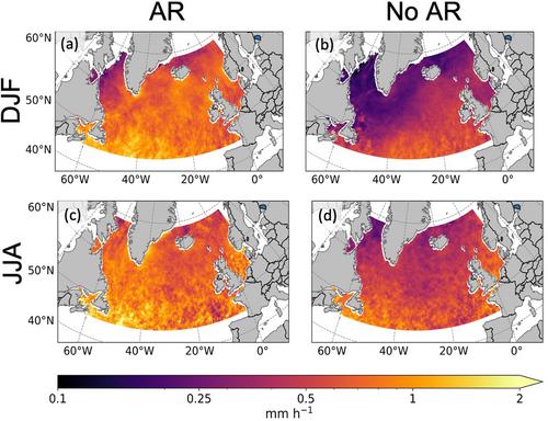
The Global Precipitation Measurement (GPM) Mission Core Observatory satellite launched in 2014 as a joint mission between National Aeronautics and Space Administration (NASA) and JAXA. Global Precipitation Measurement (GPM) has, since that time, provided continuous, valuable dual-frequency radar and passive microwave radiometer observations. Here, we introduce a gridded data set of collocated GPM Core Observatory observational products merged with a reanalysis-derived Atmospheric river (AR) data set in the North Atlantic and North Pacific sectors. The three data sets that are merged and gridded are: (a) the NASA Goddard Profiling (GPROF) precipitation product, which uses GPM passive microwave radiometer observations to derive surface precipitation rates, (b) a water vapor data product derived from the GPM Core Observatory radiometer, provided by Remote Sensing Systems (RSS), and (c) the Mattingly et al. (2018, https://doi.org/10.1029/2018jd028714) AR data set that is specifically tuned to the high-latitude regions. This novel merged data set spans from May 2014 to December 2022 with plans to update annually through 2026 at minimum. This gridded product combines RSS passive water vapor and precipitation estimates with coincident AR detection. This data product benefits the scientific community by providing (a) user-friendly gridded satellite data compared to standard satellite data sets, while maintaining high temporal resolution, and (b) coincident satellite observations to assess the link between ARs and precipitation.
期刊介绍:
Marking AGU’s second new open access journal in the last 12 months, Earth and Space Science is the only journal that reflects the expansive range of science represented by AGU’s 62,000 members, including all of the Earth, planetary, and space sciences, and related fields in environmental science, geoengineering, space engineering, and biogeochemistry.


 分享
分享
 求助内容:
求助内容: 应助结果提醒方式:
 扫码关注我们
