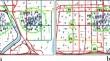
{"title":"Identifying and recommending taxi hotspots in spatio-temporal space","authors":"Saurabh Mishra, Sonia Khetarpaul","doi":"10.1007/s10707-024-00524-w","DOIUrl":null,"url":null,"abstract":"<p>The GPS-driven mobile application-based ride-hailing systems, e.g., Uber and Ola, have become integral to daily life and natural transport choices for urban commuters. However, there is an imbalance between demand or pick-up requests and supply or drop-off requests in any area. The city planners and the researchers are working hard to balance this gap in demand and supply situation for taxi requests. The existing approaches have mainly focused on clustering the spatial regions to identify the hotspots, which refer to the locations with a high demand for pick-up requests. This study determined that if the hotspots focus on clustering high demand for pick-up requests, most of the hotspots pivot near the city center or in the two-three spatial regions, ignoring the other parts of the city. This paper (An earlier version of this paper was presented at the Australasian Database Conference and was published in its Proceedings: https://link.springer.com/chapter/10.1007/978-3-030-69377-0_10) presents a hotspot detection method that uses a dominating set problem-based solution in spatial-temporal space, which covers high-density taxi pick-up demand regions and covers those parts of the city with a moderate density of taxi pick-up demands during different hours of the day. The paper proposes algorithms based on <i>k</i>-hop dominating set; their performance is evaluated using real-world datasets and proves the edge over the existing state-of-the-art methods. It will also reduce the waiting time for customers and drivers looking for their subsequent pick-up requests. Therefore, this would maximize their profit and help improve their services.</p>","PeriodicalId":55109,"journal":{"name":"Geoinformatica","volume":"27 3 1","pages":""},"PeriodicalIF":2.6000,"publicationDate":"2024-05-25","publicationTypes":"Journal Article","fieldsOfStudy":null,"isOpenAccess":false,"openAccessPdf":"","citationCount":"0","resultStr":null,"platform":"Semanticscholar","paperid":null,"PeriodicalName":"Geoinformatica","FirstCategoryId":"94","ListUrlMain":"https://doi.org/10.1007/s10707-024-00524-w","RegionNum":4,"RegionCategory":"计算机科学","ArticlePicture":[],"TitleCN":null,"AbstractTextCN":null,"PMCID":null,"EPubDate":"","PubModel":"","JCR":"Q3","JCRName":"COMPUTER SCIENCE, INFORMATION SYSTEMS","Score":null,"Total":0}
引用次数: 0
Abstract
The GPS-driven mobile application-based ride-hailing systems, e.g., Uber and Ola, have become integral to daily life and natural transport choices for urban commuters. However, there is an imbalance between demand or pick-up requests and supply or drop-off requests in any area. The city planners and the researchers are working hard to balance this gap in demand and supply situation for taxi requests. The existing approaches have mainly focused on clustering the spatial regions to identify the hotspots, which refer to the locations with a high demand for pick-up requests. This study determined that if the hotspots focus on clustering high demand for pick-up requests, most of the hotspots pivot near the city center or in the two-three spatial regions, ignoring the other parts of the city. This paper (An earlier version of this paper was presented at the Australasian Database Conference and was published in its Proceedings: https://link.springer.com/chapter/10.1007/978-3-030-69377-0_10) presents a hotspot detection method that uses a dominating set problem-based solution in spatial-temporal space, which covers high-density taxi pick-up demand regions and covers those parts of the city with a moderate density of taxi pick-up demands during different hours of the day. The paper proposes algorithms based on k-hop dominating set; their performance is evaluated using real-world datasets and proves the edge over the existing state-of-the-art methods. It will also reduce the waiting time for customers and drivers looking for their subsequent pick-up requests. Therefore, this would maximize their profit and help improve their services.
期刊介绍:
GeoInformatica is located at the confluence of two rapidly advancing domains: Computer Science and Geographic Information Science; nowadays, Earth studies use more and more sophisticated computing theory and tools, and computer processing of Earth observations through Geographic Information Systems (GIS) attracts a great deal of attention from governmental, industrial and research worlds.
This journal aims to promote the most innovative results coming from the research in the field of computer science applied to geographic information systems. Thus, GeoInformatica provides an effective forum for disseminating original and fundamental research and experience in the rapidly advancing area of the use of computer science for spatial studies.


 分享
分享
 求助内容:
求助内容: 应助结果提醒方式:
 扫码关注我们
