{"title":"GIS-based multi-criteria decision analysis for groundwater dam site selection in an arid and semi-arid region of Algeria","authors":"Abdelkader Hamlat, Khedidja Hamdi, Djamel Eddine Kissari, Chadli Bendjedid Kadri, Azeddine Guidoum, Mohamed Sekkoum","doi":"10.1016/j.gsd.2024.101231","DOIUrl":null,"url":null,"abstract":"<div><p>Securing reliable water resources in arid and semi-arid regions poses a significant challenge for decision-makers, especially under recent droughts and projected climate change. This need is particularly acute in the M'zi Wadi basin, located in the north-central part of Algeria, where its surface water projects are challenged by low and erratic rainfall coupled with high water evaporation, adversely impacting its water resources sustainability. Implementing water harvesting techniques in such arid regions, specifically groundwater dams, can be regarded as an effective water scarcity adaptation strategy, and their effectiveness is dependent on the optimal site selection which must consider many complex criteria. The paper aims to identify potential sites for groundwater dams in the M'zi Wadi basin using a multi-criteria decision-making approach in a GIS environment based on seven socio-economic and natural factors such as rainfall, stream order, land use/land cover (LULC), geology, Topographic wetness index (TWI), and distances from faults and villages. The results showed that approximately 1.27% of the M'zi Wadi basin area is highly suitable for groundwater dam siting. Four candidate sites were identified as having favourable conditions for installing new groundwater dams based on field and geophysical survey data conducted along the alluvial aquifer of the M'zi Wadi basin, and the remaining areas were deemed unsuitable due to specific constraints. The suitability of the selected sites was validated through a comparative analysis with existing groundwater dams. The results of the present study could offer valuable insights for decision-makers at all levels, facilitating informed judgments during the initial planning of groundwater dam construction. Furthermore, the methodology can be replicated in other data-scarce regions under similar arid climate conditions.</p></div>","PeriodicalId":37879,"journal":{"name":"Groundwater for Sustainable Development","volume":null,"pages":null},"PeriodicalIF":4.9000,"publicationDate":"2024-06-15","publicationTypes":"Journal Article","fieldsOfStudy":null,"isOpenAccess":false,"openAccessPdf":"","citationCount":"0","resultStr":null,"platform":"Semanticscholar","paperid":null,"PeriodicalName":"Groundwater for Sustainable Development","FirstCategoryId":"1085","ListUrlMain":"https://www.sciencedirect.com/science/article/pii/S2352801X24001541","RegionNum":0,"RegionCategory":null,"ArticlePicture":[],"TitleCN":null,"AbstractTextCN":null,"PMCID":null,"EPubDate":"","PubModel":"","JCR":"Q2","JCRName":"ENGINEERING, ENVIRONMENTAL","Score":null,"Total":0}
引用次数: 0
Abstract
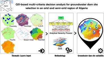
Securing reliable water resources in arid and semi-arid regions poses a significant challenge for decision-makers, especially under recent droughts and projected climate change. This need is particularly acute in the M'zi Wadi basin, located in the north-central part of Algeria, where its surface water projects are challenged by low and erratic rainfall coupled with high water evaporation, adversely impacting its water resources sustainability. Implementing water harvesting techniques in such arid regions, specifically groundwater dams, can be regarded as an effective water scarcity adaptation strategy, and their effectiveness is dependent on the optimal site selection which must consider many complex criteria. The paper aims to identify potential sites for groundwater dams in the M'zi Wadi basin using a multi-criteria decision-making approach in a GIS environment based on seven socio-economic and natural factors such as rainfall, stream order, land use/land cover (LULC), geology, Topographic wetness index (TWI), and distances from faults and villages. The results showed that approximately 1.27% of the M'zi Wadi basin area is highly suitable for groundwater dam siting. Four candidate sites were identified as having favourable conditions for installing new groundwater dams based on field and geophysical survey data conducted along the alluvial aquifer of the M'zi Wadi basin, and the remaining areas were deemed unsuitable due to specific constraints. The suitability of the selected sites was validated through a comparative analysis with existing groundwater dams. The results of the present study could offer valuable insights for decision-makers at all levels, facilitating informed judgments during the initial planning of groundwater dam construction. Furthermore, the methodology can be replicated in other data-scarce regions under similar arid climate conditions.
期刊介绍:
Groundwater for Sustainable Development is directed to different stakeholders and professionals, including government and non-governmental organizations, international funding agencies, universities, public water institutions, public health and other public/private sector professionals, and other relevant institutions. It is aimed at professionals, academics and students in the fields of disciplines such as: groundwater and its connection to surface hydrology and environment, soil sciences, engineering, ecology, microbiology, atmospheric sciences, analytical chemistry, hydro-engineering, water technology, environmental ethics, economics, public health, policy, as well as social sciences, legal disciplines, or any other area connected with water issues. The objectives of this journal are to facilitate: • The improvement of effective and sustainable management of water resources across the globe. • The improvement of human access to groundwater resources in adequate quantity and good quality. • The meeting of the increasing demand for drinking and irrigation water needed for food security to contribute to a social and economically sound human development. • The creation of a global inter- and multidisciplinary platform and forum to improve our understanding of groundwater resources and to advocate their effective and sustainable management and protection against contamination. • Interdisciplinary information exchange and to stimulate scientific research in the fields of groundwater related sciences and social and health sciences required to achieve the United Nations Millennium Development Goals for sustainable development.


 分享
分享
 求助内容:
求助内容: 应助结果提醒方式:
 扫码关注我们
