The aquifer system of the Salado-Juramento fluvial megafan distal plain, Argentina: an integrated approach of geological, hydrogeological and numerical models
Maria Belen Thalmeier, Leticia Rodríguez, Javier Heredia, Daniela Kröhling, Ernesto Brunetto
{"title":"The aquifer system of the Salado-Juramento fluvial megafan distal plain, Argentina: an integrated approach of geological, hydrogeological and numerical models","authors":"Maria Belen Thalmeier, Leticia Rodríguez, Javier Heredia, Daniela Kröhling, Ernesto Brunetto","doi":"10.1007/s10040-024-02808-9","DOIUrl":null,"url":null,"abstract":"<p>The hydrogeological system of the Bajos Submeridionales (BBSS), a large plain in Argentina, remains insufficiently understood. The BBSS is located in the distal part of one of the largest fluvial megafans in the Gran Chaco Plain, South America. The BBSS is sparsely populated and frequently affected by extreme drought and flood events that cause severe problems to communities and economic production. This research aims to improve the current hydrogeologic understanding of the system through the development of the first integrated hydrogeological model for the region. The BBSS hydrogeological system exhibits a relatively simple hydraulic behavior at a regional scale. The definitions of four hydrogeological units (HU) were based on the simplification of the sedimentary column for the area, representing the fundamental characteristics of the dynamics of groundwater flows, their interconnections and the interactions with surface-water bodies and the atmosphere through direct recharge. Due to the lack of available transient data, the hydrogeological conceptual model was numerically tested under a steady-state flow regime. The numerical model was instrumental to test the plausibility of the proposed conceptual model and evaluate the water balance components for the entire aquifer system. The numerical model highlighted the role of stream/aquifer interaction as a primary discharge mechanism and the occurrence of flow exchanges between HUs. A newly installed groundwater monitolring network will support future transient simulations to investigate the temporal evolution of the system and explore management interventions to achieve environmental sustainability criteria.</p>","PeriodicalId":13013,"journal":{"name":"Hydrogeology Journal","volume":"15 1","pages":""},"PeriodicalIF":2.3000,"publicationDate":"2024-07-05","publicationTypes":"Journal Article","fieldsOfStudy":null,"isOpenAccess":false,"openAccessPdf":"","citationCount":"0","resultStr":null,"platform":"Semanticscholar","paperid":null,"PeriodicalName":"Hydrogeology Journal","FirstCategoryId":"89","ListUrlMain":"https://doi.org/10.1007/s10040-024-02808-9","RegionNum":3,"RegionCategory":"地球科学","ArticlePicture":[],"TitleCN":null,"AbstractTextCN":null,"PMCID":null,"EPubDate":"","PubModel":"","JCR":"Q2","JCRName":"GEOSCIENCES, MULTIDISCIPLINARY","Score":null,"Total":0}
引用次数: 0
Abstract
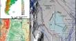
The hydrogeological system of the Bajos Submeridionales (BBSS), a large plain in Argentina, remains insufficiently understood. The BBSS is located in the distal part of one of the largest fluvial megafans in the Gran Chaco Plain, South America. The BBSS is sparsely populated and frequently affected by extreme drought and flood events that cause severe problems to communities and economic production. This research aims to improve the current hydrogeologic understanding of the system through the development of the first integrated hydrogeological model for the region. The BBSS hydrogeological system exhibits a relatively simple hydraulic behavior at a regional scale. The definitions of four hydrogeological units (HU) were based on the simplification of the sedimentary column for the area, representing the fundamental characteristics of the dynamics of groundwater flows, their interconnections and the interactions with surface-water bodies and the atmosphere through direct recharge. Due to the lack of available transient data, the hydrogeological conceptual model was numerically tested under a steady-state flow regime. The numerical model was instrumental to test the plausibility of the proposed conceptual model and evaluate the water balance components for the entire aquifer system. The numerical model highlighted the role of stream/aquifer interaction as a primary discharge mechanism and the occurrence of flow exchanges between HUs. A newly installed groundwater monitolring network will support future transient simulations to investigate the temporal evolution of the system and explore management interventions to achieve environmental sustainability criteria.
期刊介绍:
Hydrogeology Journal was founded in 1992 to foster understanding of hydrogeology; to describe worldwide progress in hydrogeology; and to provide an accessible forum for scientists, researchers, engineers, and practitioners in developing and industrialized countries.
Since then, the journal has earned a large worldwide readership. Its peer-reviewed research articles integrate subsurface hydrology and geology with supporting disciplines: geochemistry, geophysics, geomorphology, geobiology, surface-water hydrology, tectonics, numerical modeling, economics, and sociology.


 分享
分享
 求助内容:
求助内容: 应助结果提醒方式:
 扫码关注我们
