Jaime R. Goode, Robert J. Hawley, Robert H. Lewis, Bethany Mulhall
{"title":"Rapid geomorphic assessment walkabouts as a tool for stream mitigation monitoring","authors":"Jaime R. Goode, Robert J. Hawley, Robert H. Lewis, Bethany Mulhall","doi":"10.1111/1752-1688.13222","DOIUrl":null,"url":null,"abstract":"<p>Monitoring of compensatory stream mitigation projects conventionally relies on spatially discrete geometric data and habitat assessments collected from representative reaches. Project success is evaluated by extrapolating site-scale metrics such as rapid bioassessment protocol (RBP) scores and time-series changes in width-to-depth ratios to adjacent reaches. For example, an excellent RBP score at one location is used to infer excellent habitat in nearby reaches. This paper compares spatially discrete and continuous monitoring data from 38 km of restored stream length on a stream mitigation project in central Kentucky to document how conventional site-level metrics may not represent conditions in adjacent reaches, particularly on projects plagued by post-construction geomorphic instability (e.g., headcut migration, propagation of bank erosion, and chute cutoff formation). Over a 5-year monitoring period, rapid visual assessment walkabouts documented project-scale geomorphic process trajectories that were not captured by conventional site-specific monitoring. Early detection of geomorphic instability from this rapid monitoring approach facilitated cost-effective and tailored adaptive management (e.g., planting of live stakes to arrest bank erosion). Full-census walkabouts can thereby help to improve mitigation credit valuation, enhance long-term habitat protection, and facilitate successful steam restoration outcomes.</p>","PeriodicalId":17234,"journal":{"name":"Journal of The American Water Resources Association","volume":"60 5","pages":"991-1007"},"PeriodicalIF":2.2000,"publicationDate":"2024-07-09","publicationTypes":"Journal Article","fieldsOfStudy":null,"isOpenAccess":false,"openAccessPdf":"https://onlinelibrary.wiley.com/doi/epdf/10.1111/1752-1688.13222","citationCount":"0","resultStr":null,"platform":"Semanticscholar","paperid":null,"PeriodicalName":"Journal of The American Water Resources Association","FirstCategoryId":"93","ListUrlMain":"https://onlinelibrary.wiley.com/doi/10.1111/1752-1688.13222","RegionNum":4,"RegionCategory":"环境科学与生态学","ArticlePicture":[],"TitleCN":null,"AbstractTextCN":null,"PMCID":null,"EPubDate":"","PubModel":"","JCR":"Q3","JCRName":"ENGINEERING, ENVIRONMENTAL","Score":null,"Total":0}
引用次数: 0
Abstract
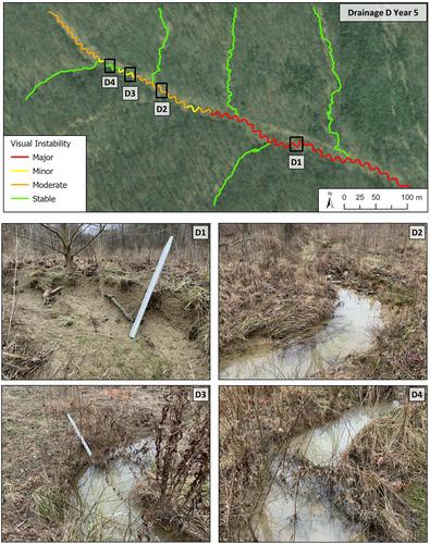
Monitoring of compensatory stream mitigation projects conventionally relies on spatially discrete geometric data and habitat assessments collected from representative reaches. Project success is evaluated by extrapolating site-scale metrics such as rapid bioassessment protocol (RBP) scores and time-series changes in width-to-depth ratios to adjacent reaches. For example, an excellent RBP score at one location is used to infer excellent habitat in nearby reaches. This paper compares spatially discrete and continuous monitoring data from 38 km of restored stream length on a stream mitigation project in central Kentucky to document how conventional site-level metrics may not represent conditions in adjacent reaches, particularly on projects plagued by post-construction geomorphic instability (e.g., headcut migration, propagation of bank erosion, and chute cutoff formation). Over a 5-year monitoring period, rapid visual assessment walkabouts documented project-scale geomorphic process trajectories that were not captured by conventional site-specific monitoring. Early detection of geomorphic instability from this rapid monitoring approach facilitated cost-effective and tailored adaptive management (e.g., planting of live stakes to arrest bank erosion). Full-census walkabouts can thereby help to improve mitigation credit valuation, enhance long-term habitat protection, and facilitate successful steam restoration outcomes.
期刊介绍:
JAWRA seeks to be the preeminent scholarly publication on multidisciplinary water resources issues. JAWRA papers present ideas derived from multiple disciplines woven together to give insight into a critical water issue, or are based primarily upon a single discipline with important applications to other disciplines. Papers often cover the topics of recent AWRA conferences such as riparian ecology, geographic information systems, adaptive management, and water policy.
JAWRA authors present work within their disciplinary fields to a broader audience. Our Associate Editors and reviewers reflect this diversity to ensure a knowledgeable and fair review of a broad range of topics. We particularly encourage submissions of papers which impart a ''take home message'' our readers can use.


 分享
分享
 求助内容:
求助内容: 应助结果提醒方式:
 扫码关注我们
