Jinliang Zhang, Zhong Lu, Chaoqun Li, Guoping Lei, Ziyang Yu, Kuo Li
{"title":"Estimation of groundwater-level changes based on GRACE satellite and GLDAS assimilation data in the Songnen Plain, China","authors":"Jinliang Zhang, Zhong Lu, Chaoqun Li, Guoping Lei, Ziyang Yu, Kuo Li","doi":"10.1007/s10040-024-02815-w","DOIUrl":null,"url":null,"abstract":"<p>As an important large-scale commercial grain production base in China, the Songnen Plain has a particular need for groundwater resources. Here, the groundwater-storage (GWS) changes estimated by the Gravity Recovery and Climate Experiment (GRACE) and Global Land Data Assimilation System (GLDAS) data are input to the MIKE SHE model to correct the errors of remote sensing data. Through this, the simulation of groundwater levels at the large and medium regional scales (Songnen Plain) from 2005 to 2018 was achieved. The analysis reveals that the groundwater data derived from the estimation of GRACE and GLDAS data have a strong correlation with the measured data, with a correlation coefficient of 0.82 between GRACE and measured groundwater data and a correlation coefficient of –0.76 between GLDAS and measured groundwater data. In addition, estimated groundwater data were added to the MIKE SHE model to simulate Songnen Plain groundwater levels between 2005 and 2018. The simulation results indicate that the correlation between simulated and observed groundwater level data is substantially greater than that between inverted and observed groundwater data. Over the past 15 years, the Songnen Plain’s groundwater levels have exhibited a general upward trend of ~0.028 m/year. The groundwater levels in the northeastern, central, and western portions of the Songnen Plain are falling at a rate of ~0.144 m/year, while the groundwater levels in the southern and northwestern portions of the Songnen Plain and areas near the river are rising at a rate of ~0.513 m/year.</p>","PeriodicalId":13013,"journal":{"name":"Hydrogeology Journal","volume":"30 1","pages":""},"PeriodicalIF":2.3000,"publicationDate":"2024-08-07","publicationTypes":"Journal Article","fieldsOfStudy":null,"isOpenAccess":false,"openAccessPdf":"","citationCount":"0","resultStr":null,"platform":"Semanticscholar","paperid":null,"PeriodicalName":"Hydrogeology Journal","FirstCategoryId":"89","ListUrlMain":"https://doi.org/10.1007/s10040-024-02815-w","RegionNum":3,"RegionCategory":"地球科学","ArticlePicture":[],"TitleCN":null,"AbstractTextCN":null,"PMCID":null,"EPubDate":"","PubModel":"","JCR":"Q2","JCRName":"GEOSCIENCES, MULTIDISCIPLINARY","Score":null,"Total":0}
引用次数: 0
Abstract
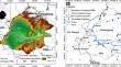
As an important large-scale commercial grain production base in China, the Songnen Plain has a particular need for groundwater resources. Here, the groundwater-storage (GWS) changes estimated by the Gravity Recovery and Climate Experiment (GRACE) and Global Land Data Assimilation System (GLDAS) data are input to the MIKE SHE model to correct the errors of remote sensing data. Through this, the simulation of groundwater levels at the large and medium regional scales (Songnen Plain) from 2005 to 2018 was achieved. The analysis reveals that the groundwater data derived from the estimation of GRACE and GLDAS data have a strong correlation with the measured data, with a correlation coefficient of 0.82 between GRACE and measured groundwater data and a correlation coefficient of –0.76 between GLDAS and measured groundwater data. In addition, estimated groundwater data were added to the MIKE SHE model to simulate Songnen Plain groundwater levels between 2005 and 2018. The simulation results indicate that the correlation between simulated and observed groundwater level data is substantially greater than that between inverted and observed groundwater data. Over the past 15 years, the Songnen Plain’s groundwater levels have exhibited a general upward trend of ~0.028 m/year. The groundwater levels in the northeastern, central, and western portions of the Songnen Plain are falling at a rate of ~0.144 m/year, while the groundwater levels in the southern and northwestern portions of the Songnen Plain and areas near the river are rising at a rate of ~0.513 m/year.
期刊介绍:
Hydrogeology Journal was founded in 1992 to foster understanding of hydrogeology; to describe worldwide progress in hydrogeology; and to provide an accessible forum for scientists, researchers, engineers, and practitioners in developing and industrialized countries.
Since then, the journal has earned a large worldwide readership. Its peer-reviewed research articles integrate subsurface hydrology and geology with supporting disciplines: geochemistry, geophysics, geomorphology, geobiology, surface-water hydrology, tectonics, numerical modeling, economics, and sociology.


 分享
分享
 求助内容:
求助内容: 应助结果提醒方式:
 扫码关注我们
