{"title":"Subsurface complexity controls the aquifer heterogeneity: A case study from the Al-Hassa oasis, Eastern Saudi Arabia","authors":"Abid Khogali , Konstantinos Chavanidis , Alexandros Stampolidis , Panagiotis Kirmizakis , Mohamed Yassin , Israa S. Abu-Mahfouz , Abdulaziz Al-Shaibani , Bassam Tawabini , Pantelis Soupios","doi":"10.1016/j.gsd.2024.101322","DOIUrl":null,"url":null,"abstract":"<div><p>Al-Hassa region in the eastern part of Saudi Arabia is well-known for its geological and hydrogeological importance since it has historically hosted over 280 natural springs, which were used to irrigate the largest oasis in the world. Al-Hassa is located near the renowned Ghawar oil field, the largest conventional oil field globally, which represents a potential pollution source. This study utilizes and integrate hydrochemical investigations and geophysical gravity surveys to understand and reconstruct the subsurface heterogeneity in the Al-Hassa area. The dataset encompasses 113 groundwater wells distributed across the Al-Hassa Oasis which have been analyzed for salinity major ions, and isotopic (oxygen and hydrogen) compositions. A total of 571 gravity stations covering the broader oasis area (approximately 350 km<sup>2</sup>) are collected, processed, and modeled. The combined hydrochemical and geophysical results show a good agreement between groundwater quality and density (gravity anomalies) distribution within the study area. The southeastern part of the study area exhibits distinctive positive gravity anomalies, indicating denser rock formations alongside high total dissolved solids (TDS) in groundwater, reflecting poor water quality. Conversely, the southwest displays significant negative gravity anomalies, suggesting basins filled with loose sediments and low TDS values, signifying good water quality. Furthermore, the study reveals a certain pattern in groundwater temperature distribution, with cooler waters in the areas characterized by negative gravity anomalies (basins), and hotter waters emerging from areas with positive gravity anomalies. These findings suggest that groundwater quality differences may stem from varying sub-basins and interactions with distinct geological substrates. Temperature variations may also be attributed to differing subsurface flow pathways. This study attempts to explain the controlling factors for groundwater heterogeneity in the Al-Hassa Oasis area, emphasizing the role of geological, tectonic, and hydrogeological elements in shaping the Oasis's hydrological and hydrochemical pattern.</p></div>","PeriodicalId":37879,"journal":{"name":"Groundwater for Sustainable Development","volume":"27 ","pages":"Article 101322"},"PeriodicalIF":4.9000,"publicationDate":"2024-11-01","publicationTypes":"Journal Article","fieldsOfStudy":null,"isOpenAccess":false,"openAccessPdf":"","citationCount":"0","resultStr":null,"platform":"Semanticscholar","paperid":null,"PeriodicalName":"Groundwater for Sustainable Development","FirstCategoryId":"1085","ListUrlMain":"https://www.sciencedirect.com/science/article/pii/S2352801X24002455","RegionNum":0,"RegionCategory":null,"ArticlePicture":[],"TitleCN":null,"AbstractTextCN":null,"PMCID":null,"EPubDate":"2024/8/20 0:00:00","PubModel":"Epub","JCR":"Q2","JCRName":"ENGINEERING, ENVIRONMENTAL","Score":null,"Total":0}
引用次数: 0
Abstract
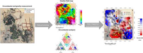
Al-Hassa region in the eastern part of Saudi Arabia is well-known for its geological and hydrogeological importance since it has historically hosted over 280 natural springs, which were used to irrigate the largest oasis in the world. Al-Hassa is located near the renowned Ghawar oil field, the largest conventional oil field globally, which represents a potential pollution source. This study utilizes and integrate hydrochemical investigations and geophysical gravity surveys to understand and reconstruct the subsurface heterogeneity in the Al-Hassa area. The dataset encompasses 113 groundwater wells distributed across the Al-Hassa Oasis which have been analyzed for salinity major ions, and isotopic (oxygen and hydrogen) compositions. A total of 571 gravity stations covering the broader oasis area (approximately 350 km2) are collected, processed, and modeled. The combined hydrochemical and geophysical results show a good agreement between groundwater quality and density (gravity anomalies) distribution within the study area. The southeastern part of the study area exhibits distinctive positive gravity anomalies, indicating denser rock formations alongside high total dissolved solids (TDS) in groundwater, reflecting poor water quality. Conversely, the southwest displays significant negative gravity anomalies, suggesting basins filled with loose sediments and low TDS values, signifying good water quality. Furthermore, the study reveals a certain pattern in groundwater temperature distribution, with cooler waters in the areas characterized by negative gravity anomalies (basins), and hotter waters emerging from areas with positive gravity anomalies. These findings suggest that groundwater quality differences may stem from varying sub-basins and interactions with distinct geological substrates. Temperature variations may also be attributed to differing subsurface flow pathways. This study attempts to explain the controlling factors for groundwater heterogeneity in the Al-Hassa Oasis area, emphasizing the role of geological, tectonic, and hydrogeological elements in shaping the Oasis's hydrological and hydrochemical pattern.
期刊介绍:
Groundwater for Sustainable Development is directed to different stakeholders and professionals, including government and non-governmental organizations, international funding agencies, universities, public water institutions, public health and other public/private sector professionals, and other relevant institutions. It is aimed at professionals, academics and students in the fields of disciplines such as: groundwater and its connection to surface hydrology and environment, soil sciences, engineering, ecology, microbiology, atmospheric sciences, analytical chemistry, hydro-engineering, water technology, environmental ethics, economics, public health, policy, as well as social sciences, legal disciplines, or any other area connected with water issues. The objectives of this journal are to facilitate: • The improvement of effective and sustainable management of water resources across the globe. • The improvement of human access to groundwater resources in adequate quantity and good quality. • The meeting of the increasing demand for drinking and irrigation water needed for food security to contribute to a social and economically sound human development. • The creation of a global inter- and multidisciplinary platform and forum to improve our understanding of groundwater resources and to advocate their effective and sustainable management and protection against contamination. • Interdisciplinary information exchange and to stimulate scientific research in the fields of groundwater related sciences and social and health sciences required to achieve the United Nations Millennium Development Goals for sustainable development.


 分享
分享
 求助内容:
求助内容: 应助结果提醒方式:
 扫码关注我们
