Yixin Zhang, Ningyuan Wang, Jie He, Tao Zhang, Xin Zhang, Hongpeng Luo
{"title":"A convenient archaeological ruins identification method through elevation information extraction from CORONA stereo pairs","authors":"Yixin Zhang, Ningyuan Wang, Jie He, Tao Zhang, Xin Zhang, Hongpeng Luo","doi":"10.1186/s40494-024-01427-7","DOIUrl":null,"url":null,"abstract":"<p>Three-dimensional (3-D) stereo images can be generated via computer-based image processing of CORONA stereo pairs. To a certain extent, important terrain and surface feature data extracted from these stereo images can improve the survey of archaeological sites and the identification and mapping of major landscapes. In this study, we focused on the identification of the archaeological ruins of Liangzhu City. An optical stereo model (red/blue stereo image) of the Liangzhu site was created through computer-based mosaicking and processing of CORONA remote-sensing stereo pairs taken in the 1960s and 1970s. By importing the optical stereo model into mobile phones, tablet computers, and other mobile devices, the research team undertook real-time locating of ruins via human observation, on-site investigation, and image overlay during a field survey and identified several Liangzhu-period dams, some of which have been confirmed via archaeological field investigations. The research team later applied the same method to the identification of tombs at the site of the mausoleums of the six emperors of the Southern Song dynasty. The results further prove that this method is feasible and reliable and can be widely promoted and used for the identification of archaeological ruins.</p>","PeriodicalId":13109,"journal":{"name":"Heritage Science","volume":"60 1","pages":""},"PeriodicalIF":3.9000,"publicationDate":"2024-09-06","publicationTypes":"Journal Article","fieldsOfStudy":null,"isOpenAccess":false,"openAccessPdf":"","citationCount":"0","resultStr":null,"platform":"Semanticscholar","paperid":null,"PeriodicalName":"Heritage Science","FirstCategoryId":"92","ListUrlMain":"https://doi.org/10.1186/s40494-024-01427-7","RegionNum":1,"RegionCategory":"艺术学","ArticlePicture":[],"TitleCN":null,"AbstractTextCN":null,"PMCID":null,"EPubDate":"","PubModel":"","JCR":"Q2","JCRName":"CHEMISTRY, ANALYTICAL","Score":null,"Total":0}
引用次数: 0
Abstract
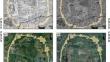
Three-dimensional (3-D) stereo images can be generated via computer-based image processing of CORONA stereo pairs. To a certain extent, important terrain and surface feature data extracted from these stereo images can improve the survey of archaeological sites and the identification and mapping of major landscapes. In this study, we focused on the identification of the archaeological ruins of Liangzhu City. An optical stereo model (red/blue stereo image) of the Liangzhu site was created through computer-based mosaicking and processing of CORONA remote-sensing stereo pairs taken in the 1960s and 1970s. By importing the optical stereo model into mobile phones, tablet computers, and other mobile devices, the research team undertook real-time locating of ruins via human observation, on-site investigation, and image overlay during a field survey and identified several Liangzhu-period dams, some of which have been confirmed via archaeological field investigations. The research team later applied the same method to the identification of tombs at the site of the mausoleums of the six emperors of the Southern Song dynasty. The results further prove that this method is feasible and reliable and can be widely promoted and used for the identification of archaeological ruins.
期刊介绍:
Heritage Science is an open access journal publishing original peer-reviewed research covering:
Understanding of the manufacturing processes, provenances, and environmental contexts of material types, objects, and buildings, of cultural significance including their historical significance.
Understanding and prediction of physico-chemical and biological degradation processes of cultural artefacts, including climate change, and predictive heritage studies.
Development and application of analytical and imaging methods or equipments for non-invasive, non-destructive or portable analysis of artwork and objects of cultural significance to identify component materials, degradation products and deterioration markers.
Development and application of invasive and destructive methods for understanding the provenance of objects of cultural significance.
Development and critical assessment of treatment materials and methods for artwork and objects of cultural significance.
Development and application of statistical methods and algorithms for data analysis to further understanding of culturally significant objects.
Publication of reference and corpus datasets as supplementary information to the statistical and analytical studies above.
Description of novel technologies that can assist in the understanding of cultural heritage.


 分享
分享
 求助内容:
求助内容: 应助结果提醒方式:
 扫码关注我们
