Exploring Topography Downscaling Methods for Hyper-Resolution Land Surface Modeling

IF 3.8 2区 地球科学 Q2 METEOROLOGY & ATMOSPHERIC SCIENCES Journal of Geophysical Research: Atmospheres Pub Date : 2024-10-22 DOI:10.1029/2024JD041338
Sisi Chen, Lu Li, Zhongwang Wei, Nan Wei, Yonggen Zhang, Shupeng Zhang, Hua Yuan, Wei Shangguan, Shulei Zhang, Qingliang Li, Yongjiu Dai
{"title":"Exploring Topography Downscaling Methods for Hyper-Resolution Land Surface Modeling","authors":"Sisi Chen,&nbsp;Lu Li,&nbsp;Zhongwang Wei,&nbsp;Nan Wei,&nbsp;Yonggen Zhang,&nbsp;Shupeng Zhang,&nbsp;Hua Yuan,&nbsp;Wei Shangguan,&nbsp;Shulei Zhang,&nbsp;Qingliang Li,&nbsp;Yongjiu Dai","doi":"10.1029/2024JD041338","DOIUrl":null,"url":null,"abstract":"<div>\n \n \n <section>\n \n <p>Hyper-resolution land surface modeling provides an unprecedented opportunity to simulate locally relevant water and energy cycles. However, the available meteorological forcing data is often insufficient to fulfill the requirements of hyper-resolution modeling. Here, we developed a comprehensive downscaling framework based on topography-adjusted methods and automated machine learning (AutoML). With this framework, a 90 m and hourly atmospheric forcing data set was developed from ERA5 data at a 0.25° resolution, and the Common Land Model (CoLM) was then forced with the developed forcing data over two complex terrain regions (the Heihe River Basin and Upper Colorado River Basin). We systematically evaluated the downscaled forcing and the CoLM outputs against both in situ observations and gridded data. The ground-based validation results suggested consistent improvements for all downscaled forcing variables with mean RMSE improved by 6.362%–95.86%. The downscaled forcings, which incorporated detailed topographic features, offered improved magnitude estimates, achieving a comparable level of performance to that of regional reanalysis forcing data. The downscaled forcing driving the CoLM model showed comparable or better skills in simulating water and energy fluxes, as verified by in situ validations. The hyper-resolution simulations provided a detailed and more reasonable description of land surface processes and attained similar spatial patterns and magnitudes with high-resolution land surface data, especially over highly elevated areas. Additionally, this study highlighted the benefits of using mountain radiation theory-based shortwave radiation downscaling models and AutoML-assisted precipitation downscaling models. These findings emphasized the significance of integrating topography-based downscaling methods for hillslope-scale simulations.</p>\n </section>\n </div>","PeriodicalId":15986,"journal":{"name":"Journal of Geophysical Research: Atmospheres","volume":"129 20","pages":""},"PeriodicalIF":3.8000,"publicationDate":"2024-10-22","publicationTypes":"Journal Article","fieldsOfStudy":null,"isOpenAccess":false,"openAccessPdf":"https://onlinelibrary.wiley.com/doi/epdf/10.1029/2024JD041338","citationCount":"0","resultStr":null,"platform":"Semanticscholar","paperid":null,"PeriodicalName":"Journal of Geophysical Research: Atmospheres","FirstCategoryId":"89","ListUrlMain":"https://onlinelibrary.wiley.com/doi/10.1029/2024JD041338","RegionNum":2,"RegionCategory":"地球科学","ArticlePicture":[],"TitleCN":null,"AbstractTextCN":null,"PMCID":null,"EPubDate":"","PubModel":"","JCR":"Q2","JCRName":"METEOROLOGY & ATMOSPHERIC SCIENCES","Score":null,"Total":0}
引用次数: 0

Abstract

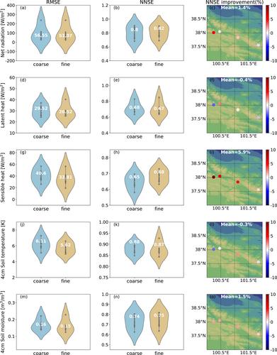
Hyper-resolution land surface modeling provides an unprecedented opportunity to simulate locally relevant water and energy cycles. However, the available meteorological forcing data is often insufficient to fulfill the requirements of hyper-resolution modeling. Here, we developed a comprehensive downscaling framework based on topography-adjusted methods and automated machine learning (AutoML). With this framework, a 90 m and hourly atmospheric forcing data set was developed from ERA5 data at a 0.25° resolution, and the Common Land Model (CoLM) was then forced with the developed forcing data over two complex terrain regions (the Heihe River Basin and Upper Colorado River Basin). We systematically evaluated the downscaled forcing and the CoLM outputs against both in situ observations and gridded data. The ground-based validation results suggested consistent improvements for all downscaled forcing variables with mean RMSE improved by 6.362%–95.86%. The downscaled forcings, which incorporated detailed topographic features, offered improved magnitude estimates, achieving a comparable level of performance to that of regional reanalysis forcing data. The downscaled forcing driving the CoLM model showed comparable or better skills in simulating water and energy fluxes, as verified by in situ validations. The hyper-resolution simulations provided a detailed and more reasonable description of land surface processes and attained similar spatial patterns and magnitudes with high-resolution land surface data, especially over highly elevated areas. Additionally, this study highlighted the benefits of using mountain radiation theory-based shortwave radiation downscaling models and AutoML-assisted precipitation downscaling models. These findings emphasized the significance of integrating topography-based downscaling methods for hillslope-scale simulations.
Abstract Image

查看原文
分享 分享
微信好友 朋友圈 QQ好友 复制链接
本刊更多论文
探索用于超分辨率地表建模的地形降尺度方法
超分辨率地表建模为模拟与当地相关的水循环和能量循环提供了前所未有的机会。然而,现有的气象强迫数据往往不足以满足超分辨率建模的要求。在此,我们开发了一个基于地形调整方法和自动机器学习(AutoML)的综合降尺度框架。利用该框架,我们从分辨率为 0.25°的ERA5 数据中开发了 90 米和每小时大气强迫数据集,然后利用开发的强迫数据对两个复杂地形区(黑河流域和科罗拉多河上游流域)的共同陆地模式(CoLM)进行了强迫。我们对照原地观测数据和网格数据,系统地评估了降尺度强迫和 CoLM 输出结果。地面验证结果表明,所有降尺度强迫变量都得到了一致的改善,平均均方根误差(RMSE)改善了 6.362%-95.86%。包含详细地形特征的降尺度作用力提供了更好的幅值估计,达到了与区域再分析作用力数据相当的性能水平。经现场验证,CoLM 模型的降尺度强迫在模拟水和能量通量方面表现出相当或更好的能力。超分辨率模拟对陆地表面过程进行了更详细、更合理的描述,并获得了与高分辨率陆地表面数据相似的空间模式和幅度,尤其是在高海拔地区。此外,这项研究还强调了使用基于山地辐射理论的短波辐射降尺度模型和 AutoML 辅助降水降尺度模型的好处。这些发现强调了在山坡尺度模拟中整合基于地形的降尺度方法的重要性。
本文章由计算机程序翻译,如有差异,请以英文原文为准。
求助全文
约1分钟内获得全文 去求助
来源期刊
Journal of Geophysical Research: Atmospheres
Journal of Geophysical Research: Atmospheres Earth and Planetary Sciences-Geophysics
CiteScore
7.30
自引率
11.40%
发文量
684
期刊介绍: JGR: Atmospheres publishes articles that advance and improve understanding of atmospheric properties and processes, including the interaction of the atmosphere with other components of the Earth system.
期刊最新文献
Analysis of the Influence of Clear-Sky Fluxes on the Cloud-Type Mean Cloud Radiative Effects in the Tropical Convectively Active Regions With CERES Satellite Data A Simple Model for the Evaporation of Hydrometeors and Their Isotopes Modeling the Effects of Vegetation and Snow on Dust Storm Over the Gobi Desert Origins of Extreme CAPE Around the World A More Transparent Infrared Window
×
引用
GB/T 7714-2015
复制
MLA
复制
APA
复制
导出至
BibTeX EndNote RefMan NoteFirst NoteExpress
×
×
提示
您的信息不完整,为了账户安全,请先补充。
现在去补充
×
提示
您因"违规操作"
具体请查看互助需知
我知道了
×
提示
现在去查看 取消
×
提示
确定
0
微信
客服QQ
Book学术公众号 扫码关注我们
反馈
×
意见反馈
请填写您的意见或建议
请填写您的手机或邮箱
已复制链接
已复制链接
快去分享给好友吧!
我知道了
×
扫码分享
扫码分享
Book学术官方微信
Book学术文献互助
Book学术文献互助群
群 号:481959085
Book学术
文献互助 智能选刊 最新文献 互助须知 联系我们:info@booksci.cn
Book学术提供免费学术资源搜索服务,方便国内外学者检索中英文文献。致力于提供最便捷和优质的服务体验。
Copyright © 2023 Book学术 All rights reserved.
ghs 京公网安备 11010802042870号 京ICP备2023020795号-1