Michael Attia, Frank T.-C. Tsai, Shuo Yang, Burke Minsley, Wade H. Kress
{"title":"Airborne Geophysical Analysis to Decipher Salinization for Coastal Louisiana","authors":"Michael Attia, Frank T.-C. Tsai, Shuo Yang, Burke Minsley, Wade H. Kress","doi":"10.1016/j.watres.2025.123215","DOIUrl":null,"url":null,"abstract":"Coastal Louisiana is known for saltwater intrusion that threatens wetlands, aquifers, and rivers. However, the extent of saltwater intrusion is not well understood. This study develops an innovative framework with airborne electromagnetic (AEM) data to map chloride concentration distributions for wetlands in the Mississippi River deltaic plain and Chenier plain as well as for the Mississippi River Valley alluvial aquifer (MRVA) and Chicot aquifer. Moreover, the framework maps chloride concentrations along the Mississippi River and Atchafalaya River. Key components in the framework include the establishment of resistivity-to-chloride concentration transformation, 3D resistivity architecture building through geostatistics, and the employment of a lithologic model. The transformation functions correlate AEM resistivity data with porewater salinity measurements and groundwater and river chloride samples. The results show that AEM data reliably infers soil water chloride concentrations and correlates well with the distribution of various marsh types. AEM data reveals extensive saltwater presence at depth and near the coast, originating from salt domes and the Gulf of Mexico, respectively. The saltwater upconing pattern in the Chicot aquifer is likely due to excessive groundwater withdrawals. The AEM data also confirms a distinct tongue of saltwater intruding into the Atchafalaya Basin from the Gulf. The AEM data helps to identify faults that are obscured or eroded at the surface, which appear as leaky barriers in the subsurface where dramatic changes in chloride concentration are apparent. Finally, this study uses the AEM data to infer the presence of an extensive seawater wedge in the Mississippi River and Atchafalaya River.","PeriodicalId":443,"journal":{"name":"Water Research","volume":"91 1","pages":""},"PeriodicalIF":11.4000,"publicationDate":"2025-01-28","publicationTypes":"Journal Article","fieldsOfStudy":null,"isOpenAccess":false,"openAccessPdf":"","citationCount":"0","resultStr":null,"platform":"Semanticscholar","paperid":null,"PeriodicalName":"Water Research","FirstCategoryId":"93","ListUrlMain":"https://doi.org/10.1016/j.watres.2025.123215","RegionNum":1,"RegionCategory":"环境科学与生态学","ArticlePicture":[],"TitleCN":null,"AbstractTextCN":null,"PMCID":null,"EPubDate":"","PubModel":"","JCR":"Q1","JCRName":"ENGINEERING, ENVIRONMENTAL","Score":null,"Total":0}
引用次数: 0
Abstract
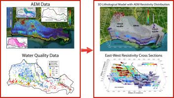
Coastal Louisiana is known for saltwater intrusion that threatens wetlands, aquifers, and rivers. However, the extent of saltwater intrusion is not well understood. This study develops an innovative framework with airborne electromagnetic (AEM) data to map chloride concentration distributions for wetlands in the Mississippi River deltaic plain and Chenier plain as well as for the Mississippi River Valley alluvial aquifer (MRVA) and Chicot aquifer. Moreover, the framework maps chloride concentrations along the Mississippi River and Atchafalaya River. Key components in the framework include the establishment of resistivity-to-chloride concentration transformation, 3D resistivity architecture building through geostatistics, and the employment of a lithologic model. The transformation functions correlate AEM resistivity data with porewater salinity measurements and groundwater and river chloride samples. The results show that AEM data reliably infers soil water chloride concentrations and correlates well with the distribution of various marsh types. AEM data reveals extensive saltwater presence at depth and near the coast, originating from salt domes and the Gulf of Mexico, respectively. The saltwater upconing pattern in the Chicot aquifer is likely due to excessive groundwater withdrawals. The AEM data also confirms a distinct tongue of saltwater intruding into the Atchafalaya Basin from the Gulf. The AEM data helps to identify faults that are obscured or eroded at the surface, which appear as leaky barriers in the subsurface where dramatic changes in chloride concentration are apparent. Finally, this study uses the AEM data to infer the presence of an extensive seawater wedge in the Mississippi River and Atchafalaya River.
期刊介绍:
Water Research, along with its open access companion journal Water Research X, serves as a platform for publishing original research papers covering various aspects of the science and technology related to the anthropogenic water cycle, water quality, and its management worldwide. The audience targeted by the journal comprises biologists, chemical engineers, chemists, civil engineers, environmental engineers, limnologists, and microbiologists. The scope of the journal include:
•Treatment processes for water and wastewaters (municipal, agricultural, industrial, and on-site treatment), including resource recovery and residuals management;
•Urban hydrology including sewer systems, stormwater management, and green infrastructure;
•Drinking water treatment and distribution;
•Potable and non-potable water reuse;
•Sanitation, public health, and risk assessment;
•Anaerobic digestion, solid and hazardous waste management, including source characterization and the effects and control of leachates and gaseous emissions;
•Contaminants (chemical, microbial, anthropogenic particles such as nanoparticles or microplastics) and related water quality sensing, monitoring, fate, and assessment;
•Anthropogenic impacts on inland, tidal, coastal and urban waters, focusing on surface and ground waters, and point and non-point sources of pollution;
•Environmental restoration, linked to surface water, groundwater and groundwater remediation;
•Analysis of the interfaces between sediments and water, and between water and atmosphere, focusing specifically on anthropogenic impacts;
•Mathematical modelling, systems analysis, machine learning, and beneficial use of big data related to the anthropogenic water cycle;
•Socio-economic, policy, and regulations studies.


 分享
分享
 求助内容:
求助内容: 应助结果提醒方式:
 扫码关注我们
