Yunfei Du , Xiangju Han , Ya Ping Wang , Daidu Fan , Jicai Zhang
{"title":"Multiscale spatio‐temporal variability of suspended sediment front in the Yangtze River Estuary and its ecological effects","authors":"Yunfei Du , Xiangju Han , Ya Ping Wang , Daidu Fan , Jicai Zhang","doi":"10.1016/j.watres.2025.123349","DOIUrl":null,"url":null,"abstract":"<div><div>The suspended sediment front (SSF) in the Yangtze River Estuary significantly affects regional circulation, water quality, and productivity. However, the quantitative understanding of its multiscale spatio‐temporal variations and associated ecological effects remains largely limited. Utilizing suspended sediment concentration remote sensing data from 2012 to 2018, we applied an improved gradient-based front detection algorithm to identify SSFs. Our analysis highlighted significant variability in the SSF and established its oscillating boundaries. The mean longitude location of the front is approximately 122.2°E, extending up to 122.8°E, with its occurrence frequency negatively correlated with water depth. The control effect of estuarine engineering projects on lateral sediment exchange results in the more frequent occurrence of stable banded fronts in these areas. The SSF exhibits notable spatial pattern variability and fluctuations on tidal to interannual scales. Compared to other tidal types, the front extends furthest offshore during spring tides due to enhanced tidal mixing and seaward residual flow. The seasonal variations in the frontal location are closely related to ocean dynamic processes, jointly controlled by the mixed layer depth, wind speed, wind direction, wave intensity, and sea surface temperature. The direct influence of sediment load from the Yangtze River is most pronounced in July, coinciding with peak sediment load. The interannual variations indicate a strong correlation between frontal migration and sediment load. Meanwhile, extreme storm events cause significant resuspension of bed sediments, resulting in substantial offshore movement of the SSF (>14 km), with effects persisting for at least 2 days. Major floods modulate the short-term fluctuation range of the front by significantly increasing the sediment transport flux. Further investigation into the ecological effects of the SSF reveals that in summer, the dual front system comprising the SSF and plume front strongly controls estuarine primary productivity, with regions of high chlorophyll-a concentration aligning well with the seaward oscillation boundary of the SSF. Temperature, salinity, and nutrient concentration near the SSF also exhibit drastic changes. Conversely, in winter, insufficient runoff results in a single SSF system, leading to suboptimal nutrient, temperature, and light conditions, and consequently, very low primary productivity.</div></div>","PeriodicalId":443,"journal":{"name":"Water Research","volume":"279 ","pages":"Article 123349"},"PeriodicalIF":12.4000,"publicationDate":"2025-02-21","publicationTypes":"Journal Article","fieldsOfStudy":null,"isOpenAccess":false,"openAccessPdf":"","citationCount":"0","resultStr":null,"platform":"Semanticscholar","paperid":null,"PeriodicalName":"Water Research","FirstCategoryId":"93","ListUrlMain":"https://www.sciencedirect.com/science/article/pii/S0043135425002623","RegionNum":1,"RegionCategory":"环境科学与生态学","ArticlePicture":[],"TitleCN":null,"AbstractTextCN":null,"PMCID":null,"EPubDate":"","PubModel":"","JCR":"Q1","JCRName":"ENGINEERING, ENVIRONMENTAL","Score":null,"Total":0}
引用次数: 0
Abstract
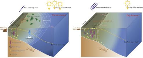
The suspended sediment front (SSF) in the Yangtze River Estuary significantly affects regional circulation, water quality, and productivity. However, the quantitative understanding of its multiscale spatio‐temporal variations and associated ecological effects remains largely limited. Utilizing suspended sediment concentration remote sensing data from 2012 to 2018, we applied an improved gradient-based front detection algorithm to identify SSFs. Our analysis highlighted significant variability in the SSF and established its oscillating boundaries. The mean longitude location of the front is approximately 122.2°E, extending up to 122.8°E, with its occurrence frequency negatively correlated with water depth. The control effect of estuarine engineering projects on lateral sediment exchange results in the more frequent occurrence of stable banded fronts in these areas. The SSF exhibits notable spatial pattern variability and fluctuations on tidal to interannual scales. Compared to other tidal types, the front extends furthest offshore during spring tides due to enhanced tidal mixing and seaward residual flow. The seasonal variations in the frontal location are closely related to ocean dynamic processes, jointly controlled by the mixed layer depth, wind speed, wind direction, wave intensity, and sea surface temperature. The direct influence of sediment load from the Yangtze River is most pronounced in July, coinciding with peak sediment load. The interannual variations indicate a strong correlation between frontal migration and sediment load. Meanwhile, extreme storm events cause significant resuspension of bed sediments, resulting in substantial offshore movement of the SSF (>14 km), with effects persisting for at least 2 days. Major floods modulate the short-term fluctuation range of the front by significantly increasing the sediment transport flux. Further investigation into the ecological effects of the SSF reveals that in summer, the dual front system comprising the SSF and plume front strongly controls estuarine primary productivity, with regions of high chlorophyll-a concentration aligning well with the seaward oscillation boundary of the SSF. Temperature, salinity, and nutrient concentration near the SSF also exhibit drastic changes. Conversely, in winter, insufficient runoff results in a single SSF system, leading to suboptimal nutrient, temperature, and light conditions, and consequently, very low primary productivity.
期刊介绍:
Water Research, along with its open access companion journal Water Research X, serves as a platform for publishing original research papers covering various aspects of the science and technology related to the anthropogenic water cycle, water quality, and its management worldwide. The audience targeted by the journal comprises biologists, chemical engineers, chemists, civil engineers, environmental engineers, limnologists, and microbiologists. The scope of the journal include:
•Treatment processes for water and wastewaters (municipal, agricultural, industrial, and on-site treatment), including resource recovery and residuals management;
•Urban hydrology including sewer systems, stormwater management, and green infrastructure;
•Drinking water treatment and distribution;
•Potable and non-potable water reuse;
•Sanitation, public health, and risk assessment;
•Anaerobic digestion, solid and hazardous waste management, including source characterization and the effects and control of leachates and gaseous emissions;
•Contaminants (chemical, microbial, anthropogenic particles such as nanoparticles or microplastics) and related water quality sensing, monitoring, fate, and assessment;
•Anthropogenic impacts on inland, tidal, coastal and urban waters, focusing on surface and ground waters, and point and non-point sources of pollution;
•Environmental restoration, linked to surface water, groundwater and groundwater remediation;
•Analysis of the interfaces between sediments and water, and between water and atmosphere, focusing specifically on anthropogenic impacts;
•Mathematical modelling, systems analysis, machine learning, and beneficial use of big data related to the anthropogenic water cycle;
•Socio-economic, policy, and regulations studies.


 分享
分享
 求助内容:
求助内容: 应助结果提醒方式:
 扫码关注我们
