{"title":"亚利桑那地下水勘探:交互式地图评估历史和当前的地下水条件在美国亚利桑那州的井","authors":"Fred D Tillman, Marilyn E. Flynn","doi":"10.1007/s10040-023-02748-w","DOIUrl":null,"url":null,"abstract":"<p>Groundwater is an important water source in Arizona, accounting for about 41% of water use in this mostly arid-to-semiarid state in the southwestern United States, and the availability of groundwater resources in the state is a concern. To provide accessible information from depth-to-groundwater data, a series of web-based interactive maps were developed, called the Arizona Groundwater Explorer (AGEx). Scripts were written to harmonize and synthesize groundwater datasets from the two largest publicly available sources, subset these data to address different groundwater availability questions, and display the results in online, interactive maps. The combined dataset contained 1,820,122 depth-to-groundwater measurements from 1891 through 2022 from 41,918 wells in Arizona. Data views are provided for 20 topics, including recent (2020 or later) depth to groundwater (4,569 wells), historical (pre-1950) depth to groundwater (4,287 wells), wells with long-term (≥50 years) records (1,183 wells), wells with recent groundwater level decline (277 wells), wells with recent groundwater level rise (120 wells), and linear trends in groundwater levels over ten 10-year periods (number of wells ranging from 341 in 1978–1987 to 1,208 in 2003–2012), among others. With ongoing drought in the region resulting in declining surface-water supplies in Arizona, groundwater may play an even larger role in satisfying water needs in the state. The AGEx series of maps provides a nonspecialist audience with an improved understanding of historical, current, and changes in groundwater levels in Arizona.</p>","PeriodicalId":13013,"journal":{"name":"Hydrogeology Journal","volume":"64 1","pages":""},"PeriodicalIF":2.4000,"publicationDate":"2023-11-22","publicationTypes":"Journal Article","fieldsOfStudy":null,"isOpenAccess":false,"openAccessPdf":"","citationCount":"0","resultStr":"{\"title\":\"Arizona Groundwater Explorer: interactive maps for evaluating the historical and current groundwater conditions in wells in Arizona, USA\",\"authors\":\"Fred D Tillman, Marilyn E. Flynn\",\"doi\":\"10.1007/s10040-023-02748-w\",\"DOIUrl\":null,\"url\":null,\"abstract\":\"<p>Groundwater is an important water source in Arizona, accounting for about 41% of water use in this mostly arid-to-semiarid state in the southwestern United States, and the availability of groundwater resources in the state is a concern. To provide accessible information from depth-to-groundwater data, a series of web-based interactive maps were developed, called the Arizona Groundwater Explorer (AGEx). Scripts were written to harmonize and synthesize groundwater datasets from the two largest publicly available sources, subset these data to address different groundwater availability questions, and display the results in online, interactive maps. The combined dataset contained 1,820,122 depth-to-groundwater measurements from 1891 through 2022 from 41,918 wells in Arizona. Data views are provided for 20 topics, including recent (2020 or later) depth to groundwater (4,569 wells), historical (pre-1950) depth to groundwater (4,287 wells), wells with long-term (≥50 years) records (1,183 wells), wells with recent groundwater level decline (277 wells), wells with recent groundwater level rise (120 wells), and linear trends in groundwater levels over ten 10-year periods (number of wells ranging from 341 in 1978–1987 to 1,208 in 2003–2012), among others. With ongoing drought in the region resulting in declining surface-water supplies in Arizona, groundwater may play an even larger role in satisfying water needs in the state. The AGEx series of maps provides a nonspecialist audience with an improved understanding of historical, current, and changes in groundwater levels in Arizona.</p>\",\"PeriodicalId\":13013,\"journal\":{\"name\":\"Hydrogeology Journal\",\"volume\":\"64 1\",\"pages\":\"\"},\"PeriodicalIF\":2.4000,\"publicationDate\":\"2023-11-22\",\"publicationTypes\":\"Journal Article\",\"fieldsOfStudy\":null,\"isOpenAccess\":false,\"openAccessPdf\":\"\",\"citationCount\":\"0\",\"resultStr\":null,\"platform\":\"Semanticscholar\",\"paperid\":null,\"PeriodicalName\":\"Hydrogeology Journal\",\"FirstCategoryId\":\"89\",\"ListUrlMain\":\"https://doi.org/10.1007/s10040-023-02748-w\",\"RegionNum\":3,\"RegionCategory\":\"地球科学\",\"ArticlePicture\":[],\"TitleCN\":null,\"AbstractTextCN\":null,\"PMCID\":null,\"EPubDate\":\"\",\"PubModel\":\"\",\"JCR\":\"Q2\",\"JCRName\":\"GEOSCIENCES, MULTIDISCIPLINARY\",\"Score\":null,\"Total\":0}","platform":"Semanticscholar","paperid":null,"PeriodicalName":"Hydrogeology Journal","FirstCategoryId":"89","ListUrlMain":"https://doi.org/10.1007/s10040-023-02748-w","RegionNum":3,"RegionCategory":"地球科学","ArticlePicture":[],"TitleCN":null,"AbstractTextCN":null,"PMCID":null,"EPubDate":"","PubModel":"","JCR":"Q2","JCRName":"GEOSCIENCES, MULTIDISCIPLINARY","Score":null,"Total":0}
Arizona Groundwater Explorer: interactive maps for evaluating the historical and current groundwater conditions in wells in Arizona, USA
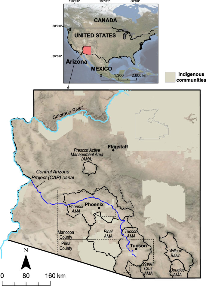
Groundwater is an important water source in Arizona, accounting for about 41% of water use in this mostly arid-to-semiarid state in the southwestern United States, and the availability of groundwater resources in the state is a concern. To provide accessible information from depth-to-groundwater data, a series of web-based interactive maps were developed, called the Arizona Groundwater Explorer (AGEx). Scripts were written to harmonize and synthesize groundwater datasets from the two largest publicly available sources, subset these data to address different groundwater availability questions, and display the results in online, interactive maps. The combined dataset contained 1,820,122 depth-to-groundwater measurements from 1891 through 2022 from 41,918 wells in Arizona. Data views are provided for 20 topics, including recent (2020 or later) depth to groundwater (4,569 wells), historical (pre-1950) depth to groundwater (4,287 wells), wells with long-term (≥50 years) records (1,183 wells), wells with recent groundwater level decline (277 wells), wells with recent groundwater level rise (120 wells), and linear trends in groundwater levels over ten 10-year periods (number of wells ranging from 341 in 1978–1987 to 1,208 in 2003–2012), among others. With ongoing drought in the region resulting in declining surface-water supplies in Arizona, groundwater may play an even larger role in satisfying water needs in the state. The AGEx series of maps provides a nonspecialist audience with an improved understanding of historical, current, and changes in groundwater levels in Arizona.
期刊介绍:
Hydrogeology Journal was founded in 1992 to foster understanding of hydrogeology; to describe worldwide progress in hydrogeology; and to provide an accessible forum for scientists, researchers, engineers, and practitioners in developing and industrialized countries.
Since then, the journal has earned a large worldwide readership. Its peer-reviewed research articles integrate subsurface hydrology and geology with supporting disciplines: geochemistry, geophysics, geomorphology, geobiology, surface-water hydrology, tectonics, numerical modeling, economics, and sociology.


 分享
分享
 求助内容:
求助内容: 应助结果提醒方式:
 扫码关注我们
