Marjorie Beate Kreis, Jean-Denis Taupin, Patrick Lachassagne, Nicolas Patris, Eduardo Sávio Passos Rodrigues Martins
{"title":"造成巴西半干旱地区地下水盐碱化的结晶非承压含水层蒸腾作用","authors":"Marjorie Beate Kreis, Jean-Denis Taupin, Patrick Lachassagne, Nicolas Patris, Eduardo Sávio Passos Rodrigues Martins","doi":"10.1007/s10040-023-02755-x","DOIUrl":null,"url":null,"abstract":"<p>The high groundwater salinity of crystalline aquifers in semiarid areas is generally attributed to the dissolution and leaching of meteoric salts that have been progressively evapoconcentrated in the different hydrological compartments under dry climate conditions. A numerical model, simulating water and salt balances, was developed from a case study in Northeast Brazil to: (1) test the validity of this hypothesis, through the quantification of all relevant water cycle processes in the studied watershed, and (2) demonstrate how changes in land cover can impact groundwater salinity. Computations showed that the aridity and the high evapo(transpi)ration rates from the unsaturated zone and/or surface water (ponds, reservoirs) cannot lead to the observed aquifer salinization levels, but only to concentrations of a few tens or hundreds of mg L<sup>–1</sup> (Cl<sup>–</sup>). The only process that can induce a high groundwater salinity, with chloride concentrations up to several g L<sup>–1</sup>, is the transpiration of groundwater by the deep roots of the vegetation, with a rate reaching 100% of the annual recharge. In this case study, the vegetation involved is the native Caatinga forest. Simulations of the long-term dynamics of groundwater salinity indicate that aquifer areas with high salinity are relicts of the Caatinga pre-colonization period during which subterranean endorheic conditions were prevailing. Following the Caatinga deforestation linked to colonial agricultural development, aquifer recharge increased and endorheism ceased. Consequently, these aquifers may have now been experiencing a desalination process for about three centuries. The desalination spatial variability drivers are explained in the paper.</p>","PeriodicalId":13013,"journal":{"name":"Hydrogeology Journal","volume":"10 1","pages":""},"PeriodicalIF":2.3000,"publicationDate":"2023-12-13","publicationTypes":"Journal Article","fieldsOfStudy":null,"isOpenAccess":false,"openAccessPdf":"","citationCount":"0","resultStr":"{\"title\":\"Transpiration from crystalline unconfined aquifers as the cause of groundwater salinization in a semiarid area of Brazil\",\"authors\":\"Marjorie Beate Kreis, Jean-Denis Taupin, Patrick Lachassagne, Nicolas Patris, Eduardo Sávio Passos Rodrigues Martins\",\"doi\":\"10.1007/s10040-023-02755-x\",\"DOIUrl\":null,\"url\":null,\"abstract\":\"<p>The high groundwater salinity of crystalline aquifers in semiarid areas is generally attributed to the dissolution and leaching of meteoric salts that have been progressively evapoconcentrated in the different hydrological compartments under dry climate conditions. A numerical model, simulating water and salt balances, was developed from a case study in Northeast Brazil to: (1) test the validity of this hypothesis, through the quantification of all relevant water cycle processes in the studied watershed, and (2) demonstrate how changes in land cover can impact groundwater salinity. Computations showed that the aridity and the high evapo(transpi)ration rates from the unsaturated zone and/or surface water (ponds, reservoirs) cannot lead to the observed aquifer salinization levels, but only to concentrations of a few tens or hundreds of mg L<sup>–1</sup> (Cl<sup>–</sup>). The only process that can induce a high groundwater salinity, with chloride concentrations up to several g L<sup>–1</sup>, is the transpiration of groundwater by the deep roots of the vegetation, with a rate reaching 100% of the annual recharge. In this case study, the vegetation involved is the native Caatinga forest. Simulations of the long-term dynamics of groundwater salinity indicate that aquifer areas with high salinity are relicts of the Caatinga pre-colonization period during which subterranean endorheic conditions were prevailing. Following the Caatinga deforestation linked to colonial agricultural development, aquifer recharge increased and endorheism ceased. Consequently, these aquifers may have now been experiencing a desalination process for about three centuries. The desalination spatial variability drivers are explained in the paper.</p>\",\"PeriodicalId\":13013,\"journal\":{\"name\":\"Hydrogeology Journal\",\"volume\":\"10 1\",\"pages\":\"\"},\"PeriodicalIF\":2.3000,\"publicationDate\":\"2023-12-13\",\"publicationTypes\":\"Journal Article\",\"fieldsOfStudy\":null,\"isOpenAccess\":false,\"openAccessPdf\":\"\",\"citationCount\":\"0\",\"resultStr\":null,\"platform\":\"Semanticscholar\",\"paperid\":null,\"PeriodicalName\":\"Hydrogeology Journal\",\"FirstCategoryId\":\"89\",\"ListUrlMain\":\"https://doi.org/10.1007/s10040-023-02755-x\",\"RegionNum\":3,\"RegionCategory\":\"地球科学\",\"ArticlePicture\":[],\"TitleCN\":null,\"AbstractTextCN\":null,\"PMCID\":null,\"EPubDate\":\"\",\"PubModel\":\"\",\"JCR\":\"Q2\",\"JCRName\":\"GEOSCIENCES, MULTIDISCIPLINARY\",\"Score\":null,\"Total\":0}","platform":"Semanticscholar","paperid":null,"PeriodicalName":"Hydrogeology Journal","FirstCategoryId":"89","ListUrlMain":"https://doi.org/10.1007/s10040-023-02755-x","RegionNum":3,"RegionCategory":"地球科学","ArticlePicture":[],"TitleCN":null,"AbstractTextCN":null,"PMCID":null,"EPubDate":"","PubModel":"","JCR":"Q2","JCRName":"GEOSCIENCES, MULTIDISCIPLINARY","Score":null,"Total":0}
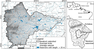
Transpiration from crystalline unconfined aquifers as the cause of groundwater salinization in a semiarid area of Brazil
The high groundwater salinity of crystalline aquifers in semiarid areas is generally attributed to the dissolution and leaching of meteoric salts that have been progressively evapoconcentrated in the different hydrological compartments under dry climate conditions. A numerical model, simulating water and salt balances, was developed from a case study in Northeast Brazil to: (1) test the validity of this hypothesis, through the quantification of all relevant water cycle processes in the studied watershed, and (2) demonstrate how changes in land cover can impact groundwater salinity. Computations showed that the aridity and the high evapo(transpi)ration rates from the unsaturated zone and/or surface water (ponds, reservoirs) cannot lead to the observed aquifer salinization levels, but only to concentrations of a few tens or hundreds of mg L–1 (Cl–). The only process that can induce a high groundwater salinity, with chloride concentrations up to several g L–1, is the transpiration of groundwater by the deep roots of the vegetation, with a rate reaching 100% of the annual recharge. In this case study, the vegetation involved is the native Caatinga forest. Simulations of the long-term dynamics of groundwater salinity indicate that aquifer areas with high salinity are relicts of the Caatinga pre-colonization period during which subterranean endorheic conditions were prevailing. Following the Caatinga deforestation linked to colonial agricultural development, aquifer recharge increased and endorheism ceased. Consequently, these aquifers may have now been experiencing a desalination process for about three centuries. The desalination spatial variability drivers are explained in the paper.
期刊介绍:
Hydrogeology Journal was founded in 1992 to foster understanding of hydrogeology; to describe worldwide progress in hydrogeology; and to provide an accessible forum for scientists, researchers, engineers, and practitioners in developing and industrialized countries.
Since then, the journal has earned a large worldwide readership. Its peer-reviewed research articles integrate subsurface hydrology and geology with supporting disciplines: geochemistry, geophysics, geomorphology, geobiology, surface-water hydrology, tectonics, numerical modeling, economics, and sociology.


 分享
分享
 求助内容:
求助内容: 应助结果提醒方式:
 扫码关注我们
