Dejun Teng, Furqan Baig, Zhaohui Peng, Jun Kong, Fusheng Wang
{"title":"使用混合表示法对复杂多边形进行高效空间查询","authors":"Dejun Teng, Furqan Baig, Zhaohui Peng, Jun Kong, Fusheng Wang","doi":"10.1007/s10707-023-00508-2","DOIUrl":null,"url":null,"abstract":"<p>One major goal of spatial query processing is to mitigate I/O costs and minimize the search space. However, geometric computation can be heavy-duty for spatial queries, in particular for complex geometries such as polygons with many edges based on a vector-based representation. Many past techniques have been provided for spatial partitioning and indexing, which are mainly built on minimal bounding boxes or other approximation methods and are not optimized for reducing geometric computation. In this paper, we propose a novel vector-raster hybrid approach through rasterization, where rich pixel-centric information is preserved to help not only filter out more candidates but also reduce geometry computation load. Based on the hybrid model, we implement four typical spatial queries, which can be generalized for other types of spatial queries. We also propose cost models to estimate the latency for those query types. Our experiments demonstrate that the hybrid model can boost the performance of spatial queries on complex polygons by up to one order of magnitude.</p>","PeriodicalId":55109,"journal":{"name":"Geoinformatica","volume":"23 1","pages":""},"PeriodicalIF":2.6000,"publicationDate":"2023-12-27","publicationTypes":"Journal Article","fieldsOfStudy":null,"isOpenAccess":false,"openAccessPdf":"","citationCount":"0","resultStr":"{\"title\":\"Efficient spatial queries over complex polygons with hybrid representations\",\"authors\":\"Dejun Teng, Furqan Baig, Zhaohui Peng, Jun Kong, Fusheng Wang\",\"doi\":\"10.1007/s10707-023-00508-2\",\"DOIUrl\":null,\"url\":null,\"abstract\":\"<p>One major goal of spatial query processing is to mitigate I/O costs and minimize the search space. However, geometric computation can be heavy-duty for spatial queries, in particular for complex geometries such as polygons with many edges based on a vector-based representation. Many past techniques have been provided for spatial partitioning and indexing, which are mainly built on minimal bounding boxes or other approximation methods and are not optimized for reducing geometric computation. In this paper, we propose a novel vector-raster hybrid approach through rasterization, where rich pixel-centric information is preserved to help not only filter out more candidates but also reduce geometry computation load. Based on the hybrid model, we implement four typical spatial queries, which can be generalized for other types of spatial queries. We also propose cost models to estimate the latency for those query types. Our experiments demonstrate that the hybrid model can boost the performance of spatial queries on complex polygons by up to one order of magnitude.</p>\",\"PeriodicalId\":55109,\"journal\":{\"name\":\"Geoinformatica\",\"volume\":\"23 1\",\"pages\":\"\"},\"PeriodicalIF\":2.6000,\"publicationDate\":\"2023-12-27\",\"publicationTypes\":\"Journal Article\",\"fieldsOfStudy\":null,\"isOpenAccess\":false,\"openAccessPdf\":\"\",\"citationCount\":\"0\",\"resultStr\":null,\"platform\":\"Semanticscholar\",\"paperid\":null,\"PeriodicalName\":\"Geoinformatica\",\"FirstCategoryId\":\"94\",\"ListUrlMain\":\"https://doi.org/10.1007/s10707-023-00508-2\",\"RegionNum\":4,\"RegionCategory\":\"计算机科学\",\"ArticlePicture\":[],\"TitleCN\":null,\"AbstractTextCN\":null,\"PMCID\":null,\"EPubDate\":\"\",\"PubModel\":\"\",\"JCR\":\"Q3\",\"JCRName\":\"COMPUTER SCIENCE, INFORMATION SYSTEMS\",\"Score\":null,\"Total\":0}","platform":"Semanticscholar","paperid":null,"PeriodicalName":"Geoinformatica","FirstCategoryId":"94","ListUrlMain":"https://doi.org/10.1007/s10707-023-00508-2","RegionNum":4,"RegionCategory":"计算机科学","ArticlePicture":[],"TitleCN":null,"AbstractTextCN":null,"PMCID":null,"EPubDate":"","PubModel":"","JCR":"Q3","JCRName":"COMPUTER SCIENCE, INFORMATION SYSTEMS","Score":null,"Total":0}
Efficient spatial queries over complex polygons with hybrid representations
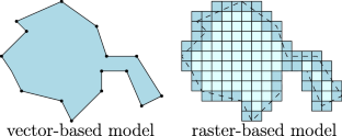
One major goal of spatial query processing is to mitigate I/O costs and minimize the search space. However, geometric computation can be heavy-duty for spatial queries, in particular for complex geometries such as polygons with many edges based on a vector-based representation. Many past techniques have been provided for spatial partitioning and indexing, which are mainly built on minimal bounding boxes or other approximation methods and are not optimized for reducing geometric computation. In this paper, we propose a novel vector-raster hybrid approach through rasterization, where rich pixel-centric information is preserved to help not only filter out more candidates but also reduce geometry computation load. Based on the hybrid model, we implement four typical spatial queries, which can be generalized for other types of spatial queries. We also propose cost models to estimate the latency for those query types. Our experiments demonstrate that the hybrid model can boost the performance of spatial queries on complex polygons by up to one order of magnitude.
期刊介绍:
GeoInformatica is located at the confluence of two rapidly advancing domains: Computer Science and Geographic Information Science; nowadays, Earth studies use more and more sophisticated computing theory and tools, and computer processing of Earth observations through Geographic Information Systems (GIS) attracts a great deal of attention from governmental, industrial and research worlds.
This journal aims to promote the most innovative results coming from the research in the field of computer science applied to geographic information systems. Thus, GeoInformatica provides an effective forum for disseminating original and fundamental research and experience in the rapidly advancing area of the use of computer science for spatial studies.


 分享
分享
 求助内容:
求助内容: 应助结果提醒方式:
 扫码关注我们
