J. W. Snedden, M. G. Rowan, D. F. Stockli, M. Albertson, J. Pasley
{"title":"重建扎马(墨西哥)发现的源汇古地理学,第二部分:从晚中新世陆架边缘到深水盆地的沉积路线","authors":"J. W. Snedden, M. G. Rowan, D. F. Stockli, M. Albertson, J. Pasley","doi":"10.1111/bre.12849","DOIUrl":null,"url":null,"abstract":"<p>The Late Miocene source terrane tectonic history in the southern Gulf of Mexico Basin, as informed by detrital zircon geothermochronology data, supports a detailed regional palaeogeographic reconstruction from palaeoshoreline to the deepwater Zama minibasin of the Sureste salt basin. Seismic mapping points to a trio of pathways that converge upon two entry points into the Zama minibasin, illuminating how sediment gravity flows transit a complex seascape defined by shallow salt bodies. Consideration of empirical scaling relationships within and between segments of this sediment dispersal system allows for testable predictions of Upper Miocene submarine fan-runout lengths over basin exploration areas. Distances from the reconstructed shelf-margin to the Zama wells vary around 100 km, an increase of 20% over a straight-line distance as flows likely navigated around extant salt stocks, walls and sheets. This 100-km fan length is about 40% of the reconstructed minimum palaeo-river length, within predicted ranges for smaller source-to-sink systems in tectonically active areas (25 to 50%). The estimated fan-runout distance can be extended even further basinwards, considering the contemporaneous passage of the mobile Chortis block along the Tonala shear zone, expanding the Palaeo-Rio Grijalva drainage network during the Tortonian. These Late Miocene deepwater systems linked to the Palaeo-Rio Grijalva differ substantially from onshore Mexico-sourced turbidity flows feeding into the axis of the north-trending Veracruz Trough. Textural data from wells here suggests these systems were less effective at larger grain transport and sorting. Local (intrabasinal) variations are also evident within the Zama minibasin, as well data (image logs and cores) indicate that axially oriented sediment gravity flows involved fewer high-density turbidities, depositing lower net-to-gross sandstones and thicker shales than those flowing transverse to the basin axis from a southeastern basin entry point. These interpretations will guide both local exploitation of these economic resources and could also support future exploration for analogous salt-influenced deepwater reservoir systems in the Sureste basin and globally.</p>","PeriodicalId":8712,"journal":{"name":"Basin Research","volume":"36 1","pages":""},"PeriodicalIF":2.6000,"publicationDate":"2024-02-05","publicationTypes":"Journal Article","fieldsOfStudy":null,"isOpenAccess":false,"openAccessPdf":"","citationCount":"0","resultStr":"{\"title\":\"Reconstructing the Zama (Mexico) discovery source to sink palaeogeography, Part II: Sediment routing from the Late Miocene shelf-margin to deepwater basin\",\"authors\":\"J. W. Snedden, M. G. Rowan, D. F. Stockli, M. Albertson, J. Pasley\",\"doi\":\"10.1111/bre.12849\",\"DOIUrl\":null,\"url\":null,\"abstract\":\"<p>The Late Miocene source terrane tectonic history in the southern Gulf of Mexico Basin, as informed by detrital zircon geothermochronology data, supports a detailed regional palaeogeographic reconstruction from palaeoshoreline to the deepwater Zama minibasin of the Sureste salt basin. Seismic mapping points to a trio of pathways that converge upon two entry points into the Zama minibasin, illuminating how sediment gravity flows transit a complex seascape defined by shallow salt bodies. Consideration of empirical scaling relationships within and between segments of this sediment dispersal system allows for testable predictions of Upper Miocene submarine fan-runout lengths over basin exploration areas. Distances from the reconstructed shelf-margin to the Zama wells vary around 100 km, an increase of 20% over a straight-line distance as flows likely navigated around extant salt stocks, walls and sheets. This 100-km fan length is about 40% of the reconstructed minimum palaeo-river length, within predicted ranges for smaller source-to-sink systems in tectonically active areas (25 to 50%). The estimated fan-runout distance can be extended even further basinwards, considering the contemporaneous passage of the mobile Chortis block along the Tonala shear zone, expanding the Palaeo-Rio Grijalva drainage network during the Tortonian. These Late Miocene deepwater systems linked to the Palaeo-Rio Grijalva differ substantially from onshore Mexico-sourced turbidity flows feeding into the axis of the north-trending Veracruz Trough. Textural data from wells here suggests these systems were less effective at larger grain transport and sorting. Local (intrabasinal) variations are also evident within the Zama minibasin, as well data (image logs and cores) indicate that axially oriented sediment gravity flows involved fewer high-density turbidities, depositing lower net-to-gross sandstones and thicker shales than those flowing transverse to the basin axis from a southeastern basin entry point. These interpretations will guide both local exploitation of these economic resources and could also support future exploration for analogous salt-influenced deepwater reservoir systems in the Sureste basin and globally.</p>\",\"PeriodicalId\":8712,\"journal\":{\"name\":\"Basin Research\",\"volume\":\"36 1\",\"pages\":\"\"},\"PeriodicalIF\":2.6000,\"publicationDate\":\"2024-02-05\",\"publicationTypes\":\"Journal Article\",\"fieldsOfStudy\":null,\"isOpenAccess\":false,\"openAccessPdf\":\"\",\"citationCount\":\"0\",\"resultStr\":null,\"platform\":\"Semanticscholar\",\"paperid\":null,\"PeriodicalName\":\"Basin Research\",\"FirstCategoryId\":\"89\",\"ListUrlMain\":\"https://onlinelibrary.wiley.com/doi/10.1111/bre.12849\",\"RegionNum\":2,\"RegionCategory\":\"地球科学\",\"ArticlePicture\":[],\"TitleCN\":null,\"AbstractTextCN\":null,\"PMCID\":null,\"EPubDate\":\"\",\"PubModel\":\"\",\"JCR\":\"Q2\",\"JCRName\":\"GEOSCIENCES, MULTIDISCIPLINARY\",\"Score\":null,\"Total\":0}","platform":"Semanticscholar","paperid":null,"PeriodicalName":"Basin Research","FirstCategoryId":"89","ListUrlMain":"https://onlinelibrary.wiley.com/doi/10.1111/bre.12849","RegionNum":2,"RegionCategory":"地球科学","ArticlePicture":[],"TitleCN":null,"AbstractTextCN":null,"PMCID":null,"EPubDate":"","PubModel":"","JCR":"Q2","JCRName":"GEOSCIENCES, MULTIDISCIPLINARY","Score":null,"Total":0}
Reconstructing the Zama (Mexico) discovery source to sink palaeogeography, Part II: Sediment routing from the Late Miocene shelf-margin to deepwater basin
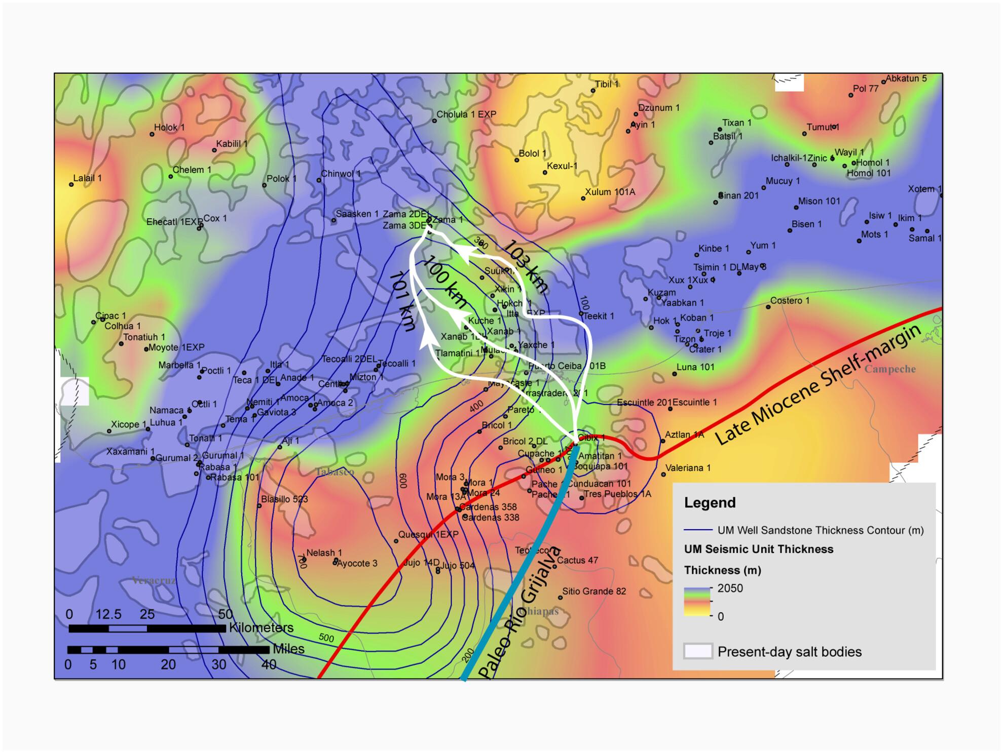
The Late Miocene source terrane tectonic history in the southern Gulf of Mexico Basin, as informed by detrital zircon geothermochronology data, supports a detailed regional palaeogeographic reconstruction from palaeoshoreline to the deepwater Zama minibasin of the Sureste salt basin. Seismic mapping points to a trio of pathways that converge upon two entry points into the Zama minibasin, illuminating how sediment gravity flows transit a complex seascape defined by shallow salt bodies. Consideration of empirical scaling relationships within and between segments of this sediment dispersal system allows for testable predictions of Upper Miocene submarine fan-runout lengths over basin exploration areas. Distances from the reconstructed shelf-margin to the Zama wells vary around 100 km, an increase of 20% over a straight-line distance as flows likely navigated around extant salt stocks, walls and sheets. This 100-km fan length is about 40% of the reconstructed minimum palaeo-river length, within predicted ranges for smaller source-to-sink systems in tectonically active areas (25 to 50%). The estimated fan-runout distance can be extended even further basinwards, considering the contemporaneous passage of the mobile Chortis block along the Tonala shear zone, expanding the Palaeo-Rio Grijalva drainage network during the Tortonian. These Late Miocene deepwater systems linked to the Palaeo-Rio Grijalva differ substantially from onshore Mexico-sourced turbidity flows feeding into the axis of the north-trending Veracruz Trough. Textural data from wells here suggests these systems were less effective at larger grain transport and sorting. Local (intrabasinal) variations are also evident within the Zama minibasin, as well data (image logs and cores) indicate that axially oriented sediment gravity flows involved fewer high-density turbidities, depositing lower net-to-gross sandstones and thicker shales than those flowing transverse to the basin axis from a southeastern basin entry point. These interpretations will guide both local exploitation of these economic resources and could also support future exploration for analogous salt-influenced deepwater reservoir systems in the Sureste basin and globally.
期刊介绍:
Basin Research is an international journal which aims to publish original, high impact research papers on sedimentary basin systems. We view integrated, interdisciplinary research as being essential for the advancement of the subject area; therefore, we do not seek manuscripts focused purely on sedimentology, structural geology, or geophysics that have a natural home in specialist journals. Rather, we seek manuscripts that treat sedimentary basins as multi-component systems that require a multi-faceted approach to advance our understanding of their development. During deposition and subsidence we are concerned with large-scale geodynamic processes, heat flow, fluid flow, strain distribution, seismic and sequence stratigraphy, modelling, burial and inversion histories. In addition, we view the development of the source area, in terms of drainage networks, climate, erosion, denudation and sediment routing systems as vital to sedimentary basin systems. The underpinning requirement is that a contribution should be of interest to earth scientists of more than one discipline.


 分享
分享
 求助内容:
求助内容: 应助结果提醒方式:
 扫码关注我们
