Diego Panici, Georgina L. Bennett, Richard J. Boothroyd, Clàudia Abancó, Richard D. Williams, Fibor Tan, Mark Matera
{"title":"热带河流环境中的观测数据和计算多相模型显示,降雨引发的山体滑坡导致下游河道发生复杂变化","authors":"Diego Panici, Georgina L. Bennett, Richard J. Boothroyd, Clàudia Abancó, Richard D. Williams, Fibor Tan, Mark Matera","doi":"10.1002/esp.5841","DOIUrl":null,"url":null,"abstract":"<p>Alluvial river channels respond to changes in sediment supply by adjusting their geometry. Landslide sediment delivery and geomorphic response of river channels during floods are poorly understood and rarely examined in tropical settings. We investigate the impact of landslides on channel geomorphic changes during an extreme typhoon-induced flood event in the Philippines, specifically the complex geomorphic response of the Antamok River to Typhoon Mangkhut in September 2018, which triggered >500 landslides in the Ambalanga catchment. The catchment has a legacy of anthropogenic modifications, such as extensive small-scale (artisanal) mining and tailings storage facilities (TSFs) from large-scale mining activities.</p><p>We use a novel mix of mapping and computational modelling approaches to test the hypothesis that landslide sediment delivery is a major control on channel geomorphic change. Pre- and post-event imagery show that the overall active channel area increased by 35.9% and the mean active channel width increased by 9.1 m. Spatially, we find no clear relationship between landslide sediment input or unit stream power and channel width geomorphic change, with longitudinal changes in active channel width complicated by TSFs. Multi-phase modelling using r.avaflow revealed how landslide sediment delivery and TSFs interacted with the flow to generate the observed patterns of channel change. The model simulated channel incision in the upper parts of the catchment (up to 0.78 m) and deposition in the TSFs (up to 1.73 m).</p><p>Our findings demonstrate that well-established methods (e.g., stream power threshold) fail to fully explain channel width geomorphic changes, particularly for anthropogenically altered catchments. Integrating techniques, such as landslide mapping and multi-phase computational modelling improves understanding of sediment supply's role in channel width change during extreme events. Numerical simulations also demonstrate that conventional assumptions of increased erosion and deposition with rising flow discharge are inaccurate with large sediment input, highlighting instead the effectiveness of multi-phase models.</p>","PeriodicalId":11408,"journal":{"name":"Earth Surface Processes and Landforms","volume":null,"pages":null},"PeriodicalIF":2.8000,"publicationDate":"2024-04-10","publicationTypes":"Journal Article","fieldsOfStudy":null,"isOpenAccess":false,"openAccessPdf":"https://onlinelibrary.wiley.com/doi/epdf/10.1002/esp.5841","citationCount":"0","resultStr":"{\"title\":\"Observations and computational multi-phase modelling in tropical river settings show complex channel changes downstream from rainfall-triggered landslides\",\"authors\":\"Diego Panici, Georgina L. Bennett, Richard J. Boothroyd, Clàudia Abancó, Richard D. Williams, Fibor Tan, Mark Matera\",\"doi\":\"10.1002/esp.5841\",\"DOIUrl\":null,\"url\":null,\"abstract\":\"<p>Alluvial river channels respond to changes in sediment supply by adjusting their geometry. Landslide sediment delivery and geomorphic response of river channels during floods are poorly understood and rarely examined in tropical settings. We investigate the impact of landslides on channel geomorphic changes during an extreme typhoon-induced flood event in the Philippines, specifically the complex geomorphic response of the Antamok River to Typhoon Mangkhut in September 2018, which triggered >500 landslides in the Ambalanga catchment. The catchment has a legacy of anthropogenic modifications, such as extensive small-scale (artisanal) mining and tailings storage facilities (TSFs) from large-scale mining activities.</p><p>We use a novel mix of mapping and computational modelling approaches to test the hypothesis that landslide sediment delivery is a major control on channel geomorphic change. Pre- and post-event imagery show that the overall active channel area increased by 35.9% and the mean active channel width increased by 9.1 m. Spatially, we find no clear relationship between landslide sediment input or unit stream power and channel width geomorphic change, with longitudinal changes in active channel width complicated by TSFs. Multi-phase modelling using r.avaflow revealed how landslide sediment delivery and TSFs interacted with the flow to generate the observed patterns of channel change. The model simulated channel incision in the upper parts of the catchment (up to 0.78 m) and deposition in the TSFs (up to 1.73 m).</p><p>Our findings demonstrate that well-established methods (e.g., stream power threshold) fail to fully explain channel width geomorphic changes, particularly for anthropogenically altered catchments. Integrating techniques, such as landslide mapping and multi-phase computational modelling improves understanding of sediment supply's role in channel width change during extreme events. Numerical simulations also demonstrate that conventional assumptions of increased erosion and deposition with rising flow discharge are inaccurate with large sediment input, highlighting instead the effectiveness of multi-phase models.</p>\",\"PeriodicalId\":11408,\"journal\":{\"name\":\"Earth Surface Processes and Landforms\",\"volume\":null,\"pages\":null},\"PeriodicalIF\":2.8000,\"publicationDate\":\"2024-04-10\",\"publicationTypes\":\"Journal Article\",\"fieldsOfStudy\":null,\"isOpenAccess\":false,\"openAccessPdf\":\"https://onlinelibrary.wiley.com/doi/epdf/10.1002/esp.5841\",\"citationCount\":\"0\",\"resultStr\":null,\"platform\":\"Semanticscholar\",\"paperid\":null,\"PeriodicalName\":\"Earth Surface Processes and Landforms\",\"FirstCategoryId\":\"89\",\"ListUrlMain\":\"https://onlinelibrary.wiley.com/doi/10.1002/esp.5841\",\"RegionNum\":3,\"RegionCategory\":\"地球科学\",\"ArticlePicture\":[],\"TitleCN\":null,\"AbstractTextCN\":null,\"PMCID\":null,\"EPubDate\":\"\",\"PubModel\":\"\",\"JCR\":\"Q2\",\"JCRName\":\"GEOGRAPHY, PHYSICAL\",\"Score\":null,\"Total\":0}","platform":"Semanticscholar","paperid":null,"PeriodicalName":"Earth Surface Processes and Landforms","FirstCategoryId":"89","ListUrlMain":"https://onlinelibrary.wiley.com/doi/10.1002/esp.5841","RegionNum":3,"RegionCategory":"地球科学","ArticlePicture":[],"TitleCN":null,"AbstractTextCN":null,"PMCID":null,"EPubDate":"","PubModel":"","JCR":"Q2","JCRName":"GEOGRAPHY, PHYSICAL","Score":null,"Total":0}
Observations and computational multi-phase modelling in tropical river settings show complex channel changes downstream from rainfall-triggered landslides
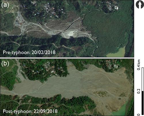
Alluvial river channels respond to changes in sediment supply by adjusting their geometry. Landslide sediment delivery and geomorphic response of river channels during floods are poorly understood and rarely examined in tropical settings. We investigate the impact of landslides on channel geomorphic changes during an extreme typhoon-induced flood event in the Philippines, specifically the complex geomorphic response of the Antamok River to Typhoon Mangkhut in September 2018, which triggered >500 landslides in the Ambalanga catchment. The catchment has a legacy of anthropogenic modifications, such as extensive small-scale (artisanal) mining and tailings storage facilities (TSFs) from large-scale mining activities.
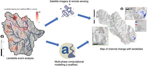
We use a novel mix of mapping and computational modelling approaches to test the hypothesis that landslide sediment delivery is a major control on channel geomorphic change. Pre- and post-event imagery show that the overall active channel area increased by 35.9% and the mean active channel width increased by 9.1 m. Spatially, we find no clear relationship between landslide sediment input or unit stream power and channel width geomorphic change, with longitudinal changes in active channel width complicated by TSFs. Multi-phase modelling using r.avaflow revealed how landslide sediment delivery and TSFs interacted with the flow to generate the observed patterns of channel change. The model simulated channel incision in the upper parts of the catchment (up to 0.78 m) and deposition in the TSFs (up to 1.73 m).
Our findings demonstrate that well-established methods (e.g., stream power threshold) fail to fully explain channel width geomorphic changes, particularly for anthropogenically altered catchments. Integrating techniques, such as landslide mapping and multi-phase computational modelling improves understanding of sediment supply's role in channel width change during extreme events. Numerical simulations also demonstrate that conventional assumptions of increased erosion and deposition with rising flow discharge are inaccurate with large sediment input, highlighting instead the effectiveness of multi-phase models.
期刊介绍:
Earth Surface Processes and Landforms is an interdisciplinary international journal concerned with:
the interactions between surface processes and landforms and landscapes;
that lead to physical, chemical and biological changes; and which in turn create;
current landscapes and the geological record of past landscapes.
Its focus is core to both physical geographical and geological communities, and also the wider geosciences


 分享
分享
 求助内容:
求助内容: 应助结果提醒方式:
 扫码关注我们
