José Barahona, Hernán Alcayaga, Diego Caamaño, Luca Mao, Christian González
{"title":"智利拉哈河受多重干扰河段的协同过程相互作用和形态变化","authors":"José Barahona, Hernán Alcayaga, Diego Caamaño, Luca Mao, Christian González","doi":"10.1002/esp.5832","DOIUrl":null,"url":null,"abstract":"<p>This work studies the multiple sources of impacts and disturbances in the Laja River (Central Chile) and evaluates the changes in water and sediment flows and planimetric geomorphic changes.</p><p>The disturbances sources correspond to hydroelectric plants, water withdrawals for irrigation and the sustained decrease trend in rainfall in the basin. The changes in the plan-view shape of the river reach were quantified using remote sensing techniques, through a supervised classification of Landsat 5 TM and 8 OLI satellite images, identified Water (W), Islands and Riverine Vegetation (IRV) and Bars and Banks Without Vegetation (BBWV), obtained a Kappa index>0,83 for a period of 15 years (2006–2021).</p><p>Compared with historical records, the period of analysis shows a decrease in annual rainfall by 17.5%. In addition, water withdrawals for irrigation have contributed to a 64% decrease in monthly stream discharge during the dry season. As a consequence of the decrease in annual rainfall and water withdrawals for irrigation, the sediment transport capacity has also decreased by 10.5%.</p><p>The changes in morphological driving variables (stream flows and sediment transport regimes) have manifested themselves in morphological changes, where it was possible to establish that a change in the channel form occurred in the last 15 years, going from a river with a single channel to a braided one. An important vegetation establishment has accompanied this morphological change on both riverbanks and the central bars. The colonizing vegetation corresponds to fast-growing non-native species (<i>Salix</i> spp., <i>Populus</i> spp. and <i>Alnus spp</i>). A stabilization of the channel form is expected, consolidating itself as a braided section with alternating vegetated bars.</p>","PeriodicalId":11408,"journal":{"name":"Earth Surface Processes and Landforms","volume":"49 8","pages":"2348-2366"},"PeriodicalIF":2.7000,"publicationDate":"2024-04-03","publicationTypes":"Journal Article","fieldsOfStudy":null,"isOpenAccess":false,"openAccessPdf":"","citationCount":"0","resultStr":"{\"title\":\"Synergistic process interactions and morphological change in a river reach subject to multiple disturbances, the Laja River, Chile\",\"authors\":\"José Barahona, Hernán Alcayaga, Diego Caamaño, Luca Mao, Christian González\",\"doi\":\"10.1002/esp.5832\",\"DOIUrl\":null,\"url\":null,\"abstract\":\"<p>This work studies the multiple sources of impacts and disturbances in the Laja River (Central Chile) and evaluates the changes in water and sediment flows and planimetric geomorphic changes.</p><p>The disturbances sources correspond to hydroelectric plants, water withdrawals for irrigation and the sustained decrease trend in rainfall in the basin. The changes in the plan-view shape of the river reach were quantified using remote sensing techniques, through a supervised classification of Landsat 5 TM and 8 OLI satellite images, identified Water (W), Islands and Riverine Vegetation (IRV) and Bars and Banks Without Vegetation (BBWV), obtained a Kappa index>0,83 for a period of 15 years (2006–2021).</p><p>Compared with historical records, the period of analysis shows a decrease in annual rainfall by 17.5%. In addition, water withdrawals for irrigation have contributed to a 64% decrease in monthly stream discharge during the dry season. As a consequence of the decrease in annual rainfall and water withdrawals for irrigation, the sediment transport capacity has also decreased by 10.5%.</p><p>The changes in morphological driving variables (stream flows and sediment transport regimes) have manifested themselves in morphological changes, where it was possible to establish that a change in the channel form occurred in the last 15 years, going from a river with a single channel to a braided one. An important vegetation establishment has accompanied this morphological change on both riverbanks and the central bars. The colonizing vegetation corresponds to fast-growing non-native species (<i>Salix</i> spp., <i>Populus</i> spp. and <i>Alnus spp</i>). A stabilization of the channel form is expected, consolidating itself as a braided section with alternating vegetated bars.</p>\",\"PeriodicalId\":11408,\"journal\":{\"name\":\"Earth Surface Processes and Landforms\",\"volume\":\"49 8\",\"pages\":\"2348-2366\"},\"PeriodicalIF\":2.7000,\"publicationDate\":\"2024-04-03\",\"publicationTypes\":\"Journal Article\",\"fieldsOfStudy\":null,\"isOpenAccess\":false,\"openAccessPdf\":\"\",\"citationCount\":\"0\",\"resultStr\":null,\"platform\":\"Semanticscholar\",\"paperid\":null,\"PeriodicalName\":\"Earth Surface Processes and Landforms\",\"FirstCategoryId\":\"89\",\"ListUrlMain\":\"https://onlinelibrary.wiley.com/doi/10.1002/esp.5832\",\"RegionNum\":3,\"RegionCategory\":\"地球科学\",\"ArticlePicture\":[],\"TitleCN\":null,\"AbstractTextCN\":null,\"PMCID\":null,\"EPubDate\":\"\",\"PubModel\":\"\",\"JCR\":\"Q2\",\"JCRName\":\"GEOGRAPHY, PHYSICAL\",\"Score\":null,\"Total\":0}","platform":"Semanticscholar","paperid":null,"PeriodicalName":"Earth Surface Processes and Landforms","FirstCategoryId":"89","ListUrlMain":"https://onlinelibrary.wiley.com/doi/10.1002/esp.5832","RegionNum":3,"RegionCategory":"地球科学","ArticlePicture":[],"TitleCN":null,"AbstractTextCN":null,"PMCID":null,"EPubDate":"","PubModel":"","JCR":"Q2","JCRName":"GEOGRAPHY, PHYSICAL","Score":null,"Total":0}
Synergistic process interactions and morphological change in a river reach subject to multiple disturbances, the Laja River, Chile
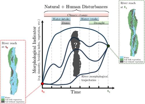
This work studies the multiple sources of impacts and disturbances in the Laja River (Central Chile) and evaluates the changes in water and sediment flows and planimetric geomorphic changes.
The disturbances sources correspond to hydroelectric plants, water withdrawals for irrigation and the sustained decrease trend in rainfall in the basin. The changes in the plan-view shape of the river reach were quantified using remote sensing techniques, through a supervised classification of Landsat 5 TM and 8 OLI satellite images, identified Water (W), Islands and Riverine Vegetation (IRV) and Bars and Banks Without Vegetation (BBWV), obtained a Kappa index>0,83 for a period of 15 years (2006–2021).
Compared with historical records, the period of analysis shows a decrease in annual rainfall by 17.5%. In addition, water withdrawals for irrigation have contributed to a 64% decrease in monthly stream discharge during the dry season. As a consequence of the decrease in annual rainfall and water withdrawals for irrigation, the sediment transport capacity has also decreased by 10.5%.
The changes in morphological driving variables (stream flows and sediment transport regimes) have manifested themselves in morphological changes, where it was possible to establish that a change in the channel form occurred in the last 15 years, going from a river with a single channel to a braided one. An important vegetation establishment has accompanied this morphological change on both riverbanks and the central bars. The colonizing vegetation corresponds to fast-growing non-native species (Salix spp., Populus spp. and Alnus spp). A stabilization of the channel form is expected, consolidating itself as a braided section with alternating vegetated bars.
期刊介绍:
Earth Surface Processes and Landforms is an interdisciplinary international journal concerned with:
the interactions between surface processes and landforms and landscapes;
that lead to physical, chemical and biological changes; and which in turn create;
current landscapes and the geological record of past landscapes.
Its focus is core to both physical geographical and geological communities, and also the wider geosciences


 分享
分享
 求助内容:
求助内容: 应助结果提醒方式:
 扫码关注我们
